Auvare
Auvare (Occitan: Auvara) is a commune in the Alpes-Maritimes department in the Provence-Alpes-Côte d'Azur region of south-eastern France.
Auvare | |
|---|---|
 View of the Village | |
 Coat of arms | |
Location of Auvare 
| |
 Auvare  Auvare | |
| Coordinates: 43°59′20″N 6°54′32″E | |
| Country | France |
| Region | Provence-Alpes-Côte d'Azur |
| Department | Alpes-Maritimes |
| Arrondissement | Nice |
| Canton | Vence |
| Intercommunality | Alpes d'Azur |
| Government | |
| • Mayor (2014-2020) | Bernadette Drogoul |
| Area 1 | 18.27 km2 (7.05 sq mi) |
| Population (2017-01-01)[1] | 31 |
| • Density | 1.7/km2 (4.4/sq mi) |
| Demonym(s) | Auvarois |
| Time zone | UTC+01:00 (CET) |
| • Summer (DST) | UTC+02:00 (CEST) |
| INSEE/Postal code | 06008 /06260 |
| Elevation | 479–2,133 m (1,572–6,998 ft) (avg. 1,100 m or 3,600 ft) |
| 1 French Land Register data, which excludes lakes, ponds, glaciers > 1 km2 (0.386 sq mi or 247 acres) and river estuaries. | |
The inhabitants of the commune are known as Auvarois or Auvaroises.[2]
Geography
Auvare is located some 45 km north-east of Nice (in a direct line) and 6 km north-east of Puget-Théniers in the heart of the Alps. Access to the commune is by the D16 road from Puget-Theniers which passes through the far south of the commune and continues, changing its designation to D316, to join the D2202 just south of Daluis. Access to the village in the centre of the commune is by a small local road which branches from the D16 in the south of the commune and follows a tortuous and long route to the village. There is also an equally tortuous route going west from the village which eventually meets the D316 west of the commune. Apart from the village there is the hamlet of Les Vignes towards the south. The terrain of the commune is alpine and very rugged with no apparent farmland.[3]
Numerous waterways rise in the commune and flow generally south-west including the Roudoule which forms the north-western border, the Vallon du Serre Long, the Vallon de Mous which flows east to the commune boundary where it joins an unnamed stream which flows north-east and forms the north-eastern border, the Ravin de Peichal flows north to join the same stream, and the Vallon d'Auvare with many tributaries which rises north of the village and flows south through the village continuing south to join the Torrent de Mayola.[3]
Neighbouring communes and villages[3]
Places adjacent to Auvare | ||||||||||
|---|---|---|---|---|---|---|---|---|---|---|
| ||||||||||
History
After the Roman conquest (which was completed in 14 BC), Augustus organized the Alps into provinces. The territory of the present commune of Auvare was part of the province of Alpes Maritimae which was attached to the civitas of Glanate (Glandevès). In late antiquity the Diocese of Glandevès defined the limits of this civitas.[4]
The Roudoule Valley was conquered by the French Revolutionary Army in October 1792. The region was annexed by the decree of 31 January 1793 and confirmed by the Treaty of Paris (1796). The French Revolution was apparently well received since a Liberty Tree was planted and remained until the Restoration of the Savoyard State in 1814. The Savoyards hastened to levy taxes bringing a new upheaval to the Auvare community.[5]
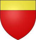
Heraldry
Arms of Auvare |
Blazon: Gules, in chief of Or. |
Administration

List of Successive Mayors[6]
| From | To | Name | Party | Position |
|---|---|---|---|---|
| 1892 | 1892 | Antonin Ravel | ||
| 1892 | 1900 | François Dalmas | ||
| 1900 | 1912 | Antoine Baud | ||
| 1912 | 1919 | Séraphin Baret | ||
| 1919 | 1925 | Paul Laugier | ||
| 1925 | 1943 | Jules Baud | ||
| 1943 | 1947 | Félix Martin | ||
| 1947 | 1953 | Charles Marius Lions | ||
| 1953 | 1977 | Marcel Jourdan | ||
| 1977 | 2008 | Clément Jourdan | DVD | |
| 2008 | Current | Bernadette Drogoul | DVD |
(Not all data is known)
Since 1 January 2014 Auvare has been part of the Community of communes of Alpes d'Azur. It was previously a member of the Community of communes des vallées d'Azur until this disappeared during the implementation of a new departmental plan for inter-communal cooperation.
Population
| Historical population | ||
|---|---|---|
| Year | Pop. | ±% |
| 2006 | 53 | — |
| 2007 | 54 | +1.9% |
| 2008 | 55 | +1.9% |
| 2009 | 52 | −5.5% |
| 2010 | 49 | −5.8% |
| 2011 | 46 | −6.1% |
| 2012 | 45 | −2.2% |
| 2013 | 43 | −4.4% |
| 2014 | 40 | −7.0% |
| 2015 | 36 | −10.0% |
| 2016 | 32 | −11.1% |
Economy
The main economic resource is sheep farming.
See also
Bibliography
- Yves Bernard, Tourist and Cultural Annual for Alpes-Maritimes and Monaco, p. 459, Éditions Campanile, 1997 ISBN 2912366-003 (in French)
Notes and references
Notes
References
- "Populations légales 2017". INSEE. Retrieved 6 January 2020.
- Inhabitants of Alpes-Maritimes (in French)
- Google Maps
- Brigitte Beaujard, The Cities of Southern Gaul from the 3rd to the 7th centuries, Gallia, 63, 2006, CNRS éditions, p. 22 (in French)
- History of Roudoule country, Roudoule, écomusée en terre gavotte, consulted on 19 July 2012 (in French)
- List of Mayors of France (in French)
External links
| Wikimedia Commons has media related to Auvare. |
- Auvare on the old IGN website (in French)
- Auvare on Lion1906
- Auvare on Google Maps
- Auvare on Géoportail, National Geographic Institute (IGN) website (in French)
- Auvare on the INSEE website (in French)
- INSEE (in French)