Amirat
Amirat is a commune in the Alpes-Maritimes department in southeastern France.
Amirat | |
|---|---|
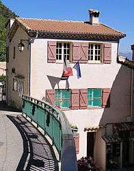 The town hall of Amirat | |
 Coat of arms | |
Location of Amirat 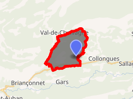
| |
 Amirat  Amirat | |
| Coordinates: 43°53′29″N 6°49′30″E | |
| Country | France |
| Region | Provence-Alpes-Côte d'Azur |
| Department | Alpes-Maritimes |
| Arrondissement | Grasse |
| Canton | Grasse-1 |
| Intercommunality | Pays de Grasse |
| Government | |
| • Mayor (2015-2020) | Jean-Louis Conil |
| Area 1 | 12.95 km2 (5.00 sq mi) |
| Population (2016) | 73 |
| • Density | 5.6/km2 (15/sq mi) |
| Time zone | UTC+01:00 (CET) |
| • Summer (DST) | UTC+02:00 (CEST) |
| INSEE/Postal code | 06002 /06910 |
| Elevation | 725–1,373 m (2,379–4,505 ft) (avg. 860 m or 2,820 ft) |
| 1 French Land Register data, which excludes lakes, ponds, glaciers > 1 km2 (0.386 sq mi or 247 acres) and river estuaries. | |
Geography
This little village is made up of three quarters:
- The Agots, with the church and the hostel.
- Amirat village, where the mayor's office is located.
- Maupoil, location of the 16th century Saint Jeannet's Chapel.
History
Amirat had the fourth highest percentage of people who voted for Jean-Marie Le Pen of all French communes during the second round of voting in 2002 - 59.26%.
Population
The commune's inhabitants are known as Amiratois.
| Historical population | ||
|---|---|---|
| Year | Pop. | ±% |
| 2004 | 26 | — |
| 2006 | 26 | +0.0% |
| 2007 | 35 | +34.6% |
| 2008 | 44 | +25.7% |
| 2009 | 53 | +20.5% |
| 2010 | 55 | +3.8% |
| 2011 | 57 | +3.6% |
| 2012 | 63 | +10.5% |
| 2013 | 69 | +9.5% |
| 2014 | 75 | +8.7% |
| 2015 | 74 | −1.3% |
| 2016 | 73 | −1.4% |
A well known Iyengar yoga instructor, Charles Cartmell, is an Amirat resident.
Politics
Presidential Elections 2nd Round [1]
| Election | Winning Candidate | Party | % | |
|---|---|---|---|---|
| 2017 | Marine Le Pen | FN | 76.47 | |
| 2012 | François Hollande | PS | 54.55 | |
| 2007 | Nicolas Sarkozy | UMP | 58.70 | |
| 2002 | Jean-Marie Le Pen | FN | 59.26 | |
Sights
Saint Jeannet's Chapel, a 16th-century chapel with lovely wooden gate in Maupoil.
External links
| Wikimedia Commons has media related to Amirat. |
This article is issued from Wikipedia. The text is licensed under Creative Commons - Attribution - Sharealike. Additional terms may apply for the media files.