Saguenay–Lac-Saint-Jean
Saguenay–Lac-Saint-Jean (French pronunciation: [saɡnɛ lak sɛ̃ ʒɑ̃], locally [saɡne lak sẽ ʒã]) is a region in Quebec, Canada. It contains the Saguenay Fjord, the estuary of the Saguenay River, stretching through much of the region. It is also known as Sagamie in French, from the first part of "Saguenay" and the last part of "Piekouagami", the Innu name (meaning "flat lake") for Lac Saint-Jean, with the final "e" added to follow the model of other existing region names such as Mauricie, Témiscamie, Jamésie, and Matawinie.[2] The name Saguenay is possibly derived from the Innu word "Saki-nip" which means "where water flows out".[3][4] With a land area of 98,712.71 km2 (38,113.9 sq mi), the Saguenay–Lac-Saint-Jean is, after the Nord-du-Québec and Côte-Nord regions, the third-largest of Quebec regions in the area.
Saguenay–Lac-Saint-Jean | |
|---|---|
Région | |
 Flag | |
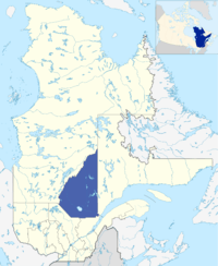 Saguenay–Lac-Saint-Jean's location in comparison to the whole Canadian province of Quebec. | |
| Country | |
| Province | |
| Government | |
| • Regional conference of elected officers | André Paradis (President) |
| Area | |
| • Total | 98,712.71 km2 (38,113.19 sq mi) |
| Population (2016)[1] | |
| • Total | 276,368 |
| • Density | 2.8/km2 (7.3/sq mi) |
| Time zone | UTC−5 (EST) |
| • Summer (DST) | UTC−4 (EDT) |
| Website | Tourism Saguenay-Lac-Saint-Jean |
This region is bathed by two major watercourses, Lac Saint-Jean and the Saguenay River, both of which mark its landscape deeply and have been the main drives of its development in history. It is also irrigated by several other large watercourses. Bordered by forests and mountainous massifs, the southern portion of the region constitutes a fertile enclave in the Canadian Shield called the Saguenay Graben. Both the scenery and the cultural sites and activities of Saguenay–Lac-Saint-Jean attract tourists every year. Lac Saint-Jean is a popular vacation destination in the summer for residents of the more urban regions of Quebec.
The region is considered the heartland of the Quebec sovereignty movement.
The beauty of the region can be seen in the 1991 film Black Robe, directed by Bruce Beresford.
Population
The population of the Saguenay–Lac-Saint-Jean region was 276,368 at the Canada 2016 Census, representing 3.5% of Quebec's population. It is concentrated primarily in three clusters: the city of Saguenay (pop. 144,746), the city of Alma (pop. 30,904) and the agglomeration of Roberval (pop. 10,227), Saint-Félicien (pop. 10,278) and Dolbeau-Mistassini (pop. 14,384).[5] Saguenay, the region's largest city, is located slightly west of the fjord, mostly south of the river.
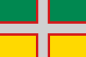
Flag
The flag was incorporated in 1938 on the centenary of the first settlers' arrival in 1838 and was created by Mgr. Victor Tremblay, a local historian. The four colours represent the four elements of the richness of Saguenay: the grey cross represents aluminum, which is an important product of local industry; the red border represents the inhabitants' labour; green, at the top represents the forest; and yellow, at the bottom, represents agriculture.[6]
Subdivisions
Following the Saguenay municipal reorganization in 2002, the region now counts 49 municipalities (including unorganized territories).
Regional County Municipalities (2016 Census populations)
- Le Fjord-du-Saguenay Regional County Municipality (pop. 21,600)
- Lac-Saint-Jean-Est Regional County Municipality (pop. 52,741)
- Le Domaine-du-Roy Regional County Municipality (pop. 31,285)
- Maria-Chapdelaine Regional County Municipality (pop. 24,793)
Independent City
- Saguenay (pop. 144,746)
Native Reserve
- Mashteuiatsh within Le Domaine-du-Roy, (pop. 2,213 Montagnais)
Sources: Government of Quebec, Ministry of Municipal Affairs (MAMROT)
Major communities
School districts
Each school service centre (french:centre de services scolaire) give services to five school distics of 20 in the region:
- Centre de services scolaire de la Jonquière
- Centre de services scolaire du Lac-Saint-Jean
- Centre de services scolaire du Pays-des-Bleuets (Maria-Chapdelaine, Le Domaine-du-Roy, Mashteuiatsh and Saint-Ludger-de-Milot)
- Centre de services scolaire des Rives-du-Saguenay (Le Fjord-du-Saguenay Regional County Municipality (except Larouche, Saint-Ambroise, Bégin), Sagard and Saguenay (except Jonquière))
The hole region is part of the anglophone district Central Quebec School Board.
Francophone centres
References
- "Census Profile, 2016 Census: Saguenay--Lac-Saint-Jean [Economic region], Quebec". Statistics Canada. Retrieved November 22, 2019.
- "Les Outils: Liste des Gentilés" (in French). Gouvernement du Quebec - Commission de Toponymie. Archived from the original on December 22, 2008.
- "La rivière et chemin du Royaume et terre du Saguenay". histoirequebec.qc.ca (in French). Archived from the original on October 25, 2007.
- "Histoire du Saguenay depuis les origines jusqu'à 1870". Our Roots / Nos Racines (in French). University of Calgary, Université Laval. Archived from the original on June 15, 2011.
- "(Code 2475) Census Profile". 2011 census. Statistics Canada. 2012.
- Luc-Vartan Baronian and Nelson Belley: Royaume du Saguenay (Quebec - Canada): Flag use in the Saguenay. 27 January 1997 and 12 January 1998. Retrieved on 16 July 2018.
- Allen, H. D. (May 1968). "Le Saguenay: Region in Transition". The Teachers' Magazine. Montreal: Provincial Association of Protestant Teachers of Quebec. XLVIII (242): 10.
External links
| Wikimedia Commons has media related to Saguenay-Lac-Saint-Jean. |
- Portail du Saguenay-Lac-Saint-Jean Official website
- saguenay lac st jean Tourisme Alma
| Subdivisions | |
|---|---|
| Communities | |
| Major cities | |
| Regions | |
| Subdivisions of Saguenay–Lac-Saint-Jean | |
Portal:Canada | |