Saint-Henri-de-Taillon, Quebec
Saint-Henri-de-Taillon is a municipality in Quebec, Canada.
Saint-Henri-de-Taillon | |
|---|---|
Municipality | |
 | |
 | |
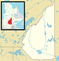 Saint-Henri-de-Taillon Location in Saguenay–Lac-Saint-Jean Quebec. | |
| Coordinates: 48°40′N 71°50′W[1] | |
| Country | |
| Province | |
| Region | Saguenay–Lac-Saint-Jean |
| RCM | Lac-Saint-Jean-Est |
| Settled | 1890s |
| Constituted | August 12, 1903 |
| Government | |
| • Mayor | André Paradis |
| • Federal riding | Roberval—Lac-Saint-Jean |
| • Prov. riding | Lac-Saint-Jean |
| Area | |
| • Total | 62.20 km2 (24.02 sq mi) |
| • Land | 61.41 km2 (23.71 sq mi) |
| Population (2011)[3] | |
| • Total | 760 |
| • Density | 12.4/km2 (32/sq mi) |
| • Pop 2006-2011 | |
| • Dwellings | 524 |
| Time zone | UTC−5 (EST) |
| • Summer (DST) | UTC−4 (EDT) |
| Postal code(s) | G0W 2X0 |
| Area code(s) | 418 and 581 |
| Highways | |
| Website | www |
Demographics
Population trend:[4]
- Population in 2011: 760 (2006 to 2011 population change: 2.8%)
- Population in 2006: 739
- Population in 2001: 776
- Population in 1996: 743
- Population in 1991: 714
Private dwellings occupied by usual residents: 321 (total dwellings: 524)
Mother tongue:[5]
- English as first language: 1.4%
- French as first language: 97.3%
- English and French as first language: 1.4%
- Other as first language: 0%
See also
References
- Reference number 56708 of the Commission de toponymie du Québec (in French)
- Ministère des Affaires municipales, des Régions et de l'Occupation du territoire - Répertoire des municipalités: Saint-Henri-de-Taillon
- "Saint-Henri-de-Taillon census profile". 2011 Census data. Statistics Canada. Retrieved 2010-11-11.
- Statistics Canada: 1996, 2001, 2006, 2011 census
- "Saint-Henri-de-Taillon community profile". 2006 Census data. Statistics Canada. Retrieved 2010-11-11.
Adjacent Municipal Subdivisions | ||||||||||
|---|---|---|---|---|---|---|---|---|---|---|
| ||||||||||
| Cities | |
|---|---|
| Municipalities |
|
| Parishes | |
| Villages | |
| Unorganized territories | |
| |
| Authority control |
|
|---|
This article is issued from Wikipedia. The text is licensed under Creative Commons - Attribution - Sharealike. Additional terms may apply for the media files.