Rivière-Éternité, Quebec
Rivière-Éternité is a municipality, being part of Le Fjord-du-Saguenay Regional County Municipality, located in the administrative region of Saguenay–Lac-Saint-Jean, in Quebec, Canada.[4]
Rivière-Éternité | |
|---|---|
Municipality | |
 Auberge du Presbytère in Rivière-Éternité | |
 | |
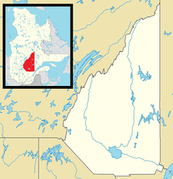 Rivière-Éternité Location in Saguenay–Lac-Saint-Jean Quebec. | |
| Coordinates: 48°15′20″N 70°24′50″W[1] | |
| Country | |
| Province | |
| Region | Saguenay–Lac-Saint-Jean |
| RCM | Le Fjord-du-Saguenay |
| Constituted | July 20, 1974 |
| Government | |
| • Mayor | Rémi Gagné |
| • Federal riding | Chicoutimi—Le Fjord |
| • Prov. riding | Dubuc |
| Area | |
| • Total | 524.50 km2 (202.51 sq mi) |
| • Land | 473.57 km2 (182.85 sq mi) |
| Population (2016)[3] | |
| • Total | 413 |
| • Density | 0.79/km2 (2.0/sq mi) |
| • Pop (2006–11) | |
| • Dwellings | 376 |
| Time zone | UTC−5 (EST) |
| • Summer (DST) | UTC−4 (EDT) |
| Postal code(s) | G0V 1P0 |
| Area code(s) | 418 and 581 |
| Website | www |
Geography
Rivière-Éternité is a small village in Quebec set in the valley of the Éternité River.
It is crossed by route 170.
Toponymy
The Commission de toponymie du Québec writes about it: “The name of this municipality of Saguenay, officially created in 1974, was borrowed from the river that flows there. However, the reason for the designation of this tributary of the Saguenay River, collected between Cape Éternité and Cape Trinité, is unknown. Without doubt, the proximity of Cape Eternity, which evokes the beyond, played a role in the choice of this name which alludes to the absence of beginning and end of the existence of God. Before making us think of the beyond, the term evokes a very long duration. "
She continues: “The landscapes seem to have been fixed there forever and forever, majestically. This name, in addition to identifying the post office established in 1933 and the parish of Notre-Dame-de-l'Éternité erected canonically in 1967, covers the municipality located between Saint-Félix-d'Otis and L'Anse-Saint-Jean. It is the gateway to Saguenay National Park. The presence of water and impressive capes gives the eternity decor a magnificent magnificence in accordance with the extent of the territory which occupies an area of almost 500 km². The specific Eternity appears in documents written since at least 1824, according to the captain Louis Sivrac, and Arthur Buies indicates the cap Éternité, in 1880.[5] "
History
Demography
| Year | 1996 | 2001 | 2006 | 2011 | 2016 |
|---|---|---|---|---|---|
| Population | 572 | 553 | 557 | 484 | 413 |
The 2011 census counted 484 inhabitants, 13.1% less than in 2006.
Administration
Municipal elections are held as a block for the mayor and the six councilors.[6]
| Rivière-Éternité Mayors since 2001 | |||
| Election | Mayor | Quality | Result |
|---|---|---|---|
| 2001 | Rémi Gagné | Voir | |
| 2005 | Voir | ||
| 2009 | Voir | ||
| 2013 | Voir | ||
| 2017 | Voir | ||
| Élection partielle en italique Depuis 2005, les élections sont simultanées dans toutes les municipalités québécoises | |||
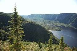
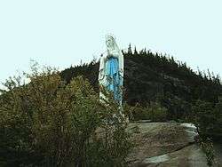
Attractions
One of its attractions is the Eternity Bay sector of the Saguenay Fjord National Park where the fjord reaches its maximum depth. The Cap Trinité path which leads to the statue of Notre-Dame-du-Saguenay offers one of the best views of the fjord.[7]
Photo gallery
 |
Notes and references
- Reference number 85768 of the Commission de toponymie du Québec (in French)
- Ministère des Affaires municipales, des Régions et de l'Occupation du territoire - Répertoire des municipalités: Rivière-Éternité
- "Rivière-Éternité census profile". 2011 Census data. Statistics Canada. Retrieved 2010-10-26.
- Répertoire des municipalités du Québec - Rivière-Éternité
- /ct/ToposWeb/fiche.aspx?no_seq=85768 Commission de toponymie du Québec
- "Liste des municipalités divisées en districts électoraux". DGEQ. Retrieved 31 January 2018.
- # par401 La grande Dame du Saguenay
Appendices
Related articles
External links
Places adjacent to Rivière-Éternité, Quebec | ||||||||||
|---|---|---|---|---|---|---|---|---|---|---|
| ||||||||||
Template:Saguenay–Lac-Saint-Jean palette