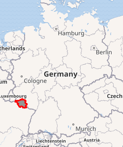
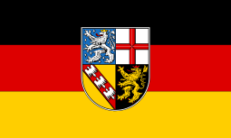
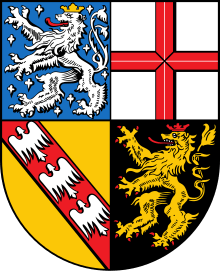
Saarland
Saarland (/ˈsɑːrlænd/, also US: /ˈzɑːr-/, German: [ˈzaːɐ̯lant] (![]()
Saarland | |
|---|---|
| Anthem: "Ich rühm' dich, du freundliches Land an der Saar" ("I praise you, you friendly land on the Saar") | |
| |
| Coordinates: 49°22′59″N 6°49′59″E | |
| Country | Germany |
| Capital | Saarbrücken |
| Government | |
| • Body | Landtag of Saarland |
| • Minister-President | Tobias Hans (CDU) |
| • Governing parties | CDU / SPD |
| • Bundesrat votes | 3 (of 69) |
| Area | |
| • Total | 2,570 km2 (990 sq mi) |
| Population (31 December 2018) | |
| • Total | 990,509 |
| • Density | 390/km2 (1,000/sq mi) |
| Time zone | UTC+1 (CET) |
| • Summer (DST) | UTC+2 (CEST) |
| ISO 3166 code | DE-SL |
| GRP (nominal) | €36 billion (2019)[1] |
| GRP per capita | €37,000 (2019) |
| NUTS Region | DEC |
| HDI (2018) | 0.931[2] very high · 8th of 16 |
| Website | www |
Saarland was established in 1920 after World War I as the Territory of the Saar Basin, occupied and governed by France under a League of Nations mandate. The heavily industrialized region was economically valuable, due to the wealth of its coal deposits and location on the border between France and Germany. Saarland was returned to Nazi Germany in the 1935 Saar status referendum. Following World War II, the French military administration in Allied-occupied Germany organized the territory as the Saar Protectorate from 1947. After the 1955 Saar Statute referendum, it joined the Federal Republic of Germany as a state on 1 January 1957. Saarland used its own currency, the Saar franc, and postage stamps issued specially for the territory until 1959.
History
Before World War I
The region of the Saarland was settled by the Celtic tribes of Treveri and Mediomatrici. The most impressive relic of their time is the remains of a fortress of refuge at Otzenhausen in the north of the Saarland. In the 1st century BC, the Roman Empire made the region part of its province of Belgica. The Celtic population mixed with the Roman immigrants. The region gained wealth, which can still be seen in the remains of Roman villas and villages.
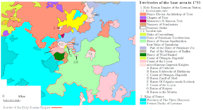
Roman rule ended in the 5th century, when the Franks conquered the territory. For the next 1,300 years the region shared the history of the Kingdom of the Franks, the Carolingian Empire and of the Holy Roman Empire. The region of the Saarland was divided into several small territories, some of which were ruled by sovereigns of adjoining regions. Most important of the local rulers were the counts of Nassau-Saarbrücken. Within the Holy Roman Empire these territories gained a wide range of independence, threatened, however, by the French kings, who sought, from the 17th century onwards, to incorporate all the territories on the western side of the river Rhine and repeatedly invaded the area in 1635, in 1676, in 1679 and in 1734, extending their realm to the Saar River and establishing the city and stronghold of Saarlouis in 1680.
It was not the king of France but the armies of the French Revolution who terminated the independence of the states in the region of the Saarland. After 1792 they conquered the region and made it part of the French Republic. While a strip in the west belonged to the Département Moselle, the centre in 1798 became part of the Département de Sarre, and the east became part of the Département du Mont-Tonnerre. After the defeat of Napoleon in 1815, the region was divided again. Most of it became part of the Prussian Rhine Province. Another part in the east, corresponding to the present Saarpfalz district, was allocated to the Kingdom of Bavaria. A small part in the northeast was ruled by the Duke of Oldenburg.
On 31 July 1870, the French Emperor Napoleon III ordered an invasion across the River Saar to seize Saarbrücken. The first shots of the Franco-Prussian War 1870/71 were fired on the heights of Spichern, south of Saarbrücken. The Saar region became part of the German Empire which came into existence on 18 January 1871, during the course of this war.
Interwar history
In 1920 the Saargebiet was occupied by Britain and France under the provisions of the Treaty of Versailles. The occupied area included portions of the Prussian Rhine Province and the Bavarian Rhenish Palatinate. In practice the region was administered by France. In 1920 this was formalized by a 15-year League of Nations mandate.
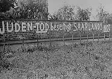
In 1933, a considerable number of communists and other political opponents of National Socialism fled to the Saar, as it was the only part of Germany that remained outside national administration following the First World War. As a result, anti-Nazi groups agitated for the Saarland to remain under French administration. However, with most of the population being ethnically German, such views were considered suspect or even treasonous, and therefore found little support.
When the original 15-year term was over, a plebiscite was held in the territory on 13 January 1935: 90.8% of those voting favoured rejoining Germany.
Following the referendum Josef Bürckel was appointed on 1 March 1935 as the German Reich's commissioner for reintegration (Reichskommissar für die Rückgliederung des Saarlandes). When the reincorporation was considered accomplished, his title was changed (after 17 June 1936) to Reichskommissar für das Saarland. In September 1939, in response to the German Invasion of Poland, French forces invaded the Saarland in a half-hearted offensive, occupying some villages and meeting little resistance, before withdrawing. A further change was made after 8 April 1940 to Reichskommissar für die Saarpfalz; finally, after 11 March 1941, he was made Reichsstatthalter in der "Westmark" (the region's new name, meaning "Western March or Border"). He died on 28 September 1944 and was succeeded by Willi Stöhr, who remained in office until the region fell to advancing American forces in March 1945.
History after World War II
After World War II, the Saarland came under French occupation and administration again, as the Saar Protectorate.
Under the Monnet Plan France attempted to gain economic control of the German industrial areas with large coal and mineral deposits that were not in Soviet hands: the Ruhr and the Saar area. Attempts to gain control of or permanently internationalize the Ruhr area (see International Authority for the Ruhr) were abandoned in 1951 with the German agreement to pool its coal and steel resources (see European Coal and Steel Community) in return for full political control of the Ruhr. The French attempt to gain economic control over the Saar was more successful at the time, with the final vestiges of French economic influence not ending until 1981. France did not annex the Saar or expel the local German population, as opposed to fate of Upper Silesia which was annexed by Poland in 1949 in accordance with the peace treaty between Poland and the GDR/East Germany (see also Allied-occupied Germany).
In his speech "Restatement of Policy on Germany", made in Stuttgart on 6 September 1946, United States Secretary of State James F. Byrnes stated the U.S. motive in detaching the Saar from Germany: "The United States does not feel that it can deny to France, which has been invaded three times by Germany in 70 years,[Note 1] its claim to the Saar territory".
From 1945 to 1951, a policy of industrial disarmament was pursued in Germany by the Allies (see the industrial plans for Germany). As part of this policy, limits were placed on production levels, and industries in the Saar were dismantled just as in the Ruhr, although mostly in the period prior to its detachment (see also the 1949 letter from the UK Foreign Secretary Ernest Bevin to the French Foreign Minister Robert Schuman, urging a reconsideration of the dismantling policy).
In 1948, the French government established the Saarland University under the auspices of the University of Nancy. It is the principal university in the Bundesland, the other being HTW.
The Saar Protectorate was headed by a military governor from 30 August 1945: Gilbert Yves Edmond Grandval (1904 – 1981), who remained, on 1 January 1948, as High Commissioner, and January 1952 – June 1955 as the first of two French ambassadors, his successor being Éric de Carbonnel (1910 – 1965) until 1956. Saarland, however, was allowed a regional administration very early, consecutively headed by:
- a president of the Government:
- 31 July 1945 – 8 June 1946: Hans Neureuther, Non-party
- a chairman of the (until 15 December 1947, Provisional) Administration Commission:
- 8 June 1946 – 20 December 1947: Erwin Müller (b. 1906 – d. 1968), non-party
- Minister-presidents (as in any Bundesland):
- 20 December 1947 – 29 October 1955 Johannes Hoffmann (b. 1890 – d. 1967), CVP
- 29 October 1955 – 10 January 1956 Heinrich Welsch (b. 1888 – d. 1976), Non-party
- 10 January 1956 – 4 June 1957 Hubert Ney (b. 1892 – d. 1984), CDU
In 1954, France and the Federal Republic of Germany (West Germany) developed a detailed plan called the Saarstatut to establish an independent Saarland. It was signed as an agreement between the two countries on 23 October 1954 as one of the Paris Pacts, but a plebiscite held on 23 October 1955 rejected it by 67.7%.
On 27 October 1956, the Saar Treaty declared that Saarland should be allowed to join the Federal Republic of Germany, which it did on 1 January 1957. This was the last significant international border change in Europe until the fall of Communism over 30 years later.
The Saarland's unification with the Federal Republic of Germany was sometimes referred to as the Kleine Wiedervereinigung ("little reunification", in contrast with the post-Cold War absorption of the GDR (Die Wende)). After unification, the Saar franc remained as the territory's currency until West Germany's Deutsche Mark replaced it on 7 July 1959. The Saar Treaty established that French, not English as in the rest of West Germany, should remain the first foreign language taught in Saarland schools; this provision was still largely followed after it was no longer binding.
Since 1971, Saarland has been a member of SaarLorLux, a euroregion created from Saarland, Lorraine, Luxembourg, Rhineland Palatinate, and Wallonia.
Geography
The state borders France (département of Moselle, which forms part of the région of Grand Est) [4] to the south and west, Luxembourg (Grevenmacher District) to the west and Rheinland-Pfalz to the north and the east.
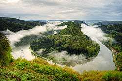
It is named after the Saar River, a tributary of the Moselle River (itself a tributary of the Rhine), which runs through the state from the south to the northwest. One third of the land area of the Saarland is covered by forest, one of the highest percentages in Germany. The state is generally hilly; the highest mountain is the Dollberg with a height of 695.4 m (2281 feet).

Most inhabitants live in a city agglomeration on the French border, surrounding the capital of Saarbrücken.
See also List of places in Saarland.
Districts
Saarland is divided into six districts ("Landkreise" in German):
Demographics
| Historical population | ||
|---|---|---|
| Year | Pop. | ±% p.a. |
| 1926 | 769,300 | — |
| 1930 | 794,500 | +0.81% |
| 1935 | 814,576 | +0.50% |
| 1940 | 812,753 | −0.04% |
| 1945 | 745,612 | −1.71% |
| 1950 | 948,716 | +4.94% |
| 1955 | 996,238 | +0.98% |
| 1960 | 1,060,493 | +1.26% |
| 1965 | 1,127,354 | +1.23% |
| 1970 | 1,121,300 | −0.11% |
| 1975 | 1,096,333 | −0.45% |
| 1980 | 1,066,299 | −0.55% |
| 1985 | 1,045,936 | −0.38% |
| 1990 | 1,072,963 | +0.51% |
| 1995 | 1,084,370 | +0.21% |
| 2000 | 1,068,703 | −0.29% |
| 2005 | 1,050,293 | −0.35% |
| 2010 | 1,017,567 | −0.63% |
| 2015 | 995,597 | −0.44% |
| 2018 | 990,509 | −0.17% |
| source:[5] | ||
| Significant foreign resident populations[6] | |
| Nationality | Population (31.12.2019) |
|---|---|
| 24,970 | |
| 18,620 | |
| 10,260 | |
| 8,510 | |
| 6,805 | |
| 5,895 | |
| 4,680 | |
| 4,470 | |
| 2,280 | |
| 2,210 | |
Largest cities
The following table shows the ten largest cities of Saarland[7]:
| Pos. | Name | Pop. 2017 | Area (km²) | Pop. per km2 |
|---|---|---|---|---|
| 1 | Saarbrücken | 180,966 | 168 | 1,080 |
| 2 | Neunkirchen | 46,767 | 75 | 621 |
| 3 | Homburg (Saar) | 41,934 | 83 | 508 |
| 4 | Völklingen | 39,376 | 67 | 587 |
| 5 | Sankt Ingbert | 35,951 | 50 | 720 |
| 6 | Saarlouis | 34,532 | 43 | 798 |
| 7 | Merzig | 29,818 | 109 | 274 |
| 8 | Sankt Wendel | 25,959 | 114 | 229 |
| 9 | Blieskastel | 20,770 | 108 | 192 |
| 10 | Dillingen | 20,143 | 22 | 914 |
Vital statistics
- Births from January-June 2016 =

- Births from January-June 2017 =
- Deaths from January-June 2016 =

- Deaths from January-June 2017 =

- Natural growth from January-June 2016 =
- Natural growth from January-June 2017 =

Religion
Saarland is the most religious state in Germany. The adherents of the Catholic Church comprise 56.8% of the population, organised in the two dioceses of Trier (comprising the formerly Prussian part of Saarland) and Speyer (for the smaller eastern formerly Palatine part). 17.5% of the Saarlandic population adhere to the Evangelical Church in Germany (EKD), organised in the two Landeskirchen named Evangelical Church in the Rhineland and Evangelical Church of the Palatinate, both following the same former territorial partition. 25.7% are not affiliated with one of these churches.[9]
Saarland has the highest concentration of Roman Catholics of any German state, and is the only state in which Catholics form an absolute majority (over 50%).
Politics
Except for the period between 1985 and 1999 – when the centre-left Social Democratic Party of Germany (SPD) held a majority of seats in the Landtag (state diet) – the centre-right Christian Democratic Union (CDU) has governed the Saarland, either alone or in coalition, continuously since the accession of the state to the Federal of Republic of Germany in 1957.
After the most recent state elections – held in 2012 following the collapse of the "Jamaica coalition" agreement of 2009 between the CDU, the liberal FDP, and the centre-left Bündnis 90/Die Grünen (The Greens) – the CDU and SPD, as the two largest parties in the Landtag, decided upon the formation of a "grand coalition" under the overall leadership of the current minister-president, Tobias Hans (CDU).
Current government of the Saarland
| Office | Incumbent | Since | Party |
|---|---|---|---|
| Minister-president of the Saarland | Tobias Hans | 2018 | CDU |
| Vice Minister-president of the Saarland and Minister for the Economy, Employment, Energy, and Transport |
Anke Rehlinger | 2014 | SPD |
| Minister for the Interior and Sport | Klaus Bouillion | 2014 | CDU |
| Minister for Education and Culture | Ulrich Commerçon | 2012 | SPD |
| Minister of Justice and Minister for the Environment and Consumer Protection |
Reinhold Jost | 2014 | SPD |
| Minister for Social Affairs, Health, Women, and the Family | Monika Bachmann | 2014 | CDU |
| Minister for Finance and European Affairs | Peter Strobel | 2018 | CDU |
| Head of the State Chancellery and Minister plenipotentiary of the Saarland to the Federation in Berlin |
Jürgen Lennartz | 2005 | CDU |
Economy
The Gross domestic product (GDP) of the state was 35.4 billion euros in 2018, accounting for 1.1% of German economic output. GDP per capita adjusted for purchasing power was 32,800 euros or 109% of the EU27 average in the same year. The GDP per employee was 93% of the EU average. The GDP per capita was the second lowest of all states in West Germany.[10]
Important income sources are the automobile industry, steel industry, ceramic industry and computer science and information systems industry. In the past, coal mining[11] was an important branch of industry.
The unemployment rate stood at 5.8% in October 2018 and was higher than the national average but below the EU28 average.[12]
| Year[13] | 2000 | 2001 | 2002 | 2003 | 2004 | 2005 | 2006 | 2007 | 2008 | 2009 | 2010 | 2011 | 2012 | 2013 | 2014 | 2015 | 2016 | 2017 | 2018 |
|---|---|---|---|---|---|---|---|---|---|---|---|---|---|---|---|---|---|---|---|
| Unemployment rate in % | 9.8 | 9.0 | 9.1 | 9.5 | 9.2 | 10.7 | 9.9 | 8.4 | 7.3 | 7.7 | 7.5 | 6.8 | 6.7 | 7.3 | 7.3 | 7.3 | 7.2 | 6.7 | 6.1 |
Education
Saarland is home to the Saarland University and the administrative headquarters of the Franco-German University.
Culture
Local dialect
People in the Saarland speak Rhine Franconian (in the southeast, very similar to that dialect spoken in the western part of the Palatinate) and Moselle Franconian (in the northwest, very similar to that dialect spoken along the Moselle River and the cities of Trier or even in Luxembourg).[14] Outside of the Saarland, specifically the Rhine-Franconian variant spoken in the state capital Saarbrücken is generally considered to be the Saarland dialect. The two dialect regions are mainly separated by the das / dat isogloss; in the northwestern portion of the state, including cities such as Saarlouis, standard German das is pronounced with a final [t] instead of an [s].
In general, both dialects are an integral part of Saarland identity and thus a strong source of local patriotism.
Both dialects, particularly in their respective Saarland flavour, share many characteristic features, some of which will be explained below.
Women and girls are often referred to using the neuter pronoun es, with the pronunciation being something like Ähs: Ähs hat mir's gesaat ('it told me so', instead of 'she told me so'; vs. High German: Sie hat es mir gesagt). This stems from the word Mädchen (girl) being neuter in German (es is correct in German when referring to words like Mädchen but would not be used by itself in reference to a woman).
The conjunctive in Rhine Franconian is normally composed with the words dääd (High German tät = “would do”) or gäng (“would go”) as auxiliary verbs: Isch dääd saan, dass... (“I would say that...”) instead of the High German Ich würde sagen, dass....
Declension is rather different:
- The genitive case does not exist at all and is entirely replaced by constructs with the dative case.
- In most instances, words are not altered when in the dative case. Exceptions are mostly pronouns.
- The same holds for the accusative case. It is accepted practice to use the nominative case instead of the accusative.
Diphthongs are less common than in Standard German. This is because the Standard German diphthongs ei and au are each the result of a merger of two Middle High German vowels – however, these mergers did not take place in the Saarland, and only one of the two merged vowels is pronounced as a diphthong. The front rounded vowels ö, ü, and eu are replaced by e, i, and ei respectively.
Both the Rhine Franconian and Moselle Franconian dialects (and Luxemburgish) have merged the palatal fricative sound as in ich with the post-alveolar fricative as in frisch 'fresh', causing minimal pairs such as Kirche 'church' and Kirsche 'cherry' to be pronounced in the same way.[15]
French has had a considerable influence on the vocabulary, although the pronunciation of imported French words is usually quite different from their originals. Popular examples include Trottwaa (from trottoir), Fissääl (from ficelle), and the imperative or greeting aalleh! (from allez!).
The English sentence 'My house is green' is pronounced almost the same in the Rhine Franconian variant: Mei Haus is grien. The main difference lies in the pronunciation of the r sound.
Regional beer brewer Karlsberg has taken advantage of the Saarlandish dialect to create clever advertising for its staple product, UrPils. Examples include a trio of men enjoying a beer, flanked by baby carriages, the slogan reading "Mutter schafft" (meaning "Mom's at work" in Saarlandish, but plays on the High German word "Mutterschaft", or "motherhood"); another depicts a trio of men at a bar, with one realizing his beer has been drunk by one of the others, the slogan reading "Kenner war's" (meaning "It was no one" [Keiner war es] in Saarlandish, but playing on the High German word "Kenner", or "connoisseur", translating to "It was a connoisseur"); a third shows an empty beer crate in the middle of outer space, the text reading "All" (meaning "empty" in Saarlandish, but playing on the same High German word meaning "outer space").
French
The French language has a special standing in Saarland due to its geographical proximity with France. Today, a large part of the population is able to speak French, and it is compulsory at many schools.[16] Saarbrücken is also home to a bilingual "Deutsch-Französisches Gymnasium" (German-French high school). In January 2014 the Saarland state government announced its aim of making the region fully bilingual in German and French by 2043.[17]
Sports
The Saar competed in the qualifying section of the 1954 FIFA World Cup, but failed after coming second to West Germany but ahead of Norway. It also competed as Saar in the 1952 Summer Olympics and the field handball world championships in the beginning of the 1950s.
References
- "Bruttoinlandsprodukt – in jeweiligen Preisen – 1991 bis 2019". statistik-bw.de.
- "Sub-national HDI - Area Database - Global Data Lab". hdi.globaldatalab.org. Retrieved 2018-09-13.
- "Statistische Ämter des Bundes und der Länder". Statistik-portal.de. Retrieved 2014-03-17.
- Google Maps
- Fortgeschriebener Bevölkerungsstand*) am Jahresende 1926 bis 2018
- Zensus 2014: Bevölkerung am 31. Dezember 2014 31 Dec. 2014 German Statistical Office.
- "Saarland (Germany): Counties, Cities and Communes - Population Statistics, Charts and Map". www.citypopulation.de. Retrieved 2018-12-22.
- "Bevölkerung". Statistische Ämter des Bundes Und der Länder. Retrieved 16 June 2018.
- Evangelische Kirche in Deutschland – Kirchemitgliederzahlen Stand 31. Dezember 2018 EKD, January 2020
- "Regional GDP per capita ranged from 30% to 263% of the EU average in 2018". Eurostat.
- "Last coal marks end of Saarland mining – The Local". Thelocal.de. Retrieved 2014-03-17.
- "Arbeitslosenquote nach Bundesländern in Deutschland 2018 | Statista". Statista (in German). Retrieved 2018-11-13.
- (Destatis), © Statistisches Bundesamt (2018-11-13). "Federal Statistical Office Germany - GENESIS-Online". www-genesis.destatis.de. Retrieved 2018-11-13.
- Stedje, A. (2007). Deutsche Sprache gestern und heute. Munich, Germany: Wilhelm Fink.
- Steitz, L. (1981). Grammatik der Saarbrücker Mundart. Saarbrücken: Saarbrucker Druckerei und Verlag GmbH.
- "Kernlehrpläne – Gesamtschule". Saarland.de. Retrieved 2014-03-17.
- "BBC News – German region of Saarland moves towards bilingualism". Bbc.co.uk. 2014-01-21. Retrieved 2014-03-17.
External links
| Wikimedia Commons has media related to Saarland. |
| Wikivoyage has a travel guide for Saarland. |
- Official governmental portal
- Statistics office
- WorldStatesmen – Germany
- Henze, Sam (3 August 2005). "France, Germany and the Struggle for the War-making Natural Resources of the Rhineland". Archived from the original on 20 August 2012. Describes the contest for the Saar over the centuries.

| States |
|  |
|---|---|---|
| City-states | ||
| Former states |
| |
| Members |
|  | ||||||||
|---|---|---|---|---|---|---|---|---|---|---|
| Institutions | ||||||||||
| Authority control |
|
|---|