Rivington
Rivington is a village and civil parish of the Borough of Chorley, Lancashire, England, occupying 2,538 acres (4.0 sq mi; 10.3 km2). It is about 6 miles (9.7 km) southeast of Chorley and about 8 1⁄2 miles (13.7 km) northwest of Bolton.[1] Rivington is a rural area consisting primarily of agricultural grazing land, moorland, with hill summits including Rivington Pike and Winter Hill within the West Pennine Moors. The area has a thriving tourist industry centred around reservoirs created to serve Liverpool in the Victorian era and Lever Park created as a public park by William Lever at the turn of the 20th century, with two ancient barns, a replica of Liverpool Castle and open countryside. Rivington and its village had a population of 109 at the 2011 Census.[2][3]
| Rivington | |
|---|---|
 Village green and stocks | |
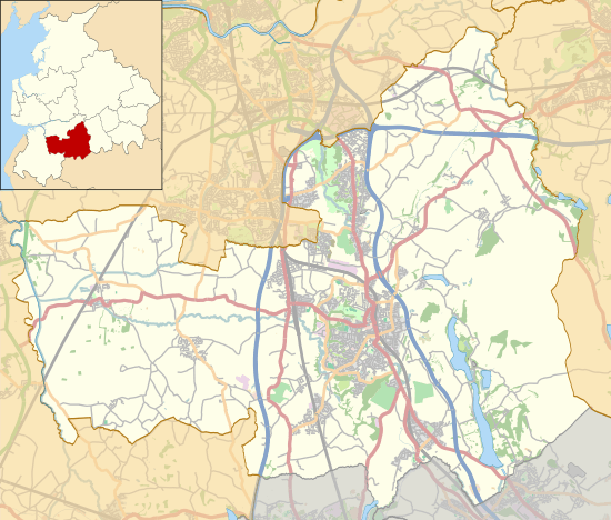 Rivington Shown within Chorley Borough  Rivington Location within Lancashire | |
| Area | 3.97 sq mi (10.3 km2) |
| Population | 109 (2011 Census) |
| • Density | 27/sq mi (10/km2) |
| OS grid reference | SD626144 |
| Civil parish |
|
| District |
|
| Shire county | |
| Region | |
| Country | England |
| Sovereign state | United Kingdom |
| Post town | BOLTON |
| Postcode district | BL6 |
| Dialling code | 01204 |
| Police | Lancashire |
| Fire | Lancashire |
| Ambulance | North West |
| UK Parliament | |
History
Toponymy
The name Rivington is made up of three elements: riv is from the Old English hrēof meaning rough or rugged; ing is a place name forming suffix that seems to have crept in over the years; the last is the Old English tūn meaning a farmstead, estate or settlement.[4][5] Together they indicate a farmstead or settlement at the rough or rugged place. Another suggestion is a place at the rowan trees.[6]
Rivington was recorded in many ways in earlier centuries, Rowinton, Rawinton, and Revington were used in 1202; Ruhwinton in 1212, Riuiton in 1226, Rowynton and Rouynton in 1278, Roynton in 1332, Rouyngton in 1400, Revyngton although rare, and Rovington and Ryvington from the 16th century.[4][6][7]
Early history
A Neolithic or Bronze Age stone, with a cup and ring mark dating from between 2000 and 3000 BC, was found near the Lower Rivington Reservoir in 1999.[8] It is possible that settlements have existed in the area around Rivington since the Bronze Age.[9] Arrowheads, a flint knife, scrapers and the remains of cremations were excavated from a Bronze Age cairn at Noon Hill in 1958 and 1963–64.[10] It is possible that the name Coblowe on the eastern bank of the Lower Rivington Reservoir derives from the Old English hlaw, a hill, which denoted an ancient barrow or burial place.[11] Evidence for the existence of a settlement here in Anglo-Saxon times is found in the Rivington and Coblowe names.[12]
Manor
The majority share of seven-eights of the manor was originally held by the Pilkington family of Lancashire.[13] This share had reduced to five-eights when they sold Rivington Hall in 1611 to their relations Robert Lever and Thomas Breres. A quarter was owned by the Lathoms and an eighth by the Shaws. In 1765 the Shaws and their relations the Roscoes inherited the one-eight share.[14]
The Pilkington share had passed through the female line to the Crompton family after the purchase in 1729 by John Andrews of Little Lever of the Breres' share of the manor.[7] The Cromptons remained resident until 1910 as part of an agreement of sale to W. H. Lever in 1900. Lever sold Rivington Hall and its land to Liverpool Corporation completing in 1905, he and his heirs retain a perpetual interest preventing any buildings being erected except for farms and the supply of water. He retained a residence on the hillside, shooting rights and use of Rivington Hall as a Museum of Lever Park until his death in 1925.[15]
Industry
From 1850 until the completion of the Rivington Reservoir Scheme inhabitants formed businesses providing for its large number of workers. As the Lower Rivington Reservoir was completed the tourist industry was born and has since been dominant alongside farming. Prior to this Rivington was a rural village built around what is now the village green. Its inhabitants were employed in agriculture on scattered local farms. The textile industry was a secondary form of income until the industrial revolution, alongside farming. Textile bleaching took place on the River Douglas at Knoll Wood contaminating the water supply; this was closed and demolished in 1868 by Liverpool Corporation though the remnants of its dam still remain. The Cottage Industry of Handloom weaving and use of the Putting-out system was common in the 18th to early 19th century, Samuel Oldknow was a prominent local figure, his family grave being at the Unitarian Chapel. Income was also generated from the quarries, coal mining was on a small scale at Rivington Moor.[12][7] Rivington Moor Colliery employed two workers mining coal for local use.[16]
A water mill and kiln was mentioned in a deed of 1544 and sale agreement of Rivington Hall in 1611, use of a kiln would have been part of the agricultural milling process.[17] This confirms use of land for arable farming in combination with grazing, the latter is now dominant. A commercial slaughter house was located at the New Hall Barn until its demolition along with the house in 1905, its remains are still present.[12]
The area of the Rivington Unitarian Chapel is named Mill Hill on the 1848 OS map and extended to Croft Bridge, crossing Hall Brook. The Victorian 'School Houses' became known as Mill Hill cottages.[12] Mill Dam wood is at the rear of the Vicarage, a pond existed there prior to the reservoir construction, on the water course is a ruin that could be a past water wheel house and dam, a short distance down stream was a smithy located in the area of what is now the village hall.[18][19]
Reservoirs
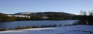
Rivington was dramatically changed by the construction of the Rivington Reservoir Chain, part of the 10,000 acre Rivington watershed,[20] built to provide Liverpool with a safe, clean water supply. Nine properties in the valley were demolished before construction work began. The Rivington Pike Scheme, still in use today, was undertaken by Thomas Hawksley between 1850 and 1857, requiring Liverpool Corporation to purchase large areas of occupied land within the Rivington valley. The scheme was to construct five reservoirs and a water treatment works at the south end of Lower Rivington with a 17-mile (27 km) pipeline to storage reservoirs at Prescot. Water from two higher level reservoirs, Rake Brook and Lower Roddlesworth, was carried south in the Goit, a man-made channel connecting them to the lower reservoirs. In 1900 Liverpool Corporation attempted to acquire the entire area of Rivington to safeguard its water supply, and proposed demolishing the entire village.
The Act of Parliament known as the Liverpool Corporation Act 1902 protected some buildings but others were left vulnerable.[21] The Act allowed the corporation to acquire by compulsory purchase properties in the west of the village, including the Black-a-Moors Head public house (known locally as the 'Black Lad') and New Hall, which were demolished between 1902 and 1905. The result was the small settlement that has remained largely unchanged since then.
Governance
Rivington was a township in the ecclesiastical parish of Bolton le Moors, in the Salford hundred in Lancashire.[22] It became part of the Chorley Poor Law Union, formed in 1837, and took responsibility for the administration and funding of the Poor Law in that area.[23] The parish had an unusual method of deciding their Mayor until the mid 19th century. The person was selected according to how quickly they got drunk on the eve of the annual event known as 'Club Day' when a day of heavy drinking commenced and villagers dressed in fancy dress, going from house to house banging on doors till the early hours of the morning to collect funds for the 'dignity of the office'.[12] In 1866 Rivington became a civil parish. It was part of the Chorley Rural Sanitary District from 1875 to 1894, and part of Chorley Rural District from 1894 to 1974.[24]
Since 1974 Rivington has been a civil parish of the Borough of Chorley, which comprises 47 councillors each elected for four-year terms to represent wards in the borough. Rivington is part of the Heath Charnock and Rivington ward.[25] Chorley is part of the Lancashire County Council created in 1889 under the Local Government Act 1888 and reconstituted under the Local Government Act 1972. Rivington is part of the Chorley Rural East ward.[26]
Rivington is part of the Chorley parliamentary constituency, which elected Lindsay Hoyle as Member of Parliament for the Labour party at the 2010 General Election.[27]
Geography
| Rivington | ||||||||||||||||||||||||||||||||||||||||||||||||||||||||||||
|---|---|---|---|---|---|---|---|---|---|---|---|---|---|---|---|---|---|---|---|---|---|---|---|---|---|---|---|---|---|---|---|---|---|---|---|---|---|---|---|---|---|---|---|---|---|---|---|---|---|---|---|---|---|---|---|---|---|---|---|---|
| Climate chart (explanation) | ||||||||||||||||||||||||||||||||||||||||||||||||||||||||||||
| ||||||||||||||||||||||||||||||||||||||||||||||||||||||||||||
| ||||||||||||||||||||||||||||||||||||||||||||||||||||||||||||
Rivington is situated on the moorland fringe between the high moorland of the West Pennine Moors and the fields below. The landscape is characterised by marginal pastures with isolated farmsteads, reservoirs and disused mines and quarries scattered across the hillsides. There is an extensive network of footpaths providing public access.[29] The reservoir valleys are dominated by expanses of water and the Victorian gothic architecture of the dams and embankments surrounded by woodland.[30]
To the east of Rivington is Rivington Pike and to the west the flatter land of the Lancashire Plain. Rivington is north of Horwich and Bolton and to the south of Anglezarke Moor and Yarrow Reservoir. To the west of the village is the wide shallow valley containing the Anglezarke, Upper and Lower Rivington reservoirs. The village is accessed from the west by a road on top of the 876-foot (267 m) long Horrobin Embankment, a dam that separates the Upper and Lower Rivington reservoirs.[31] The River Douglas has its source on Winter Hill, and flows in a southwest direction forming part of the southern boundary. The River Yarrow has its source on Anglezarke Moor and forms the northern boundary.[7] The area of the township is 2,768 acres (4.3 sq mi; 11 km2), the reservoirs and filter beds occupy 275 acres (111 ha).[32]
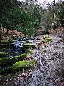
The underlying geology is Millstone Grit overlaid with coal measures. Gritstone was quarried for building stone in the area. Around Rivington are chalybeate springs and in Dean Wood is a waterfall with a descent of 32 feet (9.8 m).[33]
Neighbouring towns, villages and places. | ||||||||||
|---|---|---|---|---|---|---|---|---|---|---|
| ||||||||||
Demography
In 2001, 144 people lived in Rivington, 63 males and 81 females.[34] There were 48 households of which 34 lived in detached houses and 14 in terraced or semi-detached properties. Most households, 60%, were owner-occupied; the remainder were privately rented.[35] The mean age of the population was 53.4 years.[36] In 2001 most of those employed, 47, worked in the service industries. Ten worked in extractive and manufacturing industries, and three males were unemployed. The average distance travelled to work by employed persons was 12.7 miles (20.5 km).[37]
Population change
| Population changes in Rivington since 1801 | |||||||||||||||||||||||||||||||||||||||||||||||||||||||||||||||||||||||
|---|---|---|---|---|---|---|---|---|---|---|---|---|---|---|---|---|---|---|---|---|---|---|---|---|---|---|---|---|---|---|---|---|---|---|---|---|---|---|---|---|---|---|---|---|---|---|---|---|---|---|---|---|---|---|---|---|---|---|---|---|---|---|---|---|---|---|---|---|---|---|---|
|
|
| |||||||||||||||||||||||||||||||||||||||||||||||||||||||||||||||||||||
| Sources:[38][2][39][40][41] | |||||||||||||||||||||||||||||||||||||||||||||||||||||||||||||||||||||||
Economy
In the 19th century, farming was reduced with the construction of the reservoirs. The Industrial Revolution ended the viability of cottage industries such as weaving, small mines closed and the long term population decreased as the Water Authority cleared land in the reservoirs catchment area to protect the water supply, some properties had inadequate sewer treatment facilities and many lacked piped water, farms and other properties were hence taken over and demolished, prior to the reservoirs lower Rivington was fenced off and closed to the public.[12]
The area saw the arrival of a large workforce during reservoir construction, the reservoir chain created a tourist industry, with day-trippers from the dark factories to middle class in visiting in wonder at the new water works scheme. The water scheme resulted in a two Hotels and busy public houses and Tea Rooms the area was thriving with offshoot businesses including a wash house at Rivington Hall supplied by Leverhulmes father, James Lever. The reservoirs led to increasing visitor numbers, this continued and increased further with the opening of Lever Park in 1904, this brought money into the area.[12]
Agriculture, mainly sheep farming, continues.[12][42] Today the area has a thriving tourist industry and a number of Tea Houses, although the Hotel and Public House in the village were demolished visitors are attracted to honeypot sites such as Lever Park and Rivington Pike, making tourism the most significant source of income in the area.[9] Go Ape operates an outdoor activity centre at Great House Barn.[43] Rivington Hall Barn and other sites host private and corporate events.
Transport
Rivington is to the east to the M61 motorway, which connects the M6 and Preston to the north with the M60 and the Greater Manchester conurbation to the south. The nearest access is at Junction 6. The village is accessed by minor roads from Horwich to the south and Adlington to the west. A winding road to the north passes through Anglezarke and a road over the moors to the east leads to Belmont. The nearest places with regular bus services are Horwich to the south and Adlington to the west, which are served by buses between Bolton and Chorley or Preston.
The arrival of the Manchester and Bolton Railway's extension to Preston and opening of Blackrod railway station in 1841 brought visitors to the area. The line remains open with stations at Blackrod and Horwich Parkway giving access to Bolton, Manchester, Chorley and Preston.[44]
Education
Rivington Grammar School's charter was granted to Bishop James Pilkington by Queen Elizabeth I in 1566. The school opened in 1575 and was rebuilt in 1714. Blackrod Grammar School, founded in 1568, merged with it in 1875. In 1882 Rivington & Blackrod Grammar School opened on a site at the south of the township, close to the boundary with Horwich. The school is now Rivington and Blackrod High School, a specialist technology college, focusing on design and technology, mathematics and science. Year Seven pupils occupy the former Horwich County Secondary School.[45]
The old grammar school building in the village centre is now occupied by Rivington Foundation Primary School.[46]
Religion

Rivington was a chapelry in the ancient ecclesiastical parish of Bolton le Moors until it became a parish in its own right. Rivington Church is an active Anglican place of worship holding service each Sunday.[47]
The Church is built on the site of an earlier chapel that was named in a deed by Margaret Pilkington and her son Robert in 1476. The chapelry covered Rivington and the surrounding areas of Anglezarke, Hemshaws and Foulds and was recognised in the Royal patent founding Rivington School in 1566. In 1628 a chapel was built "upon a little toft and quillet of land" by the local population and divine service was celebrated "for many years of antiquity".[7]
The early-16th-century chapel was rebuilt in 1666 and altered and restored in 1861.[12] The church is a small plain building built in sandstone with a bell turret. It is an Anglican church and unusual in that it is not dedicated to a saint or martyr, but referred to as Rivington Church.[47]
Rivington Unitarian Chapel is an active place of worship holding regular services on the first and third Sunday of each month in addition to baptisms, weddings and blessings. The Chapel was built with a bellcote of local stone in 1703. Founded as a Presbyterian church and became Unitarian in the late 18th century. The chapel, which retains its box pews, was restored in 1990.[48]
Landmarks
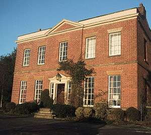
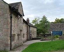
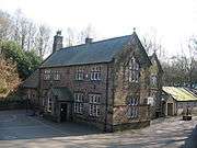
The most prominent of all buildings in Rivington is on the skyline at the summit of Rivington Pike, the tower. There are twenty eight listed buildings within Rivington.[49][50] Outside the village centre landmarks include Rivington Hall and it's adjacent Hall Barn. At Lever Park on the bank of the Lower Rivington Reservoir is a replica of Liverpool Castle, Great House Barn, serving Tea's and snacks and Great House Farm information centre providing information on the area.[51] On the hillside the former Bungalow Grounds contain eleven listed structures, being remains of its garden features, its most prominent feature visible on the skyline being the Pigeon Tower.[52][53] Within the village buildings with listed status are Wilkinson's and cottage attached to right, Rivington School, Rivington Church and the Unitarian Chapel, the two latter being active places of worship. Fisher house operated as a Temperance Hotel in the Victorian era, it is now a secluded private residence.[12][9][54] The village stocks are a feature on Rivington village green, inscribed "T W 1719" on the stone base.
New Hall Barn, opposite the Chapel received planning consent in 2015 to be converted to a four bedroom house. New Hall was a former dwelling and named in deeds of the Pilkington family in 1544[55] on their land named Ferneley in their possession from at least 1336[56][57] and was retained by them at the sale of Rivington Hall in 1611. The house house had a date stone of 1642 and was demolished in the early 20th century after being purchased by Liverpool Corporation, an adjoining barn had been left standing and its site and this barn became part of Bradleys Farm. The barn obsolete after the 1980s and had been left to go to a ruin by its owners United Utilities.[58]
Near Horrobin Embankment, Horrobin Lane which passes between the Lower and Upper Rivington reservoirs is a car park, this was the former site of the Black O'Moors Hotel and Bowling Green Public House, adjacent is Rivington Bowling Club, Bowling Green and Club House, operating as a Tea Room from 11am.[59][60]
Little Lake District

'The Little Lake District' was born in the mid Victorian era when visitor numbers continued to increase, from working classes escaping the gloomy mills on days off to the middle classes aided by a new railway at Blackrod in 1841, close to Horwich Vale. Visitor numbers further increased with a rapid increase in population at Horwich and with the arrival of the Horwich Railway Works and a railway station there, within walking distance. The area attracted well known landscape artists.
The open countryside and moorland had become a public asset the working classes especially wanted to preserve access to and was the site of the Winter Hill mass trespass in 1896.[61] Leverhulme who in 1902 bought a significant amount of land at Rivington also supported open access to the fields and moorland.[62]
Leverhulme was prompted to intervene in 1900 on learning the Cromptons, owners of Rivington Hall were to sell. He was fond of the area that he got to know well as a boy and a place he and his wife frequently visited whilst courting, he had a keen interest in its history, he sponsored and contributed to the book titled 'A Short History of Rivington' published in 1904. [63]
Lever Park
Lever Park is a public park created by the Liverpool Corporation Act 1902[64] now owned by United Utilities, it is a designed landscape adjacent to the Lower Rivington Reservoir and behind Rivington and Blackrod High School toward Rivington Hall Barn created from farm land once belonging to The Crosses Farm, Great House Farm and Rivington Hall.[12][65] The park is named after William Lever, Lord Leverhulme,[66] who bought the land in 1900, in 1901 he proposed the creation of a public park of 364 acres (147 ha)[67] on land he then owned as a gift to the people of his native Bolton. Leverhulme sold the remaining areas outside the park to Liverpool Corporation in 1905 with a covenant on the land preventing building without his or his heirs consent, other than by farms and for operation of the water works.[65][12] Under the terms of a Liverpool Corporation Act 1902[64] the act also enabled him to continue plans proposed to Bolton Council in 1901 for a public park to be completed at his own expense.
The act also obliged Liverpool Corporation and its successors to maintain and keep open the park for the "free and uninterrupted enjoyment of the people of his native town of Bolton".[64][12] Two pillars commemorating the gift of Leverhulme mark the entry to the area named Lever park and are located at the junction of Scholes Bank and Lever Park Avenue, Horwich, inscribed with the words “William Hesketh Lever 1st Viscount Leverhulme. Lever Park the gift of William Hesketh Lever 1st Viscount Leverhulme born at 6 Wood Street, Bolton, September 19, 1851 died at Hampstead, London, May 7, 1925. For the benefit of the citizens of his native town and neighbourhood by act of parliament in 1902 the ownership and care of the park were vested in the Corporation of the City of Liverpool”. The park opened in 1904 and contained a boating lake, a zoo, tree-lined avenues and a network of footpaths. A dedication ceremony took place to dedicate the park to the people of Bolton on 10 October 1911.
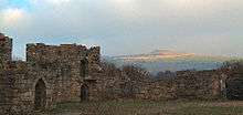
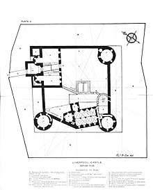
Rivington Castle
Leverhulme commenced the build of a folly, named Rivington Castle in 1911, a scale replica of Liverpool Castle at Coblowe Hillock near the Lower Rivington Reservoir, grade 2 listed since 1967. The build commenced 1912 with clearance of the land and digging foundations, with the first foundation stone laid in 1913[12] and ended on Leverhulmes death in 1925.
The structure has been altered a number of times with the demolition of a stone spiral staircase leading to the 'Great Hall' and stone steps that led to the keep, known as 'The Great Tower', a ledge remains. The castle walls were altered by rebuilding to an angular style at the north wall and near the Keep, stonework was also removed from the wall of the Prison tower as it joins the ante-chapel, the work was undertaken in 2012 as part of safety work in an effort to stop visitors climbing.[68][69]
Leverhulmes Former Gardens
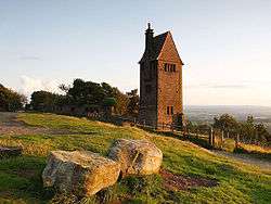
On the hillside of Rivington Pike was an area created as gardens to serve a former Bungalow demolished in 1948 belonging to Leverhulme. The site has surviving stone structures that formed part of the Italian style gardens designed by Thomas Mawson between 1905 and 1922, its design features in his book 'The Art and Craft of Garden Making', published 1912.[70][32] The area is now woodland with remains including foundations of the bungalow, a number of stone summer houses, footpaths, steps, bridges, three ponds, streams and the restored Pigeon Tower. A Japanese style gardens was added in 1923, its features have since been lost, its pond remains. Further down the hillside a section was built as a man made ravine and woodland.[66][71] Roynton Cottage built on the hillside by 1902 was a prefabricated wooden structure, destroyed 1913 in an arson attack by suffragette, Edith Rigby.[72] Its replacement was built of stone in 1914 and named The Bungalow. After Lever's death The Bungalow and grounds were purchased by the Bolton brewer, John Magee he was resident from 1925 until his death in 1939, after which his executor offered the property to Bolton Council who turned it down.
Liverpool Corporation bought the property in late 1939 shortly before the start of the Second World War during which the Bungalow and Grounds were used by the military, after the war proposals were put forward for use other than as a dwelling, the Corporation refused and announced demolition in 1947, the demolition went ahead in 1948. The grounds were subsequently left to neglect, remaining structures became dilapidated and became listed to prevent demolition.[12] In 1974 the park and gardens passed to the North West Water Authority from Liverpool Corporation, and to United Utilities on privatisation. Bolton Conservation Volunteers cleared overgrowth and maintained paths for decades from them first coming into existence in 1976.[73] Free Music festivals were held in the Bungalow Grounds in 1976 and 1977, without the consent of the landowner. All Rhododendron was removed from the gardens in 2006 after Ramorum Disease was found at the site.[74] The ownership of the site transferred by way of a lease to Rivington Heritage Trust in 2016.
Rivington Heritage Trust
Rivington Heritage Trust, a body set up in 1997 by United Utilities in order to obtain £15 million in funding for 'Blue Planet Park' had its plans rejected for funding by the Millennium Commission for plans which would have seen them take over all of Lever Park and Rivington Pike, plans were opposed by six regional MPs and were met with huge local opposition.[75][76][77] Amongst issues raised by the public were fears that Music festivals would be held at the Rivington Terraced Gardens and the public would be charged admission, the water company assured the public that would never happen, since grant funding was gained in 2016 there have been open air music festivals held within the former gardens with over 2000 in attendance and a variety of other themed events are held, admission charged by buying a ticket. They also produce and sell Gin online.[78] The music festival is to be extended to a two-day event by 2020.[79][80] Den Dover was the Constituency Member of parliament serving for the Conservatives, then in government and raised concerns that the bill presented to parliament would give the water company too much power, he feared public access could be restricted and fee's for entry charged. He opposed the plans and the Water company were forced to withdraw their bill in parliament in July 1997, known as the Lever Park Act, where it met with opposition.[81][82] The trust abandoned the plans by 1998 after considerable local opposition.[83] A plan to proceed gradually was formed with an aim to obtain grant funding from the Heritage Lottery Fund, funded in 2013 by a £60,000 grant from the Big Lottery Fund.[84][85] In 2016 the trust and Groundwork Cheshire Lancashire and Merseyside gained a grant of £3.4 million from the Heritage Lottery Fund to conserve and repair the Rivington Terraced Gardens and remaining Grade II listed structures. A lease of 50 years was also agreed by United Utilities to the Rivington Heritage Trust in the same year.[86][86] In the main the unskilled clearance work has been undertaken by unpaid volunteers.[78]
Notable Campaigns
Rivington Moor was the site of a mass trespass of 10,000 people who descended on the area toward Winter Hill in 1896 after the Smithills Hall land owner blocked off the route from Halliwell to Winter Hill and onto Rivington Moor. The demonstration is commemorated by a memorial stone on Coal Pit Lane, below Smithills Moor.[61] Leverhulme was also concerned that access to the fields and moorland of Rivington was becoming more restricted.[62]
On the land Leverhulme donated to create Lever Park it is protected under statutory powers within the Liverpool Corporation Act 1902 ensuring "free and uninterrupted enjoyment". The area is popular with walkers, cyclists and horse riders with footpaths , bridleways and roads providing access to the park, hillside and surrounding moorland.[87] Rivington moor, Winter Hill, Rivington Pike, Brown Hill and the former Japanese and Kitchen Gardens within the Bungalow Grounds are part of an extensive area of open access land recorded at Lancashire County Council and has a right to roam protected by the statutory powers in the Countryside and Rights of Way Act 2000.[88][89]
Lever Park came under threat after water supplies and land forming the catchment area had been moved out of public ownership and were transferred to private corporations in the Water privatisation in England and Wales, this was followed by a significant increase in use of gates and fences with stiles on footpaths and bridleways appearing from 1989, in response at Rivington 3000 local campaigners demonstrated and took a pledge to protect the area from then on after attending a meeting of opponents to the bill, organised as a rally at Rivington, led by the Ramblers Association in association with the Open Spaces Society and attended by Ann Taylor MP; mountaineer Chris Bonington; Ramblers’ chairman Chris Hall; the leader of Lancashire County Council, Louise Ellman, and Kinder Scout trespass veteran Benny Rothman,[90][91][92][12]
Lever Park was again under threat in a further attempt by the water company supported by Horwich Town Council who attempted to remove statutory protection through a parliamentary act in 1997, they were met with considerable local opposition and the act of parliament was blocked a cross party group of six regional Conservative and Labour MPs Terry Lewis, Tom Sackville, Peter Thurnham, Andrew Bennett and Gerald Kaufman and was opposed by the local MP, Den Dover.[93][75][81]
Rights of Way
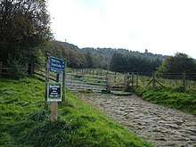
There is a public footpath and a bridleway from Lever Park to Rivington Pike and Terraced Gardens. The public footpath number 82 runs through the gardens from the Ravine via the former Japanese and Kitchen Gardens, which is also an area of open access land with a right to roam, passing upward past the Great Lawn and an area of Bilberries[70] part of the West Pennine Moors SSSI,[94] toward the site of the former Bungalow and landmark Pigeon Tower then heading to Rivington Pike via Belmont Road. The bridleway number 98 is from Lever Park, passing Higher Knoll Farm toward Rivington Pike via Belmont Road.[95]
There are a network of roads that provide access to Rivington recorded on the National Street Gazetteer. Access to the park is by vehicle through Lever Park is via Rivington Lane, (USRN 7401372) the former roads in Lever park are gated and are now bridleways and a network of public footpaths. Toward Rivington Pike the old coach road is Belmont Road (USRN 7400767) and is an open public road from Horwich, the road becomes rougher and less maintained the further up the hill it climbs in the direction of the Pigeon Tower, where it splits. The descending road there leads to Lower House car park but the roads surface is washed away and not maintained, the route leading to Rivington Rd and the moorland is gated. Roynton Road (USRN: 7400820) provides access to the hillside and the Terraced Gardens from Lever Park and Sheep House Lane, from the direction of Chorley, Belmont and Horwich, the route has gates.[96][97][89]
Sport
The Rivington Pike Fell Race has been held on Easter Saturday since 1892. The fell race originally started from the Horwich railway works, but since 1930 from the park entrance at Lever Park Avenue. It attracts around 400 runners. The course is 3 1⁄4 miles (5.2 km) long and has a 700-foot (213 m) ascent.[98][99]
The area around Rivington and Anglezarke was the location for the 2002 Commonwealth Games mountain biking competition.[100] The area is well used by hikers and hillwalkers. The Holcombe Hunt meets each year at Rivington Hall Barn.[101]
Culture
Phoebe Hesketh, lived at Fisher House in the village where she wrote several volumes of poetry and two partly autobiographical books Rivington: the story of a village and Rivington: village of the mountain ash. She also wrote a biography, My Aunt Edith about Edith Rigby the suffragette.[102][103]
The artist Alfred East stayed at Roynton Cottage in summer 1909. Lever commissioned a series of paintings of the surrounding landscape, the reservoirs, country park, village and the pike.[104] Lever gave 15 of them to Bolton Art Gallery[105] and others to Bolton School, the Walker Art Gallery in Liverpool and the Lady Lever Art Gallery[106] at Port Sunlight. East gave two water colours, A glimpse of Rivington Water and In Rivington Park to Kettering Museum and Art Gallery. The gallery acquired an oil painting [From] Rivington Pike that East exhibited at the Royal Academy in 1913 in the 1960s.[104]
The Bolton Museum and Masonic Lodge, Ridgmont House, Horwich hold a painting titled "Rivington Lakes" dated 1872 and with a variation titled Rivington Valley (1857) held at Walker Art Gallery, by Frederick William Hulme.[107]
References
Notes
- Rivington Township Boundaries. GenUKI. Retrieved 6 June 2010.
- "Area: Rivington (Parish): Key Figures for 2011 Census: Key Statistics". Neighbourhood Statistics. Office for National Statistics. Retrieved 16 January 2016.
- "West Pennine Moors Management Plan 2010-2020" (PDF). Blackburn Council. Blackburn and Darwen District Council. Retrieved 23 June 2019.
- Billington 1982, pp. 68–69.
- "Rivington". Key to English Place-Names. the University of Nottingham. Retrieved 23 April 2017.
- Smith 1989, p. 4.
- Farrer & Brownbill 1911, pp. 286–294.
- "History of Anderton Centre". Anderton Centre. Anderton Centre. Retrieved 21 September 2019.
- "Rivington Conservation Area Appraisal and Management Proposals" (PDF). Chorley Council. Retrieved 7 June 2010.
- Historic England. "Noon Hill (43486)". PastScape. Retrieved 16 July 2010.
- Irvine 1904, p. xv.
- Lacey, Paul. "Rivington, Lancashire". Rivington. Angelfire. Retrieved 3 January 2011.
- Pilkington 1912, pp. 29.
- Shaw 1940, pp. 133–134.
- "Liverpool Corporation Act, 1902" (PDF). Office of Public Sector Information (OPSI). Retrieved 24 June 2010.
- North and East Lancashire's Mining Industry in 1896. projects.exeter.ac.uk. Retrieved 7 July 2009.
- "National Farm Building Types". Historic England. Historic England. Retrieved 2 July 2019.
- Rivington Conservation Area Appraisal and Management Proposals (pdf). Chorley Council. 2009. p. 19. Retrieved 20 April 2017.
- Ordnance Survey. Lancashire LXXXVI (includes: Blackrod; Bolton; Horwich.) Surveyed: 1845 to 1847 (Map). National Library of Scotland. Retrieved 17 April 2017.
- "Story of our 'little Lake District'". Lancashire Telegraph. 30 July 2002. Retrieved 31 March 2017.
- "Liverpool Corporation Act, 1902" (PDF). Office of Public Sector Information (OPSI). Retrieved 24 June 2010.
- Rivington. GenUKI. Retrieved 3 June 2010.
- Workhouse. Workhouses.org. Retrieved 4 June 2010.
- Relationships / unit history of Rivington. Vision of Britain. Retrieved 4 June 2010.
- Chorley Council, Democracy. Chorley Council. Retrieved 2 June 2010.
- County Councillors by Local Community. Lancashire County Council. Retrieved 2 June 2010.
- Election Results 2010. bbc.co.uk. Retrieved 5 June 2010.
- Rivington Weather, United Kingdom Weather Averages. Retrieved 23 September 2012.
- Moorland Fringe. Lancashire County Council. Archived from the original on 30 October 2010. Retrieved 21 September 2010.
- Reservoir Valleys. Lancashire County Council. Retrieved 21 September 2010.
- Rivington Reservoirs (main scheme). Engineering Timelines. Archived from the original on 23 February 2012. Retrieved 4 June 2010.
- Smith 1984, p. 40.
- Lewis, Samuel (1848). "Rivington or Rovington". A Topographical Dictionary of England. British History Online. pp. 676–679. Retrieved 4 June 2010.
- "Rivington CP (Parish)". Neighbourhood Statistics. Office for National Statistics. Retrieved 30 June 2010.
- "Parish Profile - Accommodation and Tenure". Neighbourhood Statistics. Office for National Statistics. Retrieved 10 November 2010.
- Parish Profile - People. Office for National Statistics. Retrieved 10 November 2010.
- "Parish Profile - Work and Qualifications". Neighbourhood Statistics. Office for National Statistics. Retrieved 10 November 2010.
- "Area: Rivington (Parish): Key Figures for 2001 Census: Key Statistics". Neighbourhood Statistics. Office for National Statistics. Retrieved 16 January 2016.
- Tatton, Pauline. Local population statistics 1801–1986, Bolton Central Library Archives, Le Mans Crescent, Bolton.
- Rivington SubD Population. A vision of Britain through time. Retrieved 4 June 2010.
- Rivington CP/Ch. Population. A vision of Britain through time. Retrieved 4 June 2010.
- Rawlinson 1969, p. 93.
- Go Ape! Rivington. Visit Manchester. Retrieved 31 March 2017.
- Horwich Parkway (HWI). National Rail. Retrieved 30 June 2010.
- Welcome to Rivington & Blackrod High School. Rivington and Blackrod High School. Retrieved 24 April 2008.
- Rivington Foundation Primary School. LancashireCounty Council. Retrieved 6 March 2010.
- "Sunday Service". Rivington Church. Rivington Church. Retrieved 23 June 2019.
- "Unitarian Chapel Rivington". Unitarian Chapel Rivington. Rivington Unitarian Chapel. Retrieved 23 June 2019.
- "Listed Buildings in Rivington, Chorley, Lancashire". British Listed Buildings. British Listed Buildings. Retrieved 9 August 2019.
- Chorley Borough Council Listed Buildings. Chorley Council. Retrieved 21 June 2010.
- Rivington Information Centre. United Utilities. Archived from the original on 14 April 2009. Retrieved 20 June 2010.
- "Listed buildings". Chorley Council. Retrieved 30 May 2010.
- "List of listed buildings" (PDF). Chorley Council. Retrieved 30 May 2010.
- "Map of Conservation Area" (PDF). Chorley Council. Retrieved 7 June 2010.
- Pilkington 1912, pp. 115.
- Pilkington 1912, pp. 255-256.
- Pilkington 1912, pp. 213.
- Gilkes, Peter E. "Planning Applications" (PDF). Chorley Council. Planning Dept, Chorley. Retrieved 21 September 2019.
- "Rivington Bowling Club". Rivington Bowling Club. Rivington Bowling Club. Retrieved 21 September 2019.
- Hampson 1893, p. 130.
- "Winter Mass Trespass 1896" (PDF). Rossendale Ramblers. Ramblers Association - Rossendale branch. Retrieved 26 June 2019.
- Irvine 1904, p. xiv.
- Irvine 1904, p. vii.
- "Liverpool Corporation Act 1902". Legislation Gov UK. Gov UK. Retrieved 23 June 2019.
- "Gov UK". Gov UK. Gov UK. Retrieved 23 June 2019.
- Smith 1984, p. 22.
- Pilkington 1912, p. 189.
- Lever Park, Rivington. Parks and Gardens UK. Retrieved 6 June 2010.
- Haworth, Glynn (23 July 2012). "United Utilities WPM AMC Report" (PDF). General Update for year 2011 to 2012. United Utilities. Lancashire Country Council SCaMP. Retrieved 5 July 2019.
- Mawson 1912, p. 374.
- Waymark 2009, pp. 77–81.
- Preston's Blue Plaques, Edith Rigby. Preston Council. Archived from the original (pdf) on 28 September 2011. Retrieved 21 June 2010.
- "What is BCV?". BCV. Bolton Conservation Volunteers. Retrieved 7 October 2019.
- "Follow The path" (2 December 2005). Lancashire Telegraph. Retrieved 7 October 2019.
- "Rockers Bill stalled again". Associated Press. Bolton News. 30 January 1997. Retrieved 19 October 2019.
- "Trust to oversee £15m park project". Bolton News. Associated Press. 22 January 1997. Retrieved 24 June 2019.
- "Meeting demanded on park's future". Bolton News. Associated Press. 31 July 1997. Retrieved 24 June 2019.
- "Events". RHT. Rivington Heritage Trust. Retrieved 3 August 2019.
- Holbrook, Karl (1 September 2019). "Downpours can't dampen spirits at Rivington Music Festival". Bolton News. Associated Press. Retrieved 6 October 2019.
- Wright, Sue (7 February 1997). "Bill will protect park". Bolton News. Bolton News. Retrieved 6 July 2019.
- "MP vows to Lever Park Bill". Bolton News. 30 January 1997. Retrieved 6 July 2019.
- "Big park scheme is pulled". Bolton News. 19 July 1997. Retrieved 6 July 2019.
- "The park's safe in our hands, says Trust". Bolton News. Bolton News. 8 April 1997. Retrieved 6 July 2019.
- Thorpe, Liam (13 July 2013). "Rivington Terraced Gardens get £6,000 lottery cash boost". Associated Press. Bolton News. Retrieved 7 October 2019.
- "'Blue Planet' park plan hopes are scotched". Bolton News. Associated Press. 24 September 1998. Retrieved 24 June 2019.
- "Land Registry Title Number LAN62310". Gov UK. Gov UK. Retrieved 24 June 2019.
- Moorland Fringe, Lancashire County Council, archived from the original on 30 October 2010, retrieved 3 May 2011
- "Public Access Land to the North of Bolton". Bolton Council. Bolton Council Highways Dept. Retrieved 19 June 2019.
- "Definitive map". Lancashire GOV UK. Lancashire County Council. Retrieved 27 June 2019.
- Ashbrook, Kate. "The Rivington Pledge". campaignerkate. General secretary of the Open Spaces Society. Retrieved 6 October 2019.
- "Richard Harland, 1920 – 2013". Open Spaces Society. Open Spaces Society. Retrieved 6 October 2019.
- Ashbrook, Kate. "The Rivington Pledge". campaignerkate. General Secretary, Open Spaces Society. Retrieved 20 October 2019.
- "Lever Park garden plans scrapped". Bolton News. Associated Press. 17 November 1997. Retrieved 19 October 2019.
- "MAGIC Defra Mapping". DEFRA. GOV.UK. Retrieved 15 August 2019.
- "Public rights of way map". LCC. Lancashire County Council. Retrieved 4 August 2019.
- "National Street Gazetteer". Find My Street. findmystreet.co.uk. Retrieved 9 September 2019.
- "Types of paths in England and Wales". Rambers Association. Ramblers Association. Retrieved 4 August 2019.
- Running Diary. Running Diary. Retrieved 2 June 2010.
- Cornthwaite grabs success at Rivington Pike Fell Race. Lancashire Telegraph. Retrieved 2 June 2010.
- 2002 Commonwealth Games. TheCGF. Retrieved 4 June 2010.
- Holcombe Hunt. The Holcombe Hunt. Retrieved 27 September 2010.
- Harvey, Anne (28 February 2016). "Phoebe Hesketh". Independent. Retrieved 31 March 2017.
- Brownjohn, Alan (3 March 2005). "Phoebe Hesketh". The Guardian. Retrieved 31 March 2017.
- Sir Alfred East (1844- 1913). Friends of Kettering Museum and Art Gallery. Retrieved 31 March 2017.
- View from the Bungalow, Rivington. ArtUK. Retrieved 31 March 2017.
- Rivington Water. ArtUK. Retrieved 31 March 2017.
- Frederick William Hulme. ArtUK. Retrieved 31 March 2017.
Bibliography
- Billington, W. D. (1982), From Affetside to Yarrow, Ross Anderson Publications, ISBN 0-86360-003-4
- Farrer, William; Brownbill, J., eds. (1911), "Rivington", A History of the County of Lancaster: Volume 5, British History Online
- Hampson, Thomas (1893), History of Rivington: With Lists of the Clergy and Church Wardens, the Church Wardens Accounts, Particulars of the Rivington and Blackrod Grammar
- Irvine, William Fergusson (1904), A short history of the township of Rivington, Edinburgh: Ballantyne Press
- Lane, Dave (2008), Winter Hill Scrapbook, Lulu, ISBN 978-1-4092-2068-8
- Pilkington, James (1912), The History of the Pilkington family and its branches, from 1066 to 1600 (Third ed.), Liverpool: C. Tinley & Co. Ltd
- Shaw, Ronald Cunliffe (1940), The Records of a Lancashire Family from the XIIth to the XXth Century [On the Shaw family. With plates and genealogical tables.], Preston: Guardian Press
- Rawlinson, John (1969), About Rivington, Nelson
- Smith, M. D. (1984), Leverhulme's Rivington: the story of the Rivington 'Bungalow', Chorley: Nelson Brothers Printers, ISBN 0-9508772-1-2
- Smith, M. D. (1989), Rivington, Lancashire, Nelson Brothers Printers Limited, ISBN 0-9508772-8-X
- Waymark, Janet (2009), Thomas Mawson: Life, Gardens and Landscapes, Frances Lincoln, ISBN 978-0-7112-2595-4
- Mawson, Thomas (1912), The art & craft of garden making (Third ed.), London: B.T Batsford
Further reading
- Hesketh, Phoebe (1972), Rivington: the story of a village, London: Peter Davies, ISBN 0-432-06681-0
External links
| Wikimedia Commons has media related to Rivington. |
- Rivington photographs
- Chorley Council, Rivington
- Rivington Lantern Images LCC
- RowMaps, Barry Cornelius - Map of Rivington Bridleways and Footpaths
- Rivington
| Authority control |
|
|---|