River Blackwater (River Loddon)
The River Blackwater is a tributary of the River Loddon in England and, indirectly, of the River Thames. It rises at Rowhill Nature Reserve between Aldershot in Hampshire and Farnham in Surrey and runs northwards to join the Loddon near the village of Swallowfield in Berkshire. Along part of its length, the river forms the boundary between Hampshire and Surrey, and then between Hampshire and Berkshire. Rowhill Nature Reserve is an isolated remnant of the extensive heathland that once surrounded Farnborough and Aldershot. After 20 miles (32 km) the Blackwater is joined by the River Whitewater near Eversley. The river gives its name to the small town of Blackwater, Hampshire, upon the river near Camberley.
| Blackwater (Loddon) | |
|---|---|
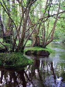
 River Blackwater at Eversley bridge | |
| Location | |
| Country | England |
| Counties | Hampshire, Surrey, Berkshire |
| Physical characteristics | |
| Source | |
| ⁃ location | Rowhill Nature Reserve, Aldershot, Hampshire |
| ⁃ elevation | 135 m (443 ft) |
| Mouth | River Loddon |
⁃ location | Berkshire |
| Length | 36 km (22 mi) |
| Discharge | |
| ⁃ location | Swallowfield |
| ⁃ average | 3.07 m3/s (108 cu ft/s) |
| ⁃ minimum | 0.48 m3/s (17 cu ft/s)(17 August 1953) |
| ⁃ maximum | 42.3 m3/s (1,490 cu ft/s)(17 September 1968) |
| Discharge | |
| ⁃ location | Farnborough |
| ⁃ average | 0.52 m3/s (18 cu ft/s) |
| Basin features | |
| Tributaries | |
| ⁃ left | Cove Brook, River Whitewater |
| ⁃ right | Wish Stream |
Naming
Although this article calls it the River Blackwater, Ordnance Survey maps, both ancient and modern, call it the Blackwater River. There is a small section to the west of Finchampstead which is called Long Water in both 1897 and on recent maps.[1] The final section from the Whitewater to the Loddon is known by alternative names. The Ordnance Survey 1:50,000 map calls it the Blackwater River, the 1:25,000 map calls it the Broadwater, and the 1:2500 map calls it the Blackwater River at both ends of this section, but the Broadwater in the middle.[2] This last option, with a small section of Broadwater in the middle where the river is somewhat wider, was also the convention in 1899.[3]
Blackwater Valley
The River Blackwater runs down the centre of the Blackwater Valley, which is maintained as an open space along the borders of the counties of Berkshire, Hampshire and Surrey. It runs for approximately 22.5 miles (36 km) from its source at Rowhill Nature Reserve near Aldershot in the south, northwards to Swallowfield where the river is joined by the River Whitewater and then joins the River Loddon. The Loddon eventually flows into the River Thames near Reading.
Although the lower reaches of the Blackwater are relatively rural, the upper reaches are heavily urbanised, with the river flowing through Aldershot, Farnborough, Camberley, Sandhurst and Yateley. Beneath the whole of the catchment there are chalk and greensand aquifers, but these are covered by a layer of impervious material, principally London clay. Some of the water of the Blackwater is provided by springs from these aquifers, but by far the largest component of the flow is the dischage from five major sewage treatment works on the upper reaches and two smaller ones on the lower reaches.[4] The springs are on the edge of the Bagshot Beds, and the water from this source is quite acidic. After flowing over the London clay deposits, the underlying geology is more permeable near the mouth, consisting of Bagshot and Bracklesham Beds.[5] In 1992, the five major sewage treatment works could discharge up to 74.4 Ml per day, and in summer months this accounted for around 85 per cent of the flow in the river above the confluence with the Whitewater.[6]
The river valley is characterised by large areas of river gravels, which have been quarried extensively since the 1950s, and continue to be so. This activity accounts for the large number of lakes in the valley, as old workings fill with water, and have been landscaped to provide amenities, such as country parks and locations for fishing and boating. A number of them are designated Sites of Special Scientific Interest (SSSI) because of their rich and diverse ecology.[4]
Although surrounded by urban development the Valley provides an important green corridor for local residents. As well as the Blackwater Valley SSSI and a small part of the Basingstoke Canal SSSI, three nature reserves within the Valley catchment and many other areas have been recognised for their ecological importance. The local planning authorities covering the Valley have designated 31 other areas as ‘Wildlife Sites’. As a result of an improvement programme, wildlife is returning, including the otter which has been absent for over 40 years, fishing stocks are improving and the construction of the long distance riverside path has opened up much of the riverbank.
A cycle route runs alongside the River Blackwater for most of its length. There is a running club named Blackwater Valley Runners who run there regularly.[7]
Route
River Blackwater | ||||||||||||||||||||||||||||||||||||||||||||||||||||||||||||||||||||||||||||||||||||||||||||||||||||||||||||||||||||||||||||||||||||||||||||||||||||||||||||||||||||||||||||||||||||||||||||||||||||||||||||||||||||||||||||||||||||||||||||||||||||||||||||||||||||||||||||||||||||||||||||||||||||||||||||||||||||||||||||||||||||||||||||||||||||||||||||||||||||||||||||||||||||||||||
|---|---|---|---|---|---|---|---|---|---|---|---|---|---|---|---|---|---|---|---|---|---|---|---|---|---|---|---|---|---|---|---|---|---|---|---|---|---|---|---|---|---|---|---|---|---|---|---|---|---|---|---|---|---|---|---|---|---|---|---|---|---|---|---|---|---|---|---|---|---|---|---|---|---|---|---|---|---|---|---|---|---|---|---|---|---|---|---|---|---|---|---|---|---|---|---|---|---|---|---|---|---|---|---|---|---|---|---|---|---|---|---|---|---|---|---|---|---|---|---|---|---|---|---|---|---|---|---|---|---|---|---|---|---|---|---|---|---|---|---|---|---|---|---|---|---|---|---|---|---|---|---|---|---|---|---|---|---|---|---|---|---|---|---|---|---|---|---|---|---|---|---|---|---|---|---|---|---|---|---|---|---|---|---|---|---|---|---|---|---|---|---|---|---|---|---|---|---|---|---|---|---|---|---|---|---|---|---|---|---|---|---|---|---|---|---|---|---|---|---|---|---|---|---|---|---|---|---|---|---|---|---|---|---|---|---|---|---|---|---|---|---|---|---|---|---|---|---|---|---|---|---|---|---|---|---|---|---|---|---|---|---|---|---|---|---|---|---|---|---|---|---|---|---|---|---|---|---|---|---|---|---|---|---|---|---|---|---|---|---|---|---|---|---|---|---|---|---|---|---|---|---|---|---|---|---|---|---|---|---|---|---|---|---|---|---|---|---|---|---|---|---|---|---|---|---|---|---|---|---|---|---|---|---|---|---|---|---|---|---|---|---|---|---|---|---|---|---|---|---|---|---|---|---|---|---|---|---|---|---|---|---|---|---|---|---|---|---|---|---|---|---|---|---|---|---|---|---|---|
| ||||||||||||||||||||||||||||||||||||||||||||||||||||||||||||||||||||||||||||||||||||||||||||||||||||||||||||||||||||||||||||||||||||||||||||||||||||||||||||||||||||||||||||||||||||||||||||||||||||||||||||||||||||||||||||||||||||||||||||||||||||||||||||||||||||||||||||||||||||||||||||||||||||||||||||||||||||||||||||||||||||||||||||||||||||||||||||||||||||||||||||||||||||||||||
The Blackwater rises as a series of springs on Rowhill Copse, a nature reserve to the south-west of Aldershot. The 55-acre (22 ha) site contains a range of habitats, and is on the site of a private estate which once produced timber and bricks.[8] The river heads in a south-easterly direction, passing under the railway line to Aldershot station, between two lakes, under Badshot Lea Road and past some more lakes, which form part of Tice's Meadow nature reserve. This was a hop farm from 1851 until 1958, after which 140 acres (57 ha) were quarried by Hanson Aggregates between 1998 and 2010. The site was adopted as a Site of Nature Conservation Interest (SNCI) in 2009, and was restored after quarrying stopped.[9] Beyond the reserve, the river sweeps round in a large loop to head northwards, and is joined by the A331, which follows the river valley for a considerable distance.[10]
The Aldershot sewage treatment works is located on the left bank, and during dry weather supplies more than half of the river's flow.[11] Willow Park Fishery is to the east of the river, which passes under an aqueduct carrying the Basingstoke Canal, and is then bordered by Lakeside Nature Reserve to the east and Gold Valley Lakes fishery to the west. The A331 road makes the first of several crossings over the river.[10] Further north is Hollybush Park, a sand quarry which was then used as a landfill site, and is now an attractive grassland with wild flowers.[12] The lakes to the north were the subject of a planning enquiry in 2020, to build 21 floating holiday homes and an equestrian centre.[13] The river is hemmed in by lakes, railways and roads, and is crossed by the railway line to Farnborough station.[10]
After junction 4 on the M3 motorway, the river is joined by Cove Brook, which starts as a series of streams near Farnborough Airport and flows northwards. For much of its route it is bordered by housing on both sides, but then passes beneath the North Downs railway line to reach the junction.[10] The tree-lined section immediately afterwards was once a gas works and railway sidings, but is now known as Blackwater Park, as far as the A30 road bridge.[14] The small town of Blackwater is on the left bank and Camberley sewage treatment works is on the right bank at York Town. This was the cause of a serious pollution incident in 2012, when a malfunction in the works resulted in partially treated effluent being discharged into the river, and contaminating the river for 1 mile (1.6 km) downstream. This resulted in fish within the Shepherds Meadow SSSI suffocating and dying. Thames Water upgraded part of the works after the incident.[15]
To the north of the bridge, the river is joined by the Wish Stream. This rises at Wishmoor Cross, in a danger area with restricted access, and flows to the south west along Wishmoor Bottom, a boggy valley which marks the border between Surrey and Berkshire. It is part of a Site of Special Scientific Interest (SSSI) because of its populations of Dartford warbler, nightjar and woodlark, and is a nationally important habitat for dragonfly and damselfly.[16] The Wish Stream then flows through the grounds of the Royal Military Academy Sandhurst,[17] entering Bathing Pool, and then passing through a series of engineered ponds and weirs, which create a significant obstacle to the movement of fish, to reach the Lower Lake. This is also supplied with water from the Upper Lake, located to the south of the Wish Stream. There is a large control structure at the outlet of the Lower Lake, which is totally impassable to fish, and then a series of high weirs again with no provision for the movement of fish.[18] Below the grounds of the Academy, the stream flows in a culvert under a car park for a retail outlet, and several more culverts under roads to reach the Blackwater.[19] The confluence used to be the point at which the counties of Berkshire, Hampshire and Surrey met, but when the Blackwater Valley road was being constructed in 1990, the Wish Stream was moved a short distance to the north to accommodate the roundabout that links the A30, A321 and A331 roads.[20]
The river then flows through Shepherd Meadows, an SSSI noted for the Black Poplar tree, and a variety of wild flowers, including Sneezewort, Knapweed, Betony, Meadowsweet and Great Burnet.[20] As the river curves to the west, it passes under the North Downs Line railway bridge, flows past Sandhurst sewage treatment works on the right bank and enters Trilakes Country Park. Former gravel pits flank the river on both sides, and as it passes the village of Finchampstead, the channel is briefly called Long Water. Soon it reaches New Mill, where there is a weir and sluice.[10] The mill was a corn mill in 1871[21] and produced animal feed unti the 1950s, when the building was sold.[22] The watermill and mill house are grade II listed, with parts of the buildings dating from the 15th century. They are now used as a restaurant, but the mill wheel, gears and machinery have been restored and can be seen working, encased behind glass screens.[23] The river follows the northern edge of Bramshill Plantation, 3,200 acres (13 km2) of woodland managed by the Forestry Commission. It is a Special Protection Area in view of the number of bird species to be found there, and also has large populations of damselflies, dragonflies and silver studded blue butterflies. Notable flora includes marsh clubmoss and pillwort.[24]
The river turns to the north-west, and is joined by the River Whitewater, flowing northwards from Greywell, near Greywell Tunnel, the present end of the Basingstoke Canal. As it approaches Swallowfield, the channel splits and there are weirs on both branches. They enter Swallowfield Park, a grade II listed park and gardens. The park was enclosed by King Edward III in 1354, and remained the property of the monarch until the late 16th century, after which is was privately owned until 1965.[25] The large country house was built in the late 17th century, was altered in 1820, and restored in the 1970s. The house and adjoining stable block are grade II* listed.[26] The main drive to the house crosses the river on a five-arched brick bridge, dating from the late 18th century.[27] The river continues through the park until it reaches the River Loddon.[10]
Ash Aqueduct
The Basingstoke Canal runs from the Greywell Tunnel at Greywell in the west to the River Wey in the east, and crosses the Blackwater Valley on an embankment in the village of Ash.[28] The River Blackwater used to flow through a brick culvert under the embankment,[29] but major reconstruction took place over the winter of 1994-95 as part of a project to route the A331 road along the river valley.[30] Because bats were known to roost in the culvert, a new home for them was built on a nearby island.[31] The central section of the embankment was then removed and replaced with a three-span aqueduct, with a centre span of 130 feet (40 m) and two side spans of 56 feet (17 m) each. The structure was built of post-tensioned concrete, using four cables on each side of the navigation channel, which were jacked apart until each was exerting a force of 820 tonnes to keep the concrete in compression.[32] In order to avoid the aqueduct piers, the river channel was diverted to run through the western side span, and a new course was constructed until the road had risen sufficiently for a box-section culvert to carry the river under the new road to rejoin its original route.[29] The new Ash Aqueduct affords views of the surrounding countryside. In the distance to the south is the Hog's Back, which runs between Farnham and Guildford, and is where the North Downs narrows.
Water Quality
The Environment Agency measure water quality of the river systems in England. Each is given an overall ecological status, which may be one of five levels: high, good, moderate, poor and bad. There are several components that are used to determine this, including biological status, which looks at the quantity and varieties of invertebrates, angiosperms and fish, and chemical status, which compares the concentrations of various chemicals against known safe concentrations. Chemical status is rated good or fail.[33]
The water quality of the Blackwater system was as follows in 2016.
| Section | Ecological Status | Chemical Status | Overall Status | Length | Catchment |
|---|---|---|---|---|---|
| Blackwater (Aldershot to Cove Brook confluence at Hawley)[34] | style="background: #ffd784; text-align: center;" | Poor | style="background: #7af58a; text-align: center;" | Good | style="background: #ffd784; text-align: center;" | Poor | 10.3 miles (16.6 km) | 24.34 square miles (63.0 km2) |
| Cove Brook[35] | style="background: #dd9393; text-align: center;" | Bad | style="background: #7af58a; text-align: center;" | Good | style="background: #dd9393; text-align: center;" | Bad | 4.4 miles (7.1 km) | 8.80 square miles (22.8 km2) |
| Blackwater (Hawley to Whitewater confluence at Bramshill)[36] | style="background: #ffff99; text-align: center;" | Moderate | style="background: #7af58a; text-align: center;" | Good | style="background: #ffff99; text-align: center;" | Moderate | 10.3 miles (16.6 km) | 27.26 square miles (70.6 km2) |
| Blackwater (Bramshill to River Loddon confluence at Swallowfield)[37] | style="background: #ffd784; text-align: center;" | Poor | style="background: #7af58a; text-align: center;" | Good | style="background: #ffd784; text-align: center;" | Poor | 1.8 miles (2.9 km) | 2.40 square miles (6.2 km2) |
Reasons for the quality being less than good include discharge from sewage treatment works; drainage from roads and transport infrastructure; contaminated land adjacent to the river; physical barriers such as weirs and impounding of the water which prevent the free migration of fish and other species; and the presence of the North American signal crayfish, an invasive species.
See also
- List of rivers in England
Bibliography
- Cumberlidge, Jane (2009). Inland Waterways of Great Britain (8th Ed.). Imray Laurie Norie and Wilson. ISBN 978-1-84623-010-3.CS1 maint: ref=harv (link)
- Eighteen, Brian (2000). "Watermills on the River Loddon". Wargrave Local History Society. Archived from the original on 14 January 2017. Retrieved 4 January 2012.CS1 maint: ref=harv (link)
- McEwan, Fergus (19 February 2015). "Thames Water fined for sewage spillage into Camberley river". Surrey Live. Archived from the original on 2 May 2015.CS1 maint: ref=harv (link)
- NRA (November 1992). "Blackwater River Catchment Management Plan" (PDF). National Rivers Authority. Archived (PDF) from the original on 20 June 2020.CS1 maint: ref=harv (link)
- Phillips, Jamie (23 April 2020). "Aldershot site identified for holiday camp". Surrey Live. Archived from the original on 30 April 2020.CS1 maint: ref=harv (link)
- WTT (July 2012). "Wish Stream – Royal Military Academy Sandhurst" (PDF). Wild Trout Trust. Archived (PDF) from the original on 19 June 2020.CS1 maint: ref=harv (link)
References
- Ordnance Survey, 1:2500 map, 1897; 1:25000 map, 2020
- Ordnance Survey, 1:50000, 1:25000 and 1:2500 maps, 2020
- Ordnance Survey, 1:2500 map, 1899
- NRA 1992, p. 2:2.
- NRA 1992, p. 2:6.
- NRA 1992, p. 3:14.
- http://www.bvrunners.org.uk
- "Rowhill Nature Reserve". Rushmoor Borough Council. Archived from the original on 1 January 2019.
- "Tice's Meadow: History". Tice's Meadow Bird Group. Archived from the original on 21 May 2019.
- Ordnance Survey, 1:2500 map
- "The performance of Aldershot STW and its effect on the River Blackwater". National Rivers Authority Thames Region. Archived from the original on 19 June 2020.
- "Hollybush and Hollybush Hill". Rushmoor Borough Council. Archived from the original on 13 November 2017.
- Phillips 2020.
- "Section 6 – M3 bridge to Blackwater Park". Blackwater Valley Path. Blackwater Valley Countryside Trust. Archived from the original on 19 June 2020.
- McEwan 2015.
- WTT 2012, p. 4.
- WTT 2012, p. 3.
- WTT 2012, pp. 8-9.
- WTT 2012, p. 10.
- "Section 7 – Blackwater Park to Swan Lane". Blackwater Valley Path. Blackwater Valley Countryside Trust. Archived from the original on 19 June 2020.
- Ordnance Survey, |1:2500 map, 1871
- Eighteen 2000.
- Historic England. "New Mill (1313122)". National Heritage List for England. Retrieved 18 June 2020.
- "Bramshill Block". Woodland Trust.
- Historic England. "Swallowfield Park (1000537)". National Heritage List for England. Retrieved 18 June 2020.
- Historic England. "Swallowfield Park and adjoining stable block (1313056)". National Heritage List for England. Retrieved 18 June 2020.
- Historic England. "Bridge at Swallowfield (1118064)". National Heritage List for England. Retrieved 18 June 2020.
- Cumberlidge 2009, p. 72.
- "Construction - Diverting the Blackwater River". The Ash Aqueduct. Basingstoke Canal. November 2001. Archived from the original on 18 June 2020.
- "Introduction - an Overview". The Ash Aqueduct. Basingstoke Canal. November 2001. Archived from the original on 20 December 2017.
- "Construction - Work begins". The Ash Aqueduct. Basingstoke Canal. November 2001. Archived from the original on 18 June 2020.
- "The Design". The Ash Aqueduct. Basingstoke Canal. November 2001. Archived from the original on 14 March 2016.
- "Glossary (see Biological quality element; Chemical status; and Ecological status)". Catchment Data Explorer. Environment Agency. 17 February 2016.
- "Blackwater (Aldershot to Cove Brook confluence at Hawley)". Catchment Data Explorer. Environment Agency.
- "Cove Brook". Catchment Data Explorer. Environment Agency.
- "Blackwater (Hawley to Whitewater confluence at Bramshill)". Catchment Data Explorer. Environment Agency.
- "Blackwater (Bramshill to River Loddon confluence at Swallowfield)". Catchment Data Explorer. Environment Agency.
External links
| Wikimedia Commons has media related to River Blackwater (River Loddon). |
| Main rivers |
|  |
|---|---|---|
| Canals and Navigations | ||
| Ordinary watercourses | ||
| Lakes, ponds and wetlands | ||
| Coast | ||
Categories: Rivers, Canals | ||
| Authority control |
|
|---|