River Test
The River Test is a river in Hampshire, England. It has a total length of 40 miles (64 km) and it flows through downland from its source near Ashe to its estuary at Southampton, where it converges with the River Itchen to form Southampton Water. In its upper reaches it is a chalk stream, and is used for fly fishing for trout.[2] Much of the river's course is followed by the Test Way.
| River Test | |
|---|---|
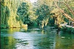 The Test downstream of Sadler's Mill, Romsey | |
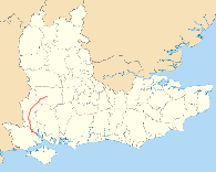 River Test highlighted in red, shown in South East England | |
| Location | |
| Country | England |
| Counties | Hampshire |
| Physical characteristics | |
| Source | |
| ⁃ location | Ashe, near Overton, Hampshire, United Kingdom |
| ⁃ coordinates | 51.2454°N 1.2392°W |
| ⁃ elevation | 90 m (300 ft) |
| Mouth | Southampton water |
⁃ location | Southampton, Hampshire, United Kingdom |
⁃ coordinates | 50.9251°N 1.4792°W |
⁃ elevation | 0 m (0 ft) |
| Site of Special Scientific Interest | |
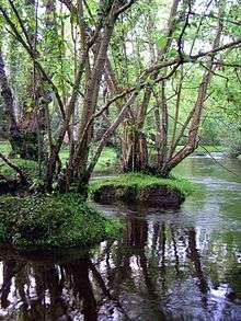
.jpg) River Test at Tufton | |
| Area of Search | Hampshire |
|---|---|
| Grid reference | SU 384 355[1] |
| Interest | Biological |
| Area | 438.0 hectares (1,082 acres)[1] |
| Notification | 1996[1] |
| Location map | Magic Map |

It is a 438-hectare (1,080-acre) biological Site of Special Scientific Interest.[1][3] It is part of Solent and Southampton Water Ramsar site[4] and Special Protection Area.[5]
Etymology
The river's name is believed to be Celtic in origin possibly related to the Welsh tres (tumult, commotion, contention, uproar) or trais (force, might in older Welsh).[6]
Course
The river rises near the village of Ashe, 10 km to the west of Basingstoke (at grid reference SU 532,498), and flows west through the villages of Overton, Laverstoke, and the town of Whitchurch, before joining with the Bourne Rivulet at Testbourne and turning in a more southerly direction. It then proceeds through the villages of Longparish and Middleton to Wherwell and Chilbolton, where the Rivers Dever and Anton join.[7]
From Chilbolton the river goes through the villages of Leckford, Longstock, Stockbridge and Houghton to Mottisfont and Kimbridge, where the River Dun joins the flow. From here the village of Timsbury is passed, then through the grounds of Roke Manor before reaching the town of Romsey. On the western edge of Romsey, Sadler's Mill, an 18th-century watermill, sits astride the River Test.[8]
South of Romsey, the river passes the country house of Broadlands, and then Nursling, once the site of a Roman bridge. Finally the river is joined by the River Blackwater and soon becomes tidal, widening out into a considerable estuary that is lined on its northern bank by the container terminals and quays of the Port of Southampton. The Test estuary then meets that of the River Itchen and the two continue to the sea as Southampton Water.[9]
Between Chilbolton and Redbridge, the river was once paralleled by the Andover Canal, which was itself converted to a railway in 1865, and then in turn abandoned. Most traces of the canal have disappeared, although the remains of a stretch can still be seen between Timsbury and Romsey.[10]
Ecology
This chalk stream has one of the richest fauna and flora of any lowland river in England. More than 100 species of flowering plant have been recorded along its banks and 232 invertebrate taxa in the river. It is also important for wetland birds, with breeding species including kingfishers, grey wagtails and little grebes.[11]
In literature
The river plays a part in Richard Adams' novel Watership Down.
When the Watership rabbits are pursued by an enemy force, one rabbit carries out a plan which leads to their successful escape down the Test on a punt. In the text, we are told that this plan would not have been possible on most rivers, but the Test's smooth-flowing, weed-free nature makes it an exception. The punt becomes lodged on a low bridge, and the surviving rabbits are forced to swim under the bridge to the riverbank.
Tributaries
The following are the named tributaries of the River Test, listed in order upstream from Southampton Water.[12]
- Tanners Brook
- Wimpson stream (historically, due to the extension of the docks it now merges with Tanners Brook just before it reaches the Test)[13]
- River Blackwater
- River Dun
- Wallop Brook
- River Anton
- River Dever
- Bourne Rivulet
- River Swift
See also
- Rivers of the United Kingdom
References
- "Designated Sites View: River Test". Sites of Special Scientific Interest. Natural England. Retrieved 18 May 2020.
- Environment Agency (2006). Fact file on the River Test. Retrieved 8 February 2006. Archived 8 April 2005 at the Wayback Machine
- "Map of River Test". Sites of Special Scientific Interest. Natural England. Retrieved 18 May 2020.
- "Designated Sites View: Solent and Southampton Water". Ramsar Site. Natural England. Retrieved 23 April 2020.
- "Designated Sites View: Solent and Southampton Water". Special Protection Areas. Natural England. Retrieved 23 April 2020.
- Breeze, Andrew (1998). "The name of the River Test" (PDF). Proceedings of the Hampshire Field Club & Archaeological Society. 53: 226–227. Retrieved 27 January 2017.
- Ordnance Survey (2004). OS Explorer Map 144 – Basingstoke, Alton & Whitchurch. ISBN 0-319-23606-4.
- Ordnance Survey (2004). OS Explorer Map 131 – Romsey, Andpoo ver & Test Valley. ISBN 0-319-23600-5.
- Ordnance Survey (2004). OS Explorer Map OL22 – New Forest. ISBN 0-319-23616-1.
- Andover Town Central (2000–2006). The Andover Canal Archived 6 July 2008 at the Wayback Machine. Retrieved 9 February 2006.
- "River Test citation" (PDF). Sites of Special Scientific Interest. Natural England. Retrieved 18 May 2020.
- Ordnance Survey (1995). OS Landranger Map 185 – Winchester and Basingstoke. ISBN 0-319-22185-7.
- Burgess, Lawrence (1982). The Streams and Watercourses Of Southampton. Friends of Old Southampton. p. 4.
| Wikimedia Commons has media related to River Test. |
| Main rivers |
|  |
|---|---|---|
| Canals and Navigations | ||
| Ordinary watercourses | ||
| Lakes, ponds and wetlands | ||
| Coast | ||
Categories: Rivers, Canals | ||
| Authority control |
|
|---|