Chichester Harbour
Chichester Harbour is a 3,733.5-hectare (9,226-acre) biological and geological Site of Special Scientific Interest (SSSI) west of Chichester in Hampshire and West Sussex.[1][2] The SSSI is part of Chichester Harbour Area of Outstanding Natural Beauty[3] and Solent Maritime Special Area of Conservation.[4] It is also part of Chichester and Langstone Harbours Ramsar site,[5] Special Protection Area[6] and Nature Conservation Review site, Grade I.[7] Part of it is a Geological Conservation Review site[8] and two areas are Local Nature Reserves.[9][10]
| Site of Special Scientific Interest | |
 | |
| Area of Search | Hampshire West Sussex |
|---|---|
| Grid reference | SU 765 016[1] |
| Interest | Biological Geological |
| Area | 3,733.5 hectares (9,226 acres)[1] |
| Notification | 1985[1] |
| Location map | Magic Map |
Description
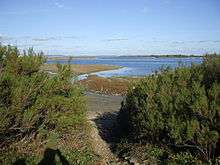
Chichester Harbour is a large natural harbour to the south west of the city of Chichester on the Solent. It is one of four natural harbours in that area of the coastline, the others being Portsmouth Harbour, Langstone Harbour and Pagham Harbour. The harbour and surrounding land is managed by Chichester Harbour Conservancy.[11] It is one of the few remaining undeveloped coastal areas in Southern England and remains relatively wild. Its wide expanses and intricate creeks are at the same time a major wildlife haven and among some of Britain's most popular boating waters.
The massive stretch of tidal flats and saltings are of outstanding ecological significance. Very large populations of wildfowl and waders use the mudflats feeding on the rich plant life and the huge populations of intertidal invertebrates. More than 7,500 Brent geese overwinter on the intertidal mud-land and adjacent farmland and around 55,000 birds reside in or visit the Harbour throughout the year.[12]
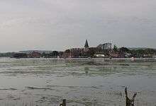
The harbourside villages are: West Wittering, West Itchenor, Birdham, Dell Quay, Fishbourne, Bosham, Chidham, Prinsted, Thorney Island, Emsworth, Langstone and Northney. The nearest towns are Havant, Chichester and Hayling Island. The harbour lowlands contain high quality arable farmland. Boatyards, marinas and commercial fishing are important elements of the local economy.
This is one of the south coast's most popular sailing waters with as many as 12,500 craft regularly using the harbour, with competitive racing taking place among the 14 sailing clubs of the Chichester Harbour Federation.[13] The villages, sea walls and footpaths are a popular leisure area for residents and tourists alike.
Set up by Act of Parliament in 1971, Chichester Harbour Conservancy has the duty to conserve, maintain and improve the harbour and amenity area for recreation, natural conservation and natural beauty. As well as being the statutory harbour authority, the Conservancy manages the Area of Outstanding Natural Beauty (AONB).[11]
To the south west of the entrance to Chichester Harbour is Chichester Bar, a shallow spit which can present a significant navigation hazard at all states of the tide. The entrance to the harbour is deep with a fast tidal stream and to the east of the main harbour entrance channel is a gravel bank known as The Winner.
The east side of the harbour entrance is an area of geographical, recreational and conservation interest known as East Head. It is a large sand dune linked to land by a narrow area known as The Hinge. In recent years The Hinge has been breached by several storms and then repaired. There is much debate about whether and how it should continue to be repaired.
The western boundary with Langstone Harbour is defined by a historic causeway known as the wade way, once the principal access from Hayling Island to the mainland, but since bisected by a deep channel for the Portsmouth and Chichester Canal in the 1820s, and no longer safely traversable.
Chichester Harbour has three main channels. The Emsworth Channel, the Thorney Channel and the Chichester Channel, which also branches off into the Bosham Lake and Itchenor Reach.
Biology and geology
The harbour has diverse habitats, including intertidal mudflats, shingle, saltmarsh, sand dunes, marshes and woodland. The mudflats provide feeding grounds for internationally important numbers of ringed plovers, grey plovers, redshanks, black-tailed godwits, dunlins, sanderlings, curlews and greenshanks. There are geologically important sand dunes and shingles at East Head and east of Langstone.[14]
Recreation
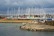
Chichester Harbour is used for a wide variety of sailing, including dinghy racing; it is the venue for the 'Itchenor Gallon' race for the International 14.[15] There are several yacht marinas. It is also used for fishing.
Harbour tours depart year round from Itchenor in either a traditional boat or in Solar Heritage, a solar powered boat. During the summer regular trips depart from Emsworth on Solar Heritage and on the Victorian oyster boat Terror.
There is a small dory that operates as a ferry service between Itchenor and Bosham.
The harbour is a very popular area for birdwatching; guided bird walks and boat trips are offered during the winter months by Chichester Harbour Conservancy.
There is a network of footpaths for walkers and a cycle route from Chichester to West Wittering which passes through harbour countryside.
West Wittering Beach and East Head is the only sandy beach on the West Sussex coast and is a popular family and tourist destination on warm weekends.

See also
References
- "Designated Sites View: Chichester Harbour". Sites of Special Scientific Interest. Natural England. Retrieved 20 April 2019.
- "Map of Chichester Harbour". Sites of Special Scientific Interest. Natural England. Retrieved 20 April 2019.
- "Landscape". Chichester Harbour Conservancy. Retrieved 20 April 2019.
- "Designated Sites View: Solent Maritime". Special Areas of Conservation. Natural England. Retrieved 6 April 2019.
- "Designated Sites View: Chichester and Langstone Harbours". Ramsar Site. Natural England. Retrieved 6 April 2019.
- "Designated Sites View: Chichester and Langstone Harbours". Special Protection Areas. Natural England. Retrieved 6 April 2019.
- Ratcliffe, Derek, ed. (1977). A Nature Conservation Review. 2. Cambridge, UK: Cambridge University Press. pp. 3–4. ISBN 0521 21403 3.
- "East Head (Chichester Harbour) (Coastal Geomorphology of England)". Geological Conservation Review. Joint Nature Conservation Committee. Retrieved 6 April 2019.
- "Designated Sites View: Nutborne Marshes". Local Nature Reserves. Natural England. Retrieved 6 April 2019.
- "Designated Sites View: Pilsey Island". Local Nature Reserves. Natural England. Retrieved 6 April 2019.
- "Chichester Harbour Conservancy". Retrieved 12 November 2014.
- http://www.landscapesforlife.org.uk/about-aonbs/visit-aonbs/chichester-harbour-aonb/
- "Chichester Harbour Federation". Retrieved 12 November 2014.
- "Chichester Harbour citation" (PDF). Sites of Special Scientific Interest. Natural England. Retrieved 20 April 2019.
- "International 14 Gallon Trophy at Itchenor Sailing Club". Yachts & Yachting. Retrieved 12 November 2014.
| Wikimedia Commons has media related to Chichester Harbour. |
External links
| East of England |  | |
|---|---|---|
| East Midlands | ||
| North East | ||
| North West | ||
| South East |
| |
| South West |
| |
| West Midlands | ||
| Yorkshire and Humber | ||
| ||
| Main rivers |
|  |
|---|---|---|
| Canals and Navigations | ||
| Ordinary watercourses | ||
| Lakes, ponds and wetlands | ||
| Coast | ||
Categories: Rivers, Canals | ||