Ria of Ferrol
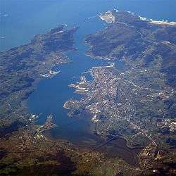
The Ria of Ferrol (or bay of Ferrol; Spanish and Galician: ría de Ferrol) is a ria in Galicia, Spain, the saline estuary of the Xuvia River. Located in the province of A Coruña, in the northwestern end of the Iberian Peninsula, it forms along the rías of A Coruña, Ares and Betanzos the gulf known as Portus Magnus Artabrorum in Roman times.[1] An important harbour, it became a base of the Spanish Navy during the Hapsburg dynasty, with the forts of San Felipe and La Palma watching over the in and out of the ria.[2] Bordered by the municipalities of Ferrol, Narón, Neda, Fene, Mugardos,[2] it stands out among the Galician rias in terms of the degree of alteration caused by human activities.[3] Also featuring nonetheless a rich sealife, the bay of Ferrol (itself included within the so-called "Rías Altas") is exploited to obtain seafood, chiefly varieties of clam and cockle.[4]
| Ria of Ferrol | |
|---|---|
 | |
| Coordinates | 43.4734°N 8.21851°W |
| Type | Ria |
| River sources | Xuvia River |
| Ocean/sea sources | Atlantic Ocean |
| Basin countries | Spain |
| Settlements | Ferrol, Narón, Neda, Fene, Mugardos |
References
- Troncoso, J.S; Urgorri, V (1993). "Datos sedimentológicos y macrofauna de los fondos infralitorales de sustrato blanco de la Ría de Ares y Betanzos (Galicia, España)". Nova Acta Científica Compostelana (Bioloxía) (4): 153.
- "Ría de Ferrol, histórica base de la Armada desde la dinastía de los Austrias". El Correo Gallego. 23 June 2013.
- Moreira, Juan; Díaz-Agras, Guillermo; Candás, María; Tato, Ramiro; Besteiro, Celia; Urgorri, Victoriano (2012). "Monitoring of subtidal mollusc assemblages in a highly urbanized environment: the Ría de Ferrol (Galicia, NW Iberian Peninsula)" (PDF). Revista de Investigación Marina: 361.
- "Actividad económica en Ferrolterra y área de influencia" (PDF). Ferrolterra. p. 23.