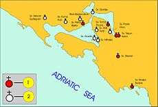
Bay of Kotor
The Bay of Kotor (Serbian and Montenegrin: Бока Которска / Boka Kotorska), also known as the Boka,[1] is the winding bay of the Adriatic Sea in southwestern Montenegro and the region of Montenegro concentrated around the bay.
Bay of Kotor Boka Kotorska Бока Которска | |
|---|---|
Geographic region of Montenegro | |
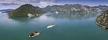
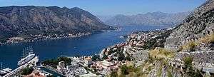
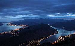 View over Bay of Kotor | |
 | |
| Country | |
| Municipalities | Kotor, Herceg Novi, Tivat |
| Area | |
| • Total | 616 km2 (238 sq mi) |
| Population | |
| • Total | 67,496 |
| Official name | Natural and Culturo-Historical Region of Kotor |
| Criteria | Cultural: i, ii, iii, iv |
| Reference | 125 |
| Inscription | 1979 (3rd session) |
| Area | 14,600 ha |
| Buffer zone | 36,491 ha |
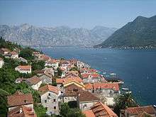
The bay has been inhabited since antiquity. Its well-preserved medieval towns of Kotor, Risan, Tivat, Perast, Prčanj and Herceg Novi, along with their natural surroundings, are major tourist attractions. The Natural and Culturo-Historical Region of Kotor was designated a UNESCO World Heritage Site in 1979. Its numerous Orthodox and Catholic churches and monasteries attract numerous religious and cultural pilgrims.
Geography
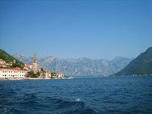
The bay is about 28 kilometres (17 mi) long with a shoreline extending 107.3 kilometres (66.7 mi). It is surrounded by two massifs of the Dinaric Alps: the Orjen mountains to the west, and the Lovćen mountains to the east. The narrowest section of the bay, the 2,300-metre (7,500 ft) long Verige Strait, is only 340 metres (1,120 ft) wide at its narrowest point.[2] The bay is a ria of the vanished Bokelj River, which used to flow from the high mountain plateaus of Mount Orjen.
The bay is composed of several smaller broad bays, united by narrower channels. The bay inlet was formerly a river system. Tectonic and karstification processes led to the disintegration of this river. After heavy rains, the waterfall of Sopot spring at Risan appears, and Škurda, another well-known spring, runs through a canyon from Lovćen.
The outermost part of the bay is the Bay of Tivat. On the seaward side is the Bay of Herceg Novi, at the main entrance to the Bay of Kotor. The inner bays are the Bay of Risan to the northwest and the Bay of Kotor to the southeast.
The Verige Strait represents the bay's narrowest section and is located between Cape St. Nedjelja and Cape Opatovo; it separates the inner bay east of the strait from the Bay of Tivat.
Climate
The Bay lies within the Mediterranean and northwards the humid subtropical climate zone, but its peculiar topography and high mountains make it one of the wettest places in Europe, with Europe's wettest inhabited areas (although certain Icelandic glaciers are wetter[3]). The littoral Dinarids and the Prokletije mountains receive the most precipitation, leading to small glaciers surviving well above the 0 °C (32 °F) mean annual isotherm. November thunderstorms sometimes drop large amounts of water. By contrast, in August the area is frequently completely dry, leading to forest fires. With a maximum discharge of 200 m3/s (7,100 cu ft/s), one of the biggest karst springs, the Sopot spring, reflects this seasonal variation. Most of the time it is inactive but after heavy rain a waterfall appears 20 metres (66 ft) above the Bay of Kotor.
| Station | Height [m] | Type | Character | Precipitation [mm] | Snow |
|---|---|---|---|---|---|
| Veliki kabao | 1894 | D | perhumid Mediterranean snowclimate | c. 6250 | ap. 140 days |
| Crkvice | 940 | Cfsb | (fs= without summerdryness), perhumid Mediterranean mountain climate | 4926 | 70 days |
| Risan | 0 | Cs’’a | (s’’= double winter rain season), perhumid Mediterranean coast climate | 3500 | 0.4 days |
*classification scheme after Köppen
Two wind systems have ecological significance: Bora and Jugo. Strong cold downslope winds of the Bora type appear in winter and are most severe in the Bay of Risan. Gusts reach 250 km/h (160 mph) and can lead to a significant temperature decline over several hours with freezing events. Bora weather situations are frequent and sailors study the mountains as cap clouds indicate an imminent Bora event. Jugo is a warm humid wind and brings heavy rain. It appears throughout the year but is usually concentrated in autumn and spring.
Monthly and yearly precipitation ranges:
| Station | Period | Height [m] | I | II | III | IV | V | VI | VII | VIII | IX | X | XI | XII | I-XII [mm/m²a] |
|---|---|---|---|---|---|---|---|---|---|---|---|---|---|---|---|
| Herceg Novi | 1961–1984 | 40 | 230 | 221 | 183 | 135 | 130 | 73 | 28 | 45 | 160 | 181 | 326 | 262 | 1974 |
| Risan | 1961–1984 | 40 | 405 | 342 | 340 | 235 | 153 | 101 | 66 | 123 | 188 | 295 | 423 | 434 | 3105 |
| Grahovo | 1961–1984 | 710 | 351 | 324 | 305 | 251 | 142 | 94 | 55 | 103 | 202 | 416 | 508 | 473 | 3224 |
| Podvrsnik | 1961–1984 | 630 | 407 | 398 | 367 | 305 | 151 | 101 | 77 | 132 | 238 | 465 | 593 | 586 | 3820 |
| Vrbanj | 1961–1984 | 1010 | 472 | 390 | 388 | 321 | 181 | 104 | 70 | 122 | 224 | 369 | 565 | 536 | 3742 |
| Knežlaz | 1961–1984 | 620 | 547 | 472 | 473 | 373 | 207 | 120 | 72 | 136 | 268 | 400 | 629 | 661 | 4358 |
| Crkvice | 1961–1984 | 940 | 610 | 499 | 503 | 398 | 198 | 135 | 82 | 155 | 295 | 502 | 714 | 683 | 4774 |
| Ivanova Korita | 1960–1984 | 1350 | 434 | 460 | 742 | 472 | 128 | 198 | 74 | 46 | 94 | 300 | 694 | 972 | 4614 |
| Goli vrh | 1893–1913 | 1311 | 271 | 286 | 307 | 226 | 188 | 148 | 75 | 70 | 215 | 473 | 415 | 327 | 3129 |
| Jankov vrh | 1890–1909 | 1017 | 424 | 386 | 389 | 346 | 212 | 124 | 55 | 58 | 202 | 484 | 579 | 501 | 3750 |
Hydrology
- Hydrologic system: karst hydrology ca. 4000 km², Sopot, Škurda, submerged sources
- Water area: 87 km²
- Max depth: 60 m
- Average depth: 27.3 m
- Water content:24,12306 km³ (ca. 2.4 mrd m³)
- Highest point: Orjen (1894 m)
- Lowest point: sea surface (0 m)
- Length: 28,13 km
- Widest point: 7 km
- Narrowest point: || 0.3 km
History
Middle Ages
The Sklavenoi, South Slavs, settled in the Balkans in the 6th century.[4][5] The Serbs, mentioned in the Royal Frankish Annals of the mid-9th century, controlled a great part of Dalmatia ("Sorabos, quae natio magnam Dalmatiae partem obtinere dicitur").[6][7]Constantine VII Porphyrogennetos in De Administrando Imperio mentione that from Croats who came to Dalmatia one part is separated and take rule in Illyricum (Roman province).[8] The Slavic, Serbian tribes, consolidated under the Vlastimirović dynasty (610–960). The two principalities of Doclea and Travunia were roughly adjacent at Boka. As elsewhere in the Balkans, Slavs mixed with the Roman population of these Byzantine coastal cities. The Theme of Dalmatia was established in the 870s. According to De Administrando Imperio (ca. 960), Risan was part of Travunia, a Serbian principality ruled by the Belojević family.
After the Great Schism of 1054, the coastal region was under both Churches. In 1171, Stefan Nemanja sided with the Venetian Republic in a dispute with the Byzantine Empire. The Venetians incited the Slavs of the eastern Adriatic littoral to rebel against Byzantine rule and Nemanja joined them, launching an offensive towards Kotor. The Bay was thenceforth under the rule of the Nemanjić dynasty. In 1195 Nemanja and his son Vukan constructed the Church of Saint Luka in Kotor. In 1219 Saint Sava founded the seat of the Eparchy of Zeta on Prevlaka,[9] one of the eparchies of the Serbian Orthodox Church. Due to its protected location, Kotor became a major city for the salt trade. The area flourished during the 14th century under the rule of Serbian emperor Dušan "The Mighty" who, notorious for his aggressive law enforcement, made the Bay of Kotor a particularly safe place for doing business.[10]
The city of Kotor was under Nemanjić rule until 1371. It was followed by a period of frequent political changes in the region. Local lords from Vojinović and Balšić noble families fought over the influence in the region. Since 1377, northern parts of the Bay region came under the rule of Tvrtko I Kotromanić, who proclaimed himself King of the Serbs and Bosnia. For several years (1385-1391), the city of Kotor also recognized the suzerainty of the Kingdom of Bosnia. After 1391, it gained political independence, and functioned as a city-state until 1420. Its merchant fleet and importance gradually increased, but so was the interest of the powerful Republic of Venice for the city and the bay region. From 1405 to 1412, the First Scutari War was fought in the region.
Venetian rule (1420–1797)
In 1420, the city of Kotor recognized the Venetian rule,[11] marking the beginning of an era that would last until 1797. Northern parts of the Bay region still remained under the Kingdom of Bosnia, while southern parts were controlled the Lordship of Zeta, followed by the Serbian Despotate. In the meanwhile, the Second Scutari War was fought in the region, resulting in the peace treaties of 1423 and 1426.
By the middle of the 15th century, northern parts of the Bay region became incorporated into the Duchy of Saint Sava. In 1482, Ottomans took the city of Novi, establishing their rule in the northern parts of the Bay area. Under Ottoman rule, those regions were attached to the Sanjak of Herzegovina. The Ottoman possessions in the Bay region were retaken at the end of the 17th century and the whole area became part of the Venetian Republic, within the province called the Albania Veneta. Until the 20th century the difference between the two parts was visible because the former Ottoman part had an Orthodox majority, while the part that was under Venetian rule had a Catholic majority.[12]
The town of Perast had difficult moments in 1654 when the Ottomans attacked, retaliating against Bokeljs who had sunk an Ottoman ship. The Bokeljs' successful defence of Perast and Boka received attention all over Europe. It attracted Petar Zrinski, a statesman in Europe who had fought dramatic battles with the Turks. During his three-day sojourn in Perast he presented his legendary sword to the town in recognition for their efforts to defend their homeland, and to stop the Ottoman Empire.
In 1669, according to Andrija Zmajević, hajduks of the Bay[13] wished to build a church, but were denied due to Zmajević's intervention on the providur of Kotor and captain of Perast.[14] Turkish travel writer Evliya Çelebi visits the Bay of Kotor and mentione Croats who live in the Herceg Novi[15]
Modern history
By the Treaty of Campo Formio (1797), the Bay region came under the Habsburg rule. By the Treaty of Pressburg (1805), the region was set to be transferred to the French rule, but that was effectively achieved only after the Peace of Tilsit (1807). Under the French rule, the Bay region was included in the Napoleonic Kingdom of Italy and later in the Illyrian provinces,[16] which were a part of the French Empire. The region was later conquered by Montenegro with Russian help by Prince-Bishop Petar I Petrović Njegoš and, in 1813, a union of the bay area with Montenegro was declared. In 1815, the bay was annexed by the Austrian Empire and was included in the province of Dalmatia (part of Cisleithania since 1867). In 1848, when the numerous revolutions sparked in the Austrian Empire, an Assembly of the Gulf of Kotor was held sponsored by Petar II Petrović-Njegoš of Montenegro, to decide on the proposition of Boka's unification with Croatian Ban Josip Jelačić in an attempt to unite Dalmatia, Croatia and Slavonia under the Habsburg crown.
The Kingdom of Montenegro attempted to take the bay during World War I. It was bombarded from Lovćen, but by 1916 Austria-Hungary had defeated Montenegro. During Austro-Hungarian rule majority of people participated on retreat with Serbian army through Albania. On 7 November 1918 the Serbian army entered the bay. Within a month, the Kingdom of Serbs, Croats, and Slovenes was formed and was renamed as Yugoslavia in 1929. The bay was a municipality of Dalmatia until it was re-organized into smaller districts in 1922. It was incorporated into the Zeta Area and from 1939 Zeta Banate.
According to the 1910 census, the bay had 40,582 inhabitants, of whom 24,794 were Orthodox Christians and 14,523 Catholics.
The Bay region was occupied by the Italian Army in April 1941 and was included in the Italian Governatorato di Dalmazia until September 1943. Since 1945, it has been part of the Republic of Montenegro.
Culture
Most of the region's inhabitants are Orthodox Christians, declaring themselves on census forms of either Montenegrins or Serbians, while a minority are Croatians. The Bay region is under the protection of UNESCO due to its rich cultural heritage.
The Boka region has a long naval tradition and has harbored a strong naval fleet since the Middle Ages. The fleet peaked at 300 ships in the 18th century, when Boka was a rival to Dubrovnik and Venice.
On the landward side, long walls run from the fortified old town of Kotor to the castle of Saint John, far above; the heights of the Krivošije, a group of barren plateaus in Mount Orjen, were crowned by small forts.
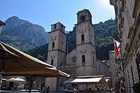
The shores of the bay Herceg Novi house the Orthodox convent of St. Sava near (Savina monastery) standing amid surrounding gardens. It was founded in the 16th century and contains many specimens of 17th century silversmiths' work. 12.87 km east of Herceg Novi, there is a Benedictine monastery on a small island opposite Perast (Perasto). Perast itself was for a time an independent state in the 14th century.
Demographics
The Bokelj (Бокељ) people (pl. Бокељи, Bokelji) are the inhabitants of the Boka Kotorska (hence the name) and adjacent regions (near the towns of Kotor, Tivat, Herceg Novi, Risan, Perast).[17] They are an ethnic South Slavic community, many of whom nationally identify as Montenegrin, Serb or Croat. Most are Eastern Orthodox, while some are Roman Catholics.
According to the 2011 Montenegro census, the total population of Boka was 67,456. When it comes to ethnic composition, in 2011 there were 26,435 (39.2%) Serbs, 26,108 (38.7%) Montenegrins, and 4,519 (6.7%) Croats. [18]
|
|
|
|
Notable people
- Matija Zmajević – shipbuilder
- Andrija Paltašić – typographer
- Nikola Modruški – bishop
- Krsto Čorko[19] – naval captain
- Petar Želalić[20] – naval captain
- Ivan Visin – sailor
- Stjepan Mitrov Ljubiša – politician
- Rambo Amadeus – singer
- St. Leopold Bogdan Mandić (1866–1942)
- blessed Ozana Kotorska (also known as Katarina Kosić, 1493–1565)
- Giovanni Bona de Boliris
Gallery
 Saint-George and Our-Lady-of-the-Reef, two islands off Perast.
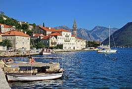 Town of Perast, Kotor Municipality
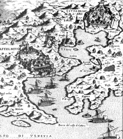
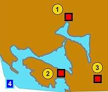 Bay of Kotor and Illyrian fortresses on the hills 1)Risan 2)Gosici 3)Kremalj (Mirac)
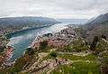 Kotor bay from St John Castle.
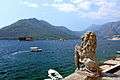 Stone lion and the Bay of Kotor. Perast, Montenegro.
 The ancient fortifications of Kotor
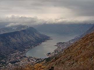 Panorama of the Bay of Kotor
See also
- Albania Veneta
- Montenegrin Littoral
References
- "Welcome to Bay of Kotor". Lonely Planet. Retrieved 14 January 2020.
- D Magaš. "Natural-Geographic Characteristics of the Boka Kotosdka Area As the Basis of Development". Geoadria Vol. 7 No. 1, Croatian Geographical Society and University of Zadar Department of Geography, Zadar, 2002, pp. 53.
- "Late Holocene Glacial History of Sólheimajökull, Southern Iceland" (PDF). Archived from the original (PDF) on 2014-03-20.
- Hupchick, Dennis P. The Balkans: From Constantinople to Communism. Palgrave Macmillan, 2004. ISBN 1-4039-6417-3
- Rastko.org, Arheologija 13047
- Serbian studies, Volumes 2–3, p. 29
- De originibus Slavicis, Volume 1 By Johann Christoph von Jordan, p. 155
- Lujo Margetić, Konstantin Porfirogenet i vrijeme dolaska Hrvata, Vol. 8, 1977. https://hrcak.srce.hr/83642 #page=8
- Popović 2002, p. 173.
- Rick Steves Snapshot Dubrovnik by Rick Steves and Cameron Hewitt
- Ćirković 2004, p. 92.
- Ćirković 2004, p. 185.
- Miloš Milošević (1988). Hajduci u Boki Kotorskoj 1648–1718. CANU.
- Marko Jačov (1992). Le Missioni cattoliche nei Balcani durante la Guerra di Candia (1645–1669). Biblioteca apostolica vaticana. pp. 709–. ISBN 978-88-210-0638-8.
- http://www.montenegrina.net/pages/pages1/istorija/odcrnojevica_dopetrovica/kako_je_evlija_celebija_pisao_o_hn_m_bojanic.htm
- Ćirković 2004, p. 187.
- "[Projekat Rastko – Boka] Simo Matavulj – Boka i Bokelji". rastko.org.rs. Archived from the original on 24 September 2015. Retrieved 31 May 2015.
- "Census 2011 data - Municipalities". monstat.org. Statistical Office of Montenegro.
- "Slavni "Kapetani Boke kotorske"". Radio DUX. Retrieved 31 May 2015.
- Petar Želalić famous naval captain, from Boka Kotorska Archived April 22, 2014, at the Wayback Machine
Literature
- Ćirković, Sima (2004). The Serbs. Malden: Blackwell Publishing.CS1 maint: ref=harv (link)
- Fine, John Van Antwerp Jr. (1991) [1983]. The Early Medieval Balkans: A Critical Survey from the Sixth to the Late Twelfth Century. Ann Arbor, Michigan: University of Michigan Press.CS1 maint: ref=harv (link)
- Fine, John Van Antwerp Jr. (1994) [1987]. The Late Medieval Balkans: A Critical Survey from the Late Twelfth Century to the Ottoman Conquest. Ann Arbor, Michigan: University of Michigan Press.CS1 maint: ref=harv (link)
- Popović, Svetlana (2002). "The Serbian Episcopal sees in the thirteenth century (Српска епископска седишта у XIII веку)". Старинар (51: 2001): 171–184.CS1 maint: ref=harv (link)
- Boka kotorska: Etnički sastav u razdoblju austrijske uprave (1814.-1918. g.), Ivan Crkvenčić, Antun Schaller, Hrvatski geografski glasnik 68/1, 51–72 (2006)
| Wikimedia Commons has media related to Bay of Kotor. |
|  | |