Rhenen
Rhenen (![]()
Rhenen | |
|---|---|
City and Municipality | |
 The Cunera Church in Rhenen | |
 Flag  Coat of arms | |
.svg.png) Location in Utrecht | |
| Coordinates: 51°58′N 5°34′E | |
| Country | Netherlands |
| Province | Utrecht |
| Government | |
| • Body | Municipal council |
| • Mayor | Hans van der Pas (PvdA) |
| Area | |
| • Municipality | 43.76 km2 (16.90 sq mi) |
| • Land | 42.08 km2 (16.25 sq mi) |
| • Water | 1.68 km2 (0.65 sq mi) |
| Elevation | 43 m (141 ft) |
| Population (January 2019)[4] | |
| • Municipality | 20,004 |
| • Density | 475/km2 (1,230/sq mi) |
| Demonym(s) | Rhenenaar |
| Time zone | UTC+1 (CET) |
| • Summer (DST) | UTC+2 (CEST) |
| Postcode | 3910–3922 |
| Area code | 0317, 0318 |
| Website | www |

Directly to the east of the built-up area lies the Grebbeberg, a hill with a top elevation of about 50 metres (160 ft).
History
Before 1900
Rhenen received city rights probably between 1256 and 1258.[5][6] In 1346, the bishop of Utrecht ordered the construction of a defensive wall around the city, which was important because it lay near the border with Guelders. Although for some time the town collected toll from ships on the Rhine, it has never had a harbour. The three city gates were demolished in 1840. Small fragments of the wall remain.
The town is also famous for the Cunera Church, parts of which date back to the 15th century. Containing the relics of Saint Cunera, it attracted many pilgrims. Legend has it that Cunera was buried on a nearby hill now called the Cuneraheuvel. The church's tower was built between 1492 and 1531.
In 1621, a palace was constructed at Rhenen for the ousted Frederick V. It was demolished in 1812.
World War II
Part of the center of Rhenen, which was located near the defensive Grebbelinie (Grebbe line), was destroyed during the German attack on the Netherlands in May 1940. Part of the reconstruction took place during the war. In 1945, the town was damaged again during the liberation of the country from German occupation.
Many or all of the Dutch soldiers who were killed by the Germans near Rhenen lie buried at the Erebegraafplaats (Cemetery of Honor), located along the Grebbeweg (N 225) near the top of the Grebbeberg. Across the road is an important war monument with a poem by J.C. Bloem.
In 2008 Rhenen celebrated its 750th anniversary.
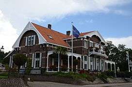
Main sights

- Ouwehands Dierenpark, a zoo, founded in 1932.
- The Cunera Church, a late-Gothic hall-church, built between 1492–1531.
- Modern Roman Catholic church Gedachteniskerk (Rhenen), built between 1958–1959.
- Building 'De Brakke' from 1787.
- Ruins of the 14th century Medieval defensive wall.
- The Binnenmolen (Rhenen), a round gristmill from 1893.
- The Prattenburg estate.
- Military War Cemetery Grebbeberg, a military cemetery on the Grebbeberg.
Transport
Notable people
- Jacobus Tollius (1633–1696) a Dutch classicist
- Jacob Nienhuys (1836–1927) founded the tobacco producer Deli Company in Sumatra
- Touriya Haoud (born 1977) a Dutch actress, model and singer who lives in Los Angeles[7]
- Lisa van Viegen (born 1978) stage name iET, a Dutch singer-songwriter and multi-instrumentalist.
- Sport
- Remy Reynierse (born 1961) is a former football player with 312 club caps, current coach at Sheffield Wednesday F.C.
- Eelco Uri (born 1973) a Dutch male former water polo player, competed in the 1966 and 2000 Summer Olympics
- Giedo van der Garde (born 1985) a Dutch racing driver
- Bibiane Schoofs (born 1988) a Dutch professional tennis player
- Madelein Meppelink (born 1989) a Dutch beach volleyball player, competed in the 2012 and 2016 Summer Olympics
Gallery
 Houses in Rhenen with characteristic wooden ornaments
 Haven van Rhenen
 View of Rhenen, Jan Van Goyen, 1656
 Pandasia Ouwehands Dierenpark
 Straatbeeld, Rhenen
 Gezicht op Rhenen
.jpg) Rhenen, panoramio
Rhenen, panoramio Rhenen, Frederik van de Paltshof Poort
References
- "Wat is en doet het college van B en W?" (in Dutch). Gemeente Rhenen. Retrieved 12 September 2017.
- "Kerncijfers wijken en buurten" [Key figures for neighbourhoods]. CBS Statline (in Dutch). CBS. 2 July 2013. Retrieved 12 March 2014.
- "Postcodetool for 3911MG". Actueel Hoogtebestand Nederland (in Dutch). Het Waterschapshuis. Retrieved 9 April 2014.
- "Bevolkingsontwikkeling; regio per maand" [Population growth; regions per month]. CBS Statline (in Dutch). CBS. 1 January 2019. Retrieved 1 January 2019.
- Kolman C., et al. (1996). Monumenten in Nederland: Utrecht. Zwolle: Waanders Uitgevers. ISBN 90-400-9757-7.
- Ph. J. van Dael, 'Over het Rhenense stadsrecht en het Rhenense (burger)zegel', in Oud Rhenen, 2002 no. 2, p. 5-38.
- IMDb Database retrieved 14 December 2019
External links
![]()
Places adjacent to Rhenen | ||||||||||
|---|---|---|---|---|---|---|---|---|---|---|
| ||||||||||
Municipalities of Utrecht | ||
|---|---|---|
 | ||
| ||
| Authority control |
|
|---|