De Ronde Venen
De Ronde Venen (![]()
De Ronde Venen | |
|---|---|
 Vinkeveen town centre | |
 Flag Coat of arms | |
.svg.png) Location in Utrecht | |
| Coordinates: 52°12′N 4°52′E | |
| Country | Netherlands |
| Province | Utrecht |
| Established | 1 January 1989 |
| Government | |
| • Body | Municipal council |
| • Mayor | Maarten Divendal (PvdA) |
| Area | |
| • Total | 116.98 km2 (45.17 sq mi) |
| • Land | 100.77 km2 (38.91 sq mi) |
| • Water | 16.21 km2 (6.26 sq mi) |
| Elevation | −2 m (−7 ft) |
| Population (January 2019)[4] | |
| • Total | 44,059 |
| • Density | 437/km2 (1,130/sq mi) |
| Time zone | UTC+1 (CET) |
| • Summer (DST) | UTC+2 (CEST) |
| Postcode | Parts of 1300, 1400 and 3600 ranges |
| Area code | 0294, 0297 |
| Website | www |
Population centres
The municipality of De Ronde Venen consists of the villages Abcoude, Amstelhoek, De Hoef, Baambrugge, Mijdrecht, Vinkeveen, Waverveen, and Wilnis, and a number of hamlets, such as Aan de Zuwe, Achterbos, and Stokkelaarsbrug.
Topography

Dutch Topographic map of the municipality of De Ronde Venen, June 2015
Notable people
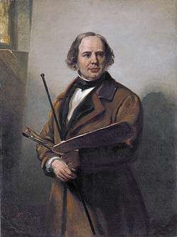
Jan Willem Pieneman, 1860

Nicolien Sauerbreij
- Jan van Almeloveen (1656 in Mijdrecht – 1684) a Dutch painter, engraver and draughtsman
- Theodorus Janssonius van Almeloveen (1657 in Mijdrecht – 1712) a Dutch physician and medical editor
- Jan Willem Pieneman (1779 in Abcoude – 1853) a painter
- Werenfried van Straaten (1913 in Mijdrecht – 2003) a Dutch Roman Catholic priest and social activist
- Hans van Vliet (born 1949 in Mijdrecht) a Dutch computer scientist and academic
- Michaël Dudok de Wit (born 1953 in Abcoude) a Dutch animator, director and illustrator [5]
- Saskia Rao-de Haas (born 1971 in Abcoude) a virtuoso cellist and composer
Sport
- Jan Grijseels (1890 in Abcoude-Proosdij – 1961) a Dutch track and field athlete, who competed in the 1912 Summer Olympics
- Gerard Maarse (1929 in Wilnis – 1989) a Dutch speed skater, competed in the 1952 & 1956 Winter Olympics
- Christine Aaftink (born 1966 in Abcoude) a retired speed skater, competed at the 1988, 1992 and 1994 Winter Olympics
- Tom Cordes (born 1966 in Wilnis) a retired Dutch cyclist, competed at the 1988 Summer Olympics
- Nicolien Sauerbreij (born 1979 in De Hoef) a Dutch professional snowboarder, competed in the 2002 & 2006 Winter Olympic Games and was a gold medal in the 2010 Winter Olympics
- Ivo Snijders (born 1980 in Mijdrecht) a rower, competed in the 2004 & 2008 Summer Olympics
Gallery
 Het Oude station van Vinkeveen
 Windmill Wilnis
 Netherlands, Ronde Venen, Kromme Mijdrecht
 Wilnis-Vinkeveen Platform 4, Jan Konings
References
- "Maarten Divendal" (in Dutch). Gemeente De Ronde Venen. Archived from the original on 5 April 2014. Retrieved 5 April 2014.
- "Kerncijfers wijken en buurten" [Key figures for neighbourhoods]. CBS Statline (in Dutch). CBS. 2 July 2013. Retrieved 12 March 2014.
- "Postcodetool for 3641AL". Actueel Hoogtebestand Nederland (in Dutch). Het Waterschapshuis. Retrieved 5 April 2014.
- "Bevolkingsontwikkeling; regio per maand" [Population growth; regions per month]. CBS Statline (in Dutch). CBS. 1 January 2019. Retrieved 1 January 2019.
- IMDb Database retrieved 20 September 2019
External links

- Official website
Places adjacent to De Ronde Venen | ||||||||||
|---|---|---|---|---|---|---|---|---|---|---|
| ||||||||||
Municipalities of Utrecht | ||
|---|---|---|
 | ||
| ||
| Authority control |
|
|---|
This article is issued from Wikipedia. The text is licensed under Creative Commons - Attribution - Sharealike. Additional terms may apply for the media files.