Nieuwegein
Nieuwegein [ˌniʋəˈɣɛi̯n] (![]()
Nieuwegein | |
|---|---|
.jpg) Canal through Nieuwegein | |
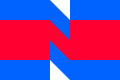 Flag  Coat of arms | |
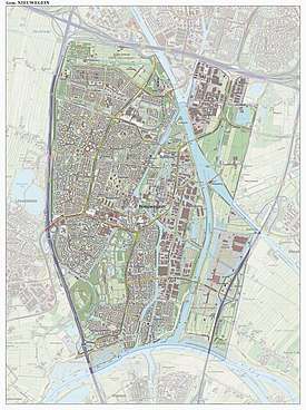
.svg.png) Location in Utrecht | |
| Coordinates: 52°2′N 5°5′E | |
| Country | Netherlands |
| Province | Utrecht |
| Established | 1 July 1971 |
| Government | |
| • Body | Municipal council |
| • Mayor | Frans Backhuijs (VVD) |
| Area | |
| • Total | 25.65 km2 (9.90 sq mi) |
| • Land | 23.66 km2 (9.14 sq mi) |
| • Water | 1.99 km2 (0.77 sq mi) |
| Elevation | 1 m (3 ft) |
| Population (January 2019)[4] | |
| • Total | 63,036 |
| • Density | 2,664/km2 (6,900/sq mi) |
| Demonym(s) | Nieuwegeiner |
| Time zone | UTC+1 (CET) |
| • Summer (DST) | UTC+2 (CEST) |
| Postcode | 3430–3439 |
| Area code | 030 |
| Website | www |
 | |
Several national sports federations are housed in Nieuwegein, including the NeVoBo (volleyball), KNZB (swimming), NBb (basketball) and KNCB (cricket).
There are three main secondary schools in the city, including the Anna van Rijn College, Oosterlicht College and the Cals College.
History
Nieuwegein was founded on 1 July 1971 as a planned city, following the merger of the former municipalities of Jutphaas and Vreeswijk. The new town was built for the expanding population of the city of Utrecht, and grew rapidly during the decades following its foundation.
In the area between Jutphaas and Vreeswijk there used to be a settlement called Geyne. This settlement received city rights in 1295 but was destroyed in 1333, in a war between the Bishop of Utrecht and the Count of Holland. Today only Oudegein House remains from that time. After the boards of Vreeswijk and Jutphaas had debated for some time about the name of the new place (including the alternative "'t Gein" as a reference to Geyne, fell) they decided to name the new place after this old settlement.[5]
Transportation
Nieuwegein is surrounded by three motorways (Dutch: autosnelweg), the A2 to the west, the A12 to the north and the A27 to the east.
Nieuwegein is connected to Utrecht and IJsselstein by the Sneltram (light rail) line. There is a pedestrian ferry across the river Lek to Vianen. Three canals flow through Nieuwegein: the Amsterdam-Rhine Canal, the Lek River and the Merwede Canal. There are also a few sports clubs in Nieuwegein, such as: KV Koveni, SV Geinoord, VSV Vreeswijk and JSV Nieuwegein.
Twin towns
Notable people
- Piet Schrijvers (born 1946 in Jutphaas) a Dutch football manager and former goalkeeper with 563 club caps
- Veronique Renard (born 1965) a Dutch author and visual artist
- Jasper van Dijk (born 1971 in Jutphaas) a Dutch politician
- Nine Kooiman (born 1980) a Dutch politician and former social worker
- Finne Jager (born 1984) stage name Phynn, a Dutch trance and techno DJ and producer
- Manuel "Grubby" Schenkhuizen (born 1986) a Dutch professional eSports player
- Sari van Veenendaal (born 1990) a Dutch football goalkeeper with Atlético Madrid Femenino, captains the Dutch national team
- Robin de Kruijf (born 1991) a Dutch volleyball player, competed at the 2016 Summer Olympics
Gallery
 Nieuwegein, hospital
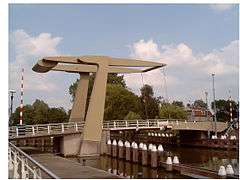 Nieuwegein, drawbridge
 Nieuwegein, windmill
 De Liesbosbrug in Nieuwegein
References
- "Burgemeester Frans Backhuijs" [Mayor Frans Backhuijs] (in Dutch). Gemeente Nieuwegein. Archived from the original on 8 April 2014. Retrieved 8 April 2014.
- "Kerncijfers wijken en buurten" [Key figures for neighbourhoods]. CBS Statline (in Dutch). CBS. 2 July 2013. Retrieved 12 March 2014.
- "Postcodetool for 3431LZ". Actueel Hoogtebestand Nederland (in Dutch). Het Waterschapshuis. Retrieved 8 April 2014.
- "Bevolkingsontwikkeling; regio per maand" [Population growth; regions per month]. CBS Statline (in Dutch). CBS. 1 January 2019. Retrieved 1 January 2019.
- "Nieuwegein", Wikipedia (in Dutch), 2019-05-26, retrieved 2019-06-14
External links

- Official website
Places adjacent to Nieuwegein | ||||||||||
|---|---|---|---|---|---|---|---|---|---|---|
| ||||||||||
Municipalities of Utrecht | ||
|---|---|---|
 | ||
| ||
| Authority control |
|
|---|