Mülheim
Mülheim an der Ruhr (German pronunciation: [ˈmyːlhaɪm ʔan deːɐ̯ ˈʁuːɐ̯] (![]()
Mülheim an der Ruhr | |
|---|---|
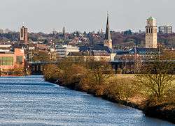 View of Mülheim's centre | |
 Flag Coat of arms | |
Location of Mülheim an der Ruhr within Urban districts of Germany district 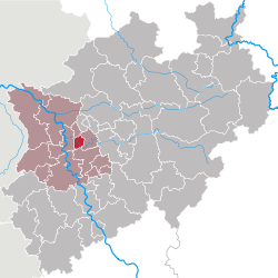 | |
 Mülheim an der Ruhr  Mülheim an der Ruhr | |
| Coordinates: 51°26′N 06°53′E | |
| Country | Germany |
| State | North Rhine-Westphalia |
| Admin. region | Düsseldorf |
| District | Urban districts of Germany |
| Subdivisions | 3 districts, 9 boroughs |
| Government | |
| • Lord Mayor | Ulrich Scholten (SPD) |
| Area | |
| • Total | 91.26 km2 (35.24 sq mi) |
| Highest elevation | 153 m (502 ft) |
| Lowest elevation | 26 m (85 ft) |
| Population (2018-12-31)[1] | |
| • Total | 170,880 |
| • Density | 1,900/km2 (4,800/sq mi) |
| Time zone | CET/CEST (UTC+1/+2) |
| Postal codes | 45468–45481 |
| Dialling codes | 0208 |
| Vehicle registration | MH |
| Website | www.muelheim-ruhr.de |
Mülheim received its town charter in 1808, and 100 years later the population exceeded 100,000, making Mülheim officially a city. At the time of the city's 200th anniversary with approximately 170,000 residents, it was counted among the smaller cities of Germany.
In 1966 Mülheim was the first city in the Ruhr Area to become completely free of coal mines, when its last coal mine "Rosenblumendelle" was closed. The former leather and coal city had successfully made a complete transformation to a diversified economic centre. With more than 50% covered by greenery and forest, the city is regarded as an attractive place to live between Düsseldorf and the rest of the Ruhr. It is the home of two Max Planck Institutes and, since 2009, the technical college Ruhr West. It has a station on the important railway between Dortmund and Duisburg and is served by Rhine-Ruhr S-Bahn lines S1 and S3.
Geography
Geographical location
Mülheim an der Ruhr lies at the junction of the hill country of the Lower Bergisches Land, the western Hellweg and the plane of the middle Lower Rhine region.
The Ruhr leaves the foothills of the Rhenish Massif and enters the Lower Rhine Plain at Mülheim. The Ruhr flows through the city from south-east to north-west for a distance of 14 km (9 miles) dividing it into two districts: Broich on its left (western) bank and Kirchenhügel (Church Hill) on its right (east) bank. The central city lies on both banks of the river, about 12 kilometres (7 miles) east of where the Ruhr discharges into the Rhine. Life in Mülheim is intermediate between the more urban, downstream, Düsseldorf and the more rural life of the upstream Ruhr.[2]
Largest groups of foreign residents by 31.12.2017:
| 4,885 | |
| 2,450 | |
| 1,665 | |
| 1,635 | |
| 1,285 | |
Geology
The northern foothills of the Rhenish Massif are characterised by the distinctive rock formation of the bare mountain slopes through which run coal-bearing layers which formed during the carboniferous period. Here the Ruhr cuts more than 50 meters deep into this Mittelgebirge. This natural erosion partly uncovered these mineable black coal deposits, which enabled their exploration and extraction using adits. However, the coal-rich layers became ever deeper as one progressed northward, which required setting up mines to extract the black coal. In contrast, the broad bayou (dead arm of a river) of Styrum borough is characteristic of the features of the Lower Rhine Plain.[3]
International relations
Mülheim is twinned with:[5]


Notable bands
- Bohren & der Club of Gore (founded 1992), a jazz & ambient band
Notable clubs
- 1. FC Mülheim (founded 1923), a football club
- VfB Speldorf (founded 1919), a football club
- HTC Uhlenhorst Mülheim (founded 1920), a field hockey club
Notable companies
- Plus (founded 1972), a supermarket chain
- Tengelmann (founded 1867), a holding company
- Aldi Süd Company (founded 1946 (split in two parts in 1960, renamed to Aldi Nord and Aldi Süd in 1962)), a discount supermarket chains
Notable people

- Wilhelm Rittenhausen (born 1644), founder of the first paper mill in North America.
- Gerhard Tersteegen (born 1697), a Reformed religious writer.
- Carl Arnold Kortum (born 1745), a physician, best known for his writing and poetry.
- August Bungert (born 1845), an opera composer and poet.
- Wilibald Nagel born 1863), a musicologist
- Hugo Stinnes (born 1870), an industrialist and founder of the German People's Party.
- Fritz Thyssen (born 1873), an industrialist associated with the Nazi Party of Adolf Hitler.
- Carl Otto von Eicken (born 1873), an otorhinolaryngologist.
- Heinrich Thyssen (born 1875), a German-Hungarian entrepreneur and art collector.
- Arthur Kaufmann (born 1888), an influential painter.
- Walter Hartmann (born 1891), a general of Artillery, serving during World War II.
- Otto Pankok (born 1893), a painter, printmaker, and sculptor.
- Otto Roelen (born 1897), a chemist.
- Karl Ziegler (born 1898), a chemist who won the Nobel Prize in Chemistry in 1963, with Giulio Natta, for work on polymers.
- Clärenore Stinnes (born 1901), a car racer; who was the first human to circumnavigate the world by automobile.
- Werner Best (born 1903), a jurist, police chief, and Nazi leader.
- Fritz Buchloh (born 1909), a football goalkeeper at two World Cups in 1934 and 1938, who played for VfB Speldorf.
- Günther Smend (born 1912), an officer and a resistance fighter involved in the July 20 Plot to assassinate Adolf Hitler.
- Johannes Bölter (1915-1987), a German Army tank commander during World War II.
- Karl Albrecht (born 1920), an entrepreneur who founded the discount supermarket chain Aldi with his brother Theo and among the richest men in the world.
- Theo Albrecht (1922-2010), an entrepreneur who was ranked as the 20th richest person in the world by Forbes magazine in 2007.
- Wilhelm Knabe (born 1923), an ecologist, pacifist, civil servant, politician and a co-founder of the Green Party in Germany.
- Wim Thoelke (born 1927), a TV entertainer.
- Hermann Bottenbruch (born 1928), mathematician and computer scientist
- Jürgen Sundermann (born 1940), a manager and former footballer.
- Hans Walitza (born 1945), a retired football striker and manager.
- Rudolf Seliger (born 1951), a former football striker, who played for MSV Duisburg.
- Bodo Hombach (born 1952), a politician and Member of the SPD.
- Monika Griefahn (born 1954), a politician of the SPD.
- Hans-Günter Bruns (born 1954), a retired footballer.
- Helge Schneider (born 1955), a comedian, jazz musician, author, film and theatre director, and actor.
- Ralph Morgenstern (born 1956), a television presenter and actor.
- Albrecht von Croÿ (born 1958), a journalist
- Ulla Kock am Brink (born 1961), a television presenter
- Hannelore Kraft (born 1961), a politician (SPD) and Minister-President of North Rhine-Westphalia.
- Ralf Lübke (born 1965), a retired athlete who specialized in the 200 metres.
- Carolin Emcke (born 1967), journalist.
- Willi Landgraf (born 1968), a soccer player, currently playing for the amateurs of Schalke 04.
- Sven Meinhardt (born 1971), a field hockey forward, who won the gold medal at the 1992 Summer Olympics.
- Kai Gehring (born 1977), a politician.
- André Lenz (born 1973), a football goalkeeper.
- Lars Burgsmüller (born 1975), a tennis player.
- Marion Rodewald (born 1976), a field hockey defender, who won the gold medal at the 2004 Summer Olympics.
- Felix Erdmann (born 1978), a rowing cox.
- Simone Hanselmann (born 1979), an actress.
- Salih Altın (born 1987), a football player.
Gallery

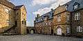 Courtyard of Schloss Broich
 Town Hall
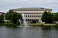 Mülheim Stadthalle
 View to the street and tram station Aktienstraße
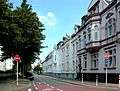 Friedrichstraße
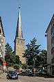 Petrikirche
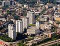 Highrise buildings in the city centre
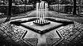 Water feature in MüGa-Park
See also
References
- "Bevölkerung der Gemeinden Nordrhein-Westfalens am 31. Dezember 2018" (in German). Landesbetrieb Information und Technik NRW. Retrieved 10 July 2019.
- "Mülheim an der Ruhr official website – The new Mülheim".


- "Mülheim an der Ruhr official website – Eine kurze Geschichte zur Geologie und zur Geographie des Stadtgebietes".
- "Mülheim an der Ruhr". Urban Rail. Retrieved 21 November 2015.
- "Städtepartnerschaften". muelheim-ruhr.de (in German). Mülheim an der Ruhr. Retrieved 2019-11-26.
External links
| Wikivoyage has a travel guide for Mülheim an der Ruhr. |
| Wikimedia Commons has media related to Mülheim an der Ruhr. |
- . Encyclopædia Britannica. 18 (11th ed.). 1911. p. 960.
- Official city homepage

| Authority control |
|
|---|