Possil railway station
Possil railway station was situated on Balmore Road, in the north of Glasgow, Scotland and served the Possilpark and Parkhouse areas of the city.
| Possil | |
|---|---|
 Possil Station in 2007 | |
| Location | |
| Place | Possilpark |
| Area | Glasgow |
| Coordinates | 55.89260°N 4.26201°W |
| Operations | |
| Original company | Lanarkshire and Dunbartonshire Railway |
| Pre-grouping | Caledonian Railway |
| Post-grouping | LMS |
| Platforms | 3 |
| History | |
| 1 February 1897[1] | Opened |
| 1 May 1908[1] | Closed |
| 8 January 1934[1] | Reopened |
| January 1954[1] | Renamed Possil North |
| 5 October 1964[1] | Closed |
| Disused railway stations in the United Kingdom | |
| Closed railway stations in Britain A B C D–F G H–J K–L M–O P–R S T–V W–Z | |
History
Part of the Lanarkshire and Dunbartonshire Railway, it served as the terminus for passenger services, but allowed for through services for the transport of freight. Services ran from Rutherglen to Possil, via Glasgow Central Railway.
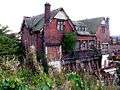
There was a goods yard at the site of the station, which was closed as part of the Beeching Axe. A scrapyard now occupies the site, although the station building and goods shed are still standing. The building has a slightly similar design to the now extinct Botanic Gardens structure on the Glasgow Central Railway. It has the company monogram "CR" carved in the stone above the two windows on the building's left frontal facade. It was in use as a bookmakers for many years in the 80s and 90s but by 2006, it was empty and falling into disrepair. It is now protected as a category C(S) listed building.[2]
| Preceding station | Historical railways | Following station | ||
|---|---|---|---|---|
| Maryhill Central Line and station closed |
Caledonian Railway Lanarkshire and Dunbartonshire Railway |
Terminus | ||
| Terminus | Caledonian Railway Hamiltonhill Branch |
Springburn Park Goods Line and station closed | ||
Gallery
 Looking east towards Possil Station in 2006
 Stonework detailing Caledonian Railway ownership
 Looking west towards Possil Station in 2007
See also
- Possilpark and Parkhouse railway station
References
Notes
Sources
- Butt, R. V. J. (1995). The Directory of Railway Stations: details every public and private passenger station, halt, platform and stopping place, past and present (1st ed.). Sparkford: Patrick Stephens Ltd. ISBN 978-1-85260-508-7. OCLC 60251199.
- Historic Environment Scotland. "479 Balmore Road, former Possil Station (Category C) (LB33744)". Retrieved 20 March 2019.
- Jowett, Alan (March 1989). Jowett's Railway Atlas of Great Britain and Ireland: From Pre-Grouping to the Present Day (1st ed.). Sparkford: Patrick Stephens Ltd. ISBN 978-1-85260-086-0. OCLC 22311137.