Langside railway station
Langside railway station is a railway station that serves the Langside and Newlands area of Glasgow, Scotland. It is located on the Cathcart Circle Line. Services are provided by Abellio ScotRail on behalf of Strathclyde Partnership for Transport.
| Langside | |
|---|---|
| Scottish Gaelic: An Leathad Fada[1] | |
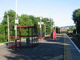 2005 view of station after removal of station building | |
| Location | |
| Place | Langside and Newlands |
| Local authority | Glasgow |
| Coordinates | 55.8208°N 4.2759°W |
| Grid reference | NS574609 |
| Operations | |
| Station code | LGS |
| Managed by | Abellio ScotRail |
| Number of platforms | 2 |
| Live arrivals/departures, station information and onward connections from National Rail Enquiries | |
| Annual rail passenger usage* | |
| 2014/15 | |
| 2015/16 | |
| 2016/17 | |
| 2017/18 | |
| 2018/19 | |
| Passenger Transport Executive | |
| PTE | SPT |
| Zone | G2 |
| History | |
| Original company | Cathcart District Railway |
| Pre-grouping | Caledonian Railway |
| Post-grouping | LMS |
| 2 April 1894 | Opened as Langside[2] |
| 5 November 1900 | Signal box closed[3] |
| 1 October 1901 | Renamed as Langside and Newlands[3] |
| 1905 | Signal box reopened during morning peak[3] |
| 23 August 1927 | Signal box closed and equipment removed[3] |
| 27 May 1962 | Renamed as Langside[3] |
| 13 August 1966 | Original station building burnt down[4] |
| National Rail – UK railway stations | |
| |
History

The station was opened as part of the western extension of the Cathcart District Railway on 2 April 1894. It consists of a single island platform accessed by a subway and stairs to Langside Drive at the west end, and Earls Park Avenue and Tanahill Road to the east, with a self-service ticket machine added in spring 2007. The Cathcart Circle Line has been electrified since 1962 by British Railways.
Services
1974 to 1979
Between the electrification of the WCML and the opening of the Argyle Line, trains ran Mondays to Saturdays, with two Cathcart Circle trains per hour in each direction and two Glasgow Central to Kirkhill trains per hour in each direction. Occasional peak hour trains were extended through to Motherwell via the Hamilton Circle lines.
1979 to early 1990s
Following the opening of the Argyle line, Kirkhill services were extended through to Newton.
Early 1990s to present day (2016)
The service pattern has been revised to include Sunday trains.
The service consists of one train between Glasgow Central and Newton in each direction every hour, seven days a week and one Cathcart Circle train in each direction on Mondays to Saturdays.
There is a higher frequency of trains in the weekday morning and evening rush hour periods.[5]
Routes
| Preceding station | Following station | |||
|---|---|---|---|---|
| Cathcart | Abellio ScotRail Cathcart Circle |
Pollokshaws East | ||
| King's Park | Abellio ScotRail Glasgow-Newton |
|||
| Historical railways | ||||
| Cathcart Line and station open |
Caledonian Railway Cathcart District Railway |
Pollokshaws East Line and station open | ||
References
Notes
- Brailsford 2017, Gaelic/English Station Index.
- Butt (1995), page 139
- Kernahan (1980)
- Kernahan (1980), page 64
- Table 223 National Rail timetable, May 2016
Sources
- Brailsford, Martyn, ed. (December 2017) [1987]. Railway Track Diagrams 1: Scotland & Isle of Man (6th ed.). Frome: Trackmaps. ISBN 978-0-9549866-9-8.CS1 maint: ref=harv (link)
- Butt, R. V. J. (1995). The Directory of Railway Stations: details every public and private passenger station, halt, platform and stopping place, past and present (1st ed.). Sparkford: Patrick Stephens Ltd. ISBN 978-1-85260-508-7. OCLC 60251199.
- Kernahan, Jack (1980). The Cathcart Circle. Falkirk, Stirlingshire: Scottish Railway Preservation Society. ISBN 0-9043-9601-0. OCLC 85045869.
- Jowett, Alan (March 1989). Jowett's Railway Atlas of Great Britain and Ireland: From Pre-Grouping to the Present Day (1st ed.). Sparkford: Patrick Stephens Ltd. ISBN 978-1-85260-086-0. OCLC 22311137.
- Jowett, Alan (2000). Jowett's Nationalised Railway Atlas (1st ed.). Penryn, Cornwall: Atlantic Transport Publishers. ISBN 978-0-906899-99-1. OCLC 228266687.