High Street (Glasgow) railway station
High Street railway station serves High Street in Glasgow, Scotland and the surrounding area. The station is managed by Abellio ScotRail and is served by trains on the North Clyde Line. It is located in the eastern part of the city centre, with Strathclyde University, Glasgow Cathedral and Glasgow Royal Infirmary being major institutions located nearby.
| High Street (Glasgow) | |
|---|---|
| Scottish Gaelic: Àrd-Shràid[1] | |
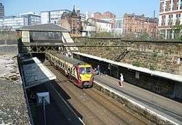 Train arriving at Glasgow High Street. The campus buildings of Strathclyde University are visible at the top of the photograph. | |
| Location | |
| Place | Glasgow |
| Local authority | Glasgow |
| Coordinates | 55.8594°N 4.2400°W |
| Grid reference | NS598651 |
| Operations | |
| Station code | HST |
| Managed by | Abellio ScotRail |
| Owned by | Network Rail |
| Number of platforms | 2 |
| Live arrivals/departures, station information and onward connections from National Rail Enquiries | |
| Annual rail passenger usage* | |
| 2014/15 | |
| 2015/16 | |
| 2016/17 | |
| 2017/18 | |
| 2018/19 | |
| Passenger Transport Executive | |
| PTE | SPT |
| History | |
| Original company | Glasgow City and District Railway |
| Pre-grouping | North British Railway |
| Post-grouping | London and North Eastern Railway |
| 15 March 1866 | Opened as College replacing the station on the CoGUR[2] |
| 1 January 1914 | Renamed as High Street[2][3] |
| National Rail – UK railway stations | |
| |
History
The first railway station in the area was College on the City of Glasgow Union Railway which closed with the opening of this station in 1866.[2] The station took its current name at the beginning of 1914.[3]
Plans
As part of the proposed Crossrail Glasgow initiative, High Street station may be demolished and relocated.[4]
Services
2008
There is a regular service Monday to Saturday to Glasgow Queen Street and beyond (Helensburgh Central etc.) on the North Clyde Line westbound and to Airdrie and Springburn eastbound.
Sundays there is a half-hourly service westbound to Glasgow Queen Street and Helensburgh Central and eastbound to Airdrie.
2013
The station has half-hourly services westbound to each of Helensburgh Central (limited stop), Balloch via Singer (stopping), Milngavie and Dalmuir via Yoker (stopping) (8tph in all via Queen Street, Partick and Hyndland). Eastbound there are 6tph to Airdrie, of which 4tph continue all the way to Edinburgh Waverley via Bathgate (two of these are limited stop, the others call at all intermediate stations). There is also a half-hourly service to Springburn although this has now been extended to Cumbernauld station and also now runs on a Sunday.[5]
On Sundays there is a half-hourly service to Helensburgh via Singer westbound and Edinburgh eastbound.
| Preceding station | Following station | |||
|---|---|---|---|---|
| Bellgrove | Abellio ScotRail North Clyde Line |
Glasgow Queen Street | ||
| Garrowhill | ||||
| Historical railways | ||||
| Gallowgate Central Line and Station closed |
Glasgow City and District Railway North British Railway |
Glasgow Queen Street Line and Station open | ||
| Bellgrove Line and Station open |
Coatbridge Branch North British Railway |
Junction between Coatbridge Branch and Glasgow City and District Railway | ||
References
Notes
- Brailsford 2017, Gaelic/English Station Index.
- Butt (1995), page 66
- Butt (1995), page 120
- "What will Crossrail Glasgow involve?". Archived from the original on 17 January 2008. Retrieved 10 February 2008.
- GB National Rail Timetable 2013-14, Table 226
Sources
- Brailsford, Martyn, ed. (December 2017) [1987]. Railway Track Diagrams 1: Scotland & Isle of Man (6th ed.). Frome: Trackmaps. ISBN 978-0-9549866-9-8.CS1 maint: ref=harv (link)
- Butt, R. V. J. (1995). The Directory of Railway Stations: details every public and private passenger station, halt, platform and stopping place, past and present (1st ed.). Sparkford: Patrick Stephens Ltd. ISBN 978-1-85260-508-7. OCLC 60251199.
- Jowett, Alan (March 1989). Jowett's Railway Atlas of Great Britain and Ireland: From Pre-Grouping to the Present Day (1st ed.). Sparkford: Patrick Stephens Ltd. ISBN 978-1-85260-086-0. OCLC 22311137.