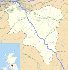
Rutherglen
Rutherglen (/ˌrʌðərˈɡlɛn/, Scots: Ruglen) is a town in South Lanarkshire, Scotland, located immediately south-east of Glasgow – 3 miles (4.8 km) from its city centre – and directly south of the River Clyde. Having existed as a Lanarkshire burgh in its own right for more than 800 years, in 1975 Rutherglen lost its own local council and administratively became a component of the City of Glasgow District Council within the Strathclyde region (along with neighbouring Cambuslang).[2] In 1996 the towns were reallocated to the South Lanarkshire council area.[3][4][5]
Rutherglen
| |
|---|---|
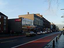
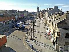 Main Street, the main shopping area of Rutherglen | |
| Population | 31,190 |
| OS grid reference | NS614616 |
| Lieutenancy area | |
| Country | Scotland |
| Sovereign state | United Kingdom |
| Post town | GLASGOW[1] |
| Postcode district | G73 |
| Dialling code | 0141 |
| Police | Scotland |
| Fire | Scottish |
| Ambulance | Scottish |
| UK Parliament | |
| Scottish Parliament | |
History
Rutherglen received the status of Royal Burgh in 1126 by Royal Charter from King David I of Scotland[6] who ruled from 1124 to 1153. It gradually diminished in importance as neighbouring Glasgow grew in power and size.[7]
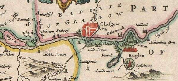
In the 14th century Walter Stewart, father of King Robert II, was granted Farme Castle. This was located close to Farme Cross in the north of Rutherglen, and stood until the 1960s.[8]
Rutherglen was a centre of heavy industry,[9][6][10] having a long coal mining tradition which died out by 1950.[11][12] J&J White's Chemical Works (later ACC Chrome & Chemicals) in Shawfield, which was in existence from 1820 to 1967, produced more than 70 per cent of the UK's chromate products including chromic acid, chromic oxide pigment, sodium and potassium chromate and dichromate. Today there is a significant legacy of soluble chromium (VI) waste in the area.[11][13]
Horse and cattle markets, including the regular Beltane Fair in May and St Luke's Fair in November (accompanied by the baking of sour cakes by locals)[14] were also common and popular until the 20th century.[11][15][16][17]
Rutherglen is nowadays primarily a dormitory suburb of Glasgow.[18]
Etymology
The name of Rutherglen, as well as its Scots name Ruglen,[19] is perhaps from Scottish Gaelic An Ruadh-Ghleann, meaning 'the red valley'.[11][20] The derivation may also however be Welsh, or Cumbric and mean "the valley of Rydderch". Rydderch – pronounced 'rutherch' – 'ruther' as in 'brother' and 'ch' as in 'loch' – was one of the most famous kings associated with the Welsh-speaking kingdom which centred on Dumbarton.[21][6][7]
Governance
Westminster
A separate constituency in the Parliament of Scotland from the late 16th century,[7] Rutherglen was a parliamentary burgh represented in the UK Parliament as a component of Glasgow Burghs constituency from 1708 to 1832,[7] and as a component of Kilmarnock Burghs from 1832 to 1918. In 1918, the Rutherglen constituency was created, which became Glasgow Rutherglen in 1983. In 2005, Scottish constituencies for the UK parliament were reviewed with many new seats introduced, and the town is now within the Rutherglen and Hamilton West constituency.
Following the 2019 election, Margaret Ferrier of the Scottish National Party is the local MP,[22] replacing Gerard Killen of Scottish Labour who in 2017 had narrowly defeated incumbent Ferrier,[23][24] herself originally elected in 2015.[25][26]
Holyrood
In 1999, the Scottish Parliamentary constituency of Glasgow Rutherglen was created, with the same boundaries as the then UK parliamentary constituency. In 2011, The constituency was redrawn and renamed simply Rutherglen (although it also encompasses Cambuslang and Blantyre). Following the 2016 elections, Clare Haughey (SNP) is the MSP for Rutherglen. The defeated incumbent James Kelly (Labour) was elected as a list MSP[27] for the Glasgow region which includes Rutherglen due to the town's proximity to the city.[28] All local representatives have strong personal ties to the area.
South Lanarkshire Council
Administratively, the historic town centre is within the Rutherglen Central and North ward of South Lanarkshire Council,[29][30] which has a population of around 15,000.[31] Taking another ward encompassing the southern parts of the town into consideration,[32] its overall population was approximately 30,000 in 2016. With neighbouring Cambuslang's figures being very similar,[33][34] the many services and amenities shared between the towns should provide for 60,000 residents, many assessed as living in economic hardship.[35]
Transport
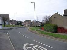
Rutherglen Burgh is served by Rutherglen railway station (opened in 1849), with Croftfoot and Burnside stations closer to southern parts of the town. There are also numerous bus links into Glasgow city centre or other destinations such as Hamilton, East Kilbride, Govanhill and Dennistoun, all services either running directly along the Main Street (which has dedicated public transport lanes for peak times), or close to it via Mill Street / Glasgow Road (A730) to the west or Stonelaw Road / Farmeloan Road (A749) to the east.[36][37] Glasgow Corporation Tramways operated routes in the area from the early 1900s until the late 1950s.
Completion of the M74 Extension in 2011 meant that there is a six-motorway bisecting the northern part of the town, allowing easier access to places such as Glasgow Airport and the English border. Some years after the project was completed, studies show that pollution levels on Rutherglen's densely populated Main Street were still measured consistently at dangerously high levels, despite forecasts that traffic levels on urban streets in areas served by the motorway would reduce.[38][39][40]
Media
The local newspaper is the Rutherglen Reformer. The local community radio station is CamGlen Radio.
Geography
The Royal Burgh of Rutherglen has expanded over the years and now encompasses many other neighbourhoods, the majority built after World War II on land which was either farms or rural estates.[41][42]
Since being granted Royal Burgh status by King David I in the 12th century, the town has grown considerably from its origins as little more than a single street,[41][43] and although growth has been hampered to some extent by the proximity of the river to the north and the encroaching Glasgow urban sprawl to the west, it now covers a much larger area than the initial Burgh boundaries,[10][44][45] although the aforementioned restrictions mean its administrative centre with the majority of facilities and the highest population density is concentrated at the north of its overall territory rather than towards the geographic centre (neighbouring Cambuslang has a similar issue: its town centre is in the far west of its territory, with its boundaries with Rutherglen and the river preventing any expansion in those directions).
Historic areas such as Farme Cross, Bankhead and Gallowflat have changed greatly over the years[45][10][44] and the village of Burnside (which falls under the Rutherglen boundary but has its own Community Council) also expanded to share a single suburban settlement with its larger neighbour. More recent post-war developments at Newfield and Burnhill within the older part of town, plus those on the peripheries including Blairbeth, Cathkin, Eastfield, Fernhill, Spittal and Springhall[44] have given the town a frequently-changing character. Other than some shopping areas and the large industrial estates in Farme Cross and Shawfield, the neighbourhoods referred to are residential in type; the 1922 book Rutherglen Lore indicates a deliberate intention for the historic Burgh area to be encircled to the south by residential suburbs, while all land to its north would be dedicated to industry, and that remains the case a century later.
Burgh (Main Street) and Clincarthill
The Burgh area includes the old heart of the Royal Burgh of Rutherglen around the ancient and unusually wide, tree-lined Main Street and its environs,[41][45][7] which have been designated a conservation area since 2008.[43] It features several religious establishments, various pubs, shops and restaurants, historic and modern civic buildings and community facilities, all within a dense network of housing, mainly tenements.[11][43] In the 2000s, a webcam focused on the everyday activities at the western end of Main Street was recognised as having among the highest number of views in the world at the time for footage of its type, despite there being no obvious reason for this popularity;[46] the webcam is no longer in operation, although later proposals were made by local civic figures to have another installed.[47]
.jpg)
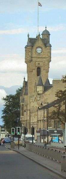
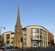
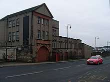
The dominant architectural feature of the Main Street, on its north side, is the imposing Town Hall built in 1862 to a design by Charles Wilson.[43][48] Having fallen into disrepair and disuse[48][43] the Category A-listed building was refurbished and extended around 2005[49][50][51] and today is a venue for weddings, theatrical performances and exhibitions,[11][52] while still providing some local services.[53]
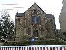
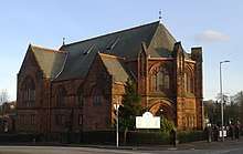
Most of the other most important Rutherglen landmarks are in the immediate vicinity of the Town Hall. To its west is Rutherglen Old Parish Church,[11][43] the fourth incarnation of the institution (which has had a building on the site since around 600 AD)[54] constructed in 1902 to a J. J. Burnet design.[55] Between the church and the town hall sits the ancient graveyard (13th century), the St Mary's bell tower (16th century) and its Kirk Port stone entrance (17th century).[11][43][56][57][45] On the corner of Main Street and Queen Street outside the church is a statue of Dr. James Gorman (1832–1899), a well-known local surgeon – this was erected in 1901 by public subscription due to his great standing in the area for his actions, including treating the injured after mining disasters.[43][11][56][58] To the rear of the church is a Masonic Hall dating from 1897 and built to replace older premises on Cathcart Road – the group can trace their origins locally back to the 1760s.[59][60]
.jpg) Rutherglen Old Parish Church (1902)
Rutherglen Old Parish Church (1902)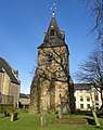 St Mary's bell tower in churchyard (16th century)
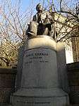 Dr Gorman's statue
.jpg) Royal Arch Lodge 116
Royal Arch Lodge 116
To the immediate east of the Town Hall is the burgh's public library[43][61] constructed in 1907 to an Edwardian design by Sinclair & Ballantine[62] (technically 'Post Office and Library', but the dedicated post office closed in 2005,[63] with its replacement inside an existing shop further east along the Main Street).[64] A Carnegie library, its main hall to the rear features a stained-glass dome in the roof and oak panelling in the interior.[65] Its first librarian, who also lived in the upper floor, was William Ross Shearer, author of the 1922 book Rutherglen Lore which would come to be considered one of the most important references for the town's long history.[66][67] The building was refurbished in the early 1990s and re-opened once again in 2010 following a further extensive refurbishment which included an expansion into the Post Office section.[63][68] On the wide pavement outside the library is a replica of the town's mercat cross (the original stood nearby from the 12th to the 18th century),[43] erected in 1926 as part of Rutherglen's octo-centenary celebrations, and in memory of a former provost of the burgh. It was earlier the site of the old 'Tollbooth and Gaol' (town hall and prison) which was constructed in the 1760s and demolished in the 1900s.[43][69][45] Behind the library on King Street is the premises of the local branch of The Salvation Army whose brass band play regularly at the Old Parish Church and who have had a presence in the town since the 1880s;[70] their hall stands roughly on the site of the mediaeval Rutherglen Castle,[71] and replaced a wooden building initially used by the Rechabite Society.[72] The local fire brigade (established 1892) was also based nearby, but since 1970 the local station has been at Cambuslang[73][11] with other stations fairly close at Polmadie and Castlemilk.
 St Columbkille's Church
.jpg) Rutherglen's only surviving cinema building, the Vogue
Rutherglen's only surviving cinema building, the Vogue.jpg) Rutherglen Library and Post Office building (1907)
Rutherglen Library and Post Office building (1907)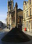 Mercat Cross replica outside library
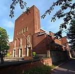
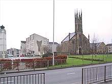
Directly across from the Town Hall is St Columbkille's RC Church,[11][74] the current main building of which dates from 1940 (designed by Gillespie, Kidd & Coia),[43] although the congregation was established in 1851 and there has been a documented Catholic presence in the local area since the 6th century.[75] Behind the church are its older halls,[10] previously serving as a school,[76] which was rebuilt internally after a major fire in 2004.[77] To the west of the church, hemmed in by tenements is the 1930s Vogue Cinema, which is the only surviving building of its type in the town, although it was converted to a bingo hall in the 1970s.[78][79][80]
Other buildings of note include the 128 feet (39 m) spire of Rutherglen East Parish Church at Rutherglen Cross – the junction of Main Street, Farmeloan Road and Stonelaw Road – which was originally built in 1872 for a Reformed Presbyterian congregation,[81][82][10] closed in 1981 and was converted into the 'Aspire Business Centre' in 2003.[83] Its church halls became a facility used by local community organisations.[84][85] After a new eastern section of Main Street was set out with the removal of old cottages beside the church (this would later be extended through the Gallowflat area), in 1914 a cinema, 'The Pavilion' was constructed there to a design by John Fairweather; later being refurbished in 1930 as 'Green’s Picturedrome', it closed in 1959 although was not demolished until the 1980s.[78][79][80] A further small church (Rutherglen Congregational Church) was also built opposite the cinema; in the wake of the congregation moving on to new premises on Johnstone Drive (where they remain to this day),[86][87][44] its halls were occupied from the late 1930s by the Rutherglen Repertory Theatre, established by Glaswegian actress Molly Urquhart who set up in the town for no particular reason apart from the venue being available. The halls are now apartments (having been the 'Clyde Club' until a 1990s fire) and the theatre company have their premises a few blocks south on Hamilton Road, with many of their performances held at the renovated Town Hall.[88]
_2016-02-28.jpg)
.jpg)
Behind the East Church on King Street, once the location of one of the local Stonelaw coal mines in the 19th century,[45][11] is the Rutherglen police station which was built in the mid-1950s; prior to this the local force, established as the Rutherglen Special Constabulary in 1848 (later part of Lanarkshire Constabulary, thereafter Strathclyde Police and today Police Scotland), had their premises and cells in the Tollbooth followed by the new Town Hall.[56] The police station is adjacent to the former district Court and museum[89][44] and is overlooked to the south by 'Royal Burgh House', an office block built in 1998, originally occupied by the local authority which subsequently relocated the services to East Kilbride and Cambuslang.[90][91]
Further west between King Street and High Street, the ornate Rutherglen Evangelistic Institute was completed in 1887[92] with input from local businessmen John White (Lord Overtoun)[93] and Daniel Rodger[94] (brother of the local MP Adam Keir Rodger) and played a significant role in supporting local members in military service during World War I,[95][96] but had fallen out of use and been demolished by the 1940s, with only the later housekeeper's residence still remaining and modern apartments occupying the rest of the site;[11][97] however, the adjacent three-storey Burgh Primary School building (1901)[11][98] has been retained and was converted to a business centre.[99][100] Across the street to the north is Glenburgh Nursery Centre, a modern dedicated council childcare facility for the town centre.[101]
In 2010, Burgh Primary moved from their 1901 building to new premises a few blocks east, still in the heart of town on Victoria Street,[11][102] – this site was previously the location of the Macdonald School: built 1865, used in its later years as an annex for Rutherglen Academy,[103] then as a nursery and community centre, demolished in the 2000s.[63] The new school's mini sports pitch was once the site of the Rutherglen United Presbyterian Church from 1836 until the 1910s[43][104][105] while on the opposite side of King Street sits the current Free Presbyterian Church of Ulster premises, next to a wynd leading to Main Street which has existed for several centuries.
The Mitchell Arcade indoor shopping precinct on the south side of Main Street, built in the early 1970s[43] in place of a block of older tenements on Mitchell Street and Stonelaw Road[56] and a small cinema (the 'Grand Central')[78][79][80][44] was given a makeover in 2014 and renamed the Rutherglen Exchange Shopping Centre;[106][107] it has a rooftop car park and used to feature a daily market. A branch of Boots Chemist occupied a corner site both in the older buildings at Rutherglen Cross and when these were replaced, having a presence at the same location in the town for over a century. The land to the east on Stonelaw Road stood unused for several years until the local council housing office (later a business centre) was constructed there in the 1990s,[108] while as of 2020 the land across the road once occupied by the 'Electric Palace Cinema' (later a billiards hall) has never been built upon.[78][79][80]
A short distance to the west of the Arcade, the contemporary Greenhill Court housing complex[109][110][111] similarly replaced a street of tenements at Regent Street,[56] as well as the Royal Burgh Bakery,[112][113][10][44] home to Paterson's bakers (biscuits and oatcakes) from 1895 until 1971 when the factory became outdated and production moved to Livingston.[112]
At what is now the western end of Main Street (since it was shortened by the construction of the dual carriageway bypass first phase in the early 1970s), there are two public houses on its northern side; the 'Vogue Bar' has been present for some decades and is known as a base for local Celtic F.C. supporters;[114] the 'Picture House' is a 2009 expansion of the equally venerable Linn O Dee establishment,[115] taking inspiration for its name from another disappeared cinema, the 'Rio', which was demolished in 1971 to make way for the bypass.[78][79][80] This extensive work on the road network in this part of the town also caused the destruction of the town's medical clinic (services were relocated to a new Health Centre on Stonelaw Road) and many other older residential and commercial buildings, and physically removed the war memorial and a church from the heart of the burgh (see Burnhill). Most of the pubs in Rutherglen are on the north side of the Main Street and to its west, a legacy of the Temperance (Scotland) Act 1913 when the south side of the street and other parts were declared 'dry areas' following local referendums on the issue. The Act was repealed in the 1970s, but it still drew comment in local media in 2012[116] when a textiles shop (previously the local co-operative society's headquarters) on the south side of Main Street opposite the Vogue and Picture House was to be converted into a new Wetherspoons pub ('An Ruadh-Ghleann', taking its name from the Gaelic version of Rutherglen).[20]
.jpg)
There is a high concentration of licensed premises in the vicinity, several with a continuous presence on the same spot since the mid-19th century[10][44] and others which have been forced to relocate but carry the traditions of earlier versions[117][118][119] including the three aforementioned hostelries on Main Street plus 'The Sportsman' on Glasgow Road, 'The Millcroft' and 'Wallace Bar' on the old section of Mill Street and the 'Cathkin Inn' two blocks further south, 'Harleys Sky Bar', 'Gormans' and 'The Burgh Bar' around Queen Street, 'The Stirrup Cup' opposite the shopping arcade, 'Chapmans' at Rutherglen Cross and the 'Victoria Bar' a short distance further north, plus three dedicated off-sales and additional licensed grocers, and several other premises which were converted from bars to other uses in the early-21st century. As well as the clustering of pubs being explained by historic licensing arrangements, the proximity of Hampden Park and Celtic Park football stadiums also brings some occasional additional custom to the area, which to some extent also accounts for a high number of bookmakers around the Main Street.
While redevelopment saw many of central Rutherglen's older tenements swept away,[44] many of the others also fell into disrepair until work to maintain them was carried out by Rutherglen Housing Action Group, established in 1979.[120][121] This later became the Rutherglen and Cambuslang Housing Association, based at the Aspire Centre and managing hundreds of properties in the area,[122][123] although some like Greenhill Court are still managed directly by the local authority.[124] Despite new projects being undertaken regularly by the organisation in the limited space available in the area, the shortage of homes available for rent became a major issue locally going into the 21st century.[125]
.jpg)
The town's current railway station opened in 1979[126] is the fourth such provision in the immediate area, with the first (1842-1879)[127] and second (1879-1897)[128][10] - on what are now the West Coast Main Line tracks which no longer offer a stop in Rutherglen - accessed from either side of Farmeloan Road. The third version (1892-1979)[129][10][44] was further west and accessed off Queen Street; it was soon extended in 1896 to include the Glasgow Central Railway line (which is now the Argyle Line served by the current station) which increased the total number of platforms on various lines to twelve,[130][44] but this gradually reduced until 1964 when the Beeching cuts resulted in the Glasgow Central extension closing, with only two at Queen Street remaining. On the opening of the Argyle Line and new station in 1979 the old station was abandoned, although its crumbling platforms are still visible and its entrance stairway and walkway is linked to its replacement.
Located on an island platform and now directly under elevated M74 motorway, the current station is connected to the Burgh streets via a covered pedestrian overbridge, the main entrance to which on Victoria Street was decorated with murals themed on the history of the town in 2018.[131] Beside this mural to the west is Reuther Hall, a community centre used by a retired ladies group among others,[132] while to the east is the building previously used as the town Employment Exchange - it has been converted into business use, as has the Youth Employment Exchange on King Street, while the local JobCentre service is now based further south at Greenhill Road.
Clincarthill
Lying immediately to the south of the Burgh area between Greenhill Road and Johnstone Drive, Clincarthill rises high over the Main Street offering fine northern views. The area has a distinctive character of its own, with plenty of remaining old sandstone tenements, villas and terraced houses from the late 19th and early 20th century,[10][44] some on the incline accessible only via footpaths. A pedestrian overbridge across the busy Mill Street dual carriageway links Clincarthill with the Bankhead neighbourhood to its west. There are several places of worship in the area: Minhaj-ul-Quran mosque (previously a Scout hall), Rutherglen Baptist Church (established 1889, built 1903) and Rutherglen United Free Church (established 1902, built 1935),[86][87] while the town's JobCentre is built on the site of another (Greenhill Church). Adjacent to this is a vacant plot which was the location of Rutherglen Swimming Pool from 1967 until the 2005 but has lain empty since.[133]
There is also a Catholic primary school (St Columbkille's) in Clincarthill,[134] built on the site of Bellevue House, a children's home run by the Daughters of Charity of Saint Vincent de Paul from 1912 to 1961 which was discredited in the 2018 Scottish Child Abuse Inquiry.[135][136]
Rutherglen Primary Care Centre, the town's public health facility,[137] is located on flatter land south of Clincarthill backing on to Overtoun Park (where another hill forms to the west) and built around 1999 to replace the Rutherglen Health Centre,[138] which it itself had replaced the old clinic on Main Street that was bulldozed to allow construction of the Mill Street bypass road. Rutherglen Maternity Hospital stood adjacent from the mid 1970s to the late 1990s),[139][138] but despite a good record of patient care and only 20 years in operation, it was closed and demolished to alleviate financial burdens in the local health board and concentrate a wider range of services over fewer sites.[140][141] With the hospital constructed on reclaimed park land that had been an excavated part of a mine before being filled in,[44] there was also concern that chromium contamination was present in the ground.[138] The immediate area also features a number of old buildings, including a square block of red sandstone tenements[56] and some grand villas.
Farme Cross
Farme Cross is one of the boundary areas of Rutherglen and is surrounded to the north by the River Clyde with Glasgow's Dalmarnock district on the opposite bank, the two sides being linked by iron road and rail bridges dating from the 1890s,[142][143] while it is separated from the old Burgh area uphill to the south by 19th century railway tracks and a 21st century motorway. It originated as the Farme estate crown property which was passed through noble families for centuries. Centred around the Farme Castle,[41][8][144] it became known for coal mining from the early 19th century[7][12][145][146][147] under the control of estate owner James Farie, with other industries soon following. The roads through the territory (A724 and A749) meet to join two busy routes between eastern Glasgow to the north, Rutherglen to the south and Cambuslang (via Eastfield) to the east. It was served by Glasgow's tram network providing transport for the workforces, a role still performed by buses.[148]
There are several historic buildings and pieces of street art here,[149] including a set of four carved standing stones ('Boundary Stones' by Richard Brown, 2001) installed in an area of open ground to commemorate the history of the Royal Burgh and its original boundary stones,[150] some of which (dating back to the 18th and 19th century) are themselves still in situ, mostly at Farme Cross and in the southern parts of the town.[11] Another monument ('Slipsteam' by Joseph Ingleby, 2001)[151] alongside the river near Dalmarnock Bridge involves metallic cogged mouldings (featuring designs by local schoolchildren) placed on brick walls and emerging in loops from the ground, and recalls local industry on the Clyde and the contours of the river itself.[152]
Businesses at Farme Cross were once many and varied,[10][44] with the energy to operate them supplied by a large power station just over the river,[153][154][155][156] where the nearby Dalmarnock, Bridgeton and Parkhead districts also developed a similar strong industrial profile.[157][158] The industries included:[149]
- the Farme Castle Colliery with two pits, associated row cottages and branch railway[147][145][146]
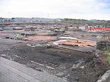
- the Caledonian Pottery[159] which was latterly operated by Hartley's Jams[160] and was later the site of a small steel works; lying in the path of the new motorway construction, it was first subject to an excavation which uncovered the foundations of the original buildings for examination[161][162]
- Scotia Bolt Works[163]
- three dyeing works (Clyde Bank Works; David Millar & Co / Clydesdale Dye Works; Eastfield Dye Works which later became the Eastfield Chair Works)[164][165]
- three tube/pipe works (Unicode; James Menzies and Co / Phoenix Tubeworks; and the adjacent James Eadie and Sons / Clydesdale Tube Works, both acquired by Stewarts & Lloyds)[166][167][168]
- three wire rope works (John Todd & Son / Rutherglen Ropes; John Wilson & Son / Eastfield Ropery; and Clyde Patent Rope Works / Allan, Whyte and Co, acquired by British Ropes)[169][170] the latter of which had a distinctive sandstone office with turret situated on the cross, demolished in the 1990s after falling into disrepair[149][171]
- two paper mills (Eastfield Paper Mill near the river and the 'Old Farme' steading which has survived to the 21st century, and the larger Clyde Paper Mill off Cambuslang Road),[172][173][174]
- Adam's Brickworks[175]
- the Monogram bedding factory[176] (previously used by the EKCO radio equipment company)[177]
By the 1970s, the vast majority of these industries had either severely contracted or in most cases closed altogether,[149] causing severe employment difficulties for the area.[178] The low-lying area was severely impacted by a flood in 1994,[176] as had occurred previously in 1903,[179] resulting in improved prevention measures being introduced.[180] One of the firms which endured into the 21st century, Sanmex Chemicals,[181] eventually left town in the 2010s after a merger with an Ayrshire-based rival.[182] Another, the bottling and distribution arm of The Speyside distillery, had closed a few years earlier.[183] Both sites were soon advertised as new investment opportunities.[184][185]
A Tesco superstore built in the early 21st century on some of the vacant former industrial land between the river and railway lines off Dalmarnock Road (specifically the Phoenix Tubeworks, which had been converted into a trading estate) was later extended to feature two fast-food restaurants.[186] A small light industry development borders the superstore,[187] and this mirrors the changes throughout Farme Cross, with the bustling but dirty factories of the past gradually being replaced by small workshops, business units and modern warehouses and depots, though in some cases with an intervening period of several years as derelict buildings, then cleared brownfield land awaiting development. Regeneration projects (controlled by the Clyde Gateway organisation)[188] accelerated following the completion of the M74 Extension to the Glasgow Region Motorway network in 2011, with Junction 2 directly serving Farme Cross. This led to more ambitious plans being adopted for the area (as well as at Shawfield),[189][190] including the Rutherglen Links environmentally-friendly business park,[148][191][192] the main building for which occupies a prominent location off Farmeloan Road,[176][193][194] with further office pavilions further east towards the motorway junction.[195]
.jpg)
_2016-02-28.jpg)
Various further commercial proposals have been put forward for the eastern part of this area,[196][197][198] with disused depots levelled and a driving range in the early stages of construction in 2020.[199]
Despite its identity being dominated by heavy industry, there has always been a residential aspect to Farme Cross.[44] The oldest surviving examples are the Terrace cottages,[149][200][201] a cluster of four small streets built for local workers by the Glasgow Working Men's Investment and Building Society in the 1880s, the only co-operative housing of this kind in the town and built at angles off the main road, designated as a conservation area in the 1980s.[149] Unusually, the two-storey buildings feature main doors at the front and the back to access flats on different levels - a similar design can be seen in the Colony houses at several locations in Edinburgh.[202][203] Traditional tenements which once stood right on the cross in front of the terraces[204] and opposite on Farmeloan Road were demolished in the mid-20th century,[149] but some slightly newer sandstone tenements remain on the north side of Cambuslang Road and Dalmarnock Road, including a Category C-listed corner block[171] which houses the area's sole public house at ground level (known as 'Tennents' for decades, with a small number of resident clientele, the business suffered as the passing trade from factory workers dwindled, changing hands several times in the early 21st century).[205][206] The area facing this block, where British Ropes once had their turreted offices, was developed as the Lloyd Court apartment complex in the 2000s, the design of which resembles older styles. A small inter-war development of cottage flats around Montraive Street and grey concrete tenements at Barnflat Street and Baronald Street received new neighbours in the early 2000s with the building of around 100 houses at Farme Castle Court (this is actually slightly east of the actual location of Farme Castle).
Rutherglen's Kingdom Hall (established in 1958, rebuilt in 2012) is located in Farme Cross on Baronald Street.[207] Across the street is a playground and a small local community hall. The Farme Bowling Club on Cambuslang Road, which was linked to the nearby Clyde Paper Mill, closed its doors in 2006.[208]
The Cuningar Loop is an area of land south of the River Clyde near Farme Cross. An isolated meander of the river which was once a Glasgow sewage treatment facility,[10] then infilled with rubble from the city's slum clearance programme before being abandoned to become overgrown, it has now been transformed into a woodland park[209] connecting across the Clyde to the City of Glasgow (Dalmarnock) and the Commonwealth Games village development via a new footbridge.
Shawfield
The Shawfield district, the mostly northerly in the town and once a country estate[210] before being converted into a chemicals facility by the White family, is still industrial in nature, but much of it abandoned in the early 21st century due to the collapse of heavy industry generally, and contamination from the Whites Chemical Works in particular.[211][212][213][214][215] The Clyde Gateway projects aim to reinvest in this area and create new business parks and make the River Clyde accessible in Rutherglen again[216][217][218] – the town's old port, once home of Thomas Seath shipbuilders which specialised in Clutha ferries and paddle steamers, is located here.[56][219][220] Currently Shawfield Stadium (the former home of Clyde F.C.) hosts greyhound racing; although not immediately noticeable, the building has Art Deco features.
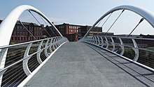
Rutherglen Bridge at Shawfield is the oldest crossing between Rutherglen and Glasgow – specifically the Bridgeton district of the city which was named after the bridge when its construction accelerated industrial growth and trade in the previously agricultural area.[10] Far more recently, a 'smartbridge' for pedestrian and cyclists was built to encourage links between the regenerating Shawfield area and Dalmarnock railway station, also in connection with the 2014 Commonwealth Games, several of the events for which were held nearby at the Emirates Arena.[221][222]
Wardlawhill, Gallowflat and Stonelaw
Wardlawhill
Lying across Stonelaw Road east of Clincarthill, the Wardlawhill area includes some older large houses and tenement buildings;[56] a BBC Scotland report found that Wardlaw Drive, the hill's northern incline lined with tenements, ranked seventh among the steepest streets in Scotland.[223] Adjacent to this street, placed at the top of stairs at Hamilton Road and partly built into the hill itself, is the Sri Sundara Ganapathy Hindu Temple (built 1882), previously Wardlawhill Parish Church – whose congregation merged with the West Parish at Burnhill in 2007,[224][225] the building being sold in 2010.[226] The church halls across the road are still used by local youth groups such as the Boys Brigade.[224][227]
To the south, on the other side of the hill is the Rutherglen Academy building on Melrose Avenue (built 1886)[10] which later became Stonelaw High School and was converted into apartments in 2001.[228][229][11][230][231] Opposite the Academy is a small early 20th century apexed building, originally St Stephen's Episcopal Church, nowadays used as a Masonic Lodge since 1971, after the group's previous premises on Cathcart Street[10] (dating from 1875, latterly also used by the neighbouring Toryglen chapter) were demolished for the Mill Street bypass project.[232][233] The house system of Stonelaw High School used to be named from avenues in the area (Jedburgh, Dryburgh, Melrose and Kelso, taken from the Scottish Borders); however, at the start of the 2018 school year this theme changed to Scottish Islands: Arran, Bute and Skye.
Gallowflat
.jpg)
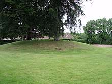
The Gallowflat area, known locally as East Main Street, features some 1920s cottage flats [234] and tenement buildings, dating from the construction of an extension to the Main Street – although it may appear natural for the route to continue eastwards as it does today, historically Main Street (and King Street) terminated at Farmeloan Road[10] until the project linking it to Cambuslang Road and removing traffic from Hamilton Road through Wardlawhill.[44] A prominent landmark is a tree-covered ancient burial mound[11][235][236] which had been used at one time as an icehouse in the grounds of the grand Gallowflat House (built 1760s, demolished 1910s)[237][238] which was located at the eastern end of today's Reid Street.
Gallowflat Public School (built 1908), later the annexe of Stonelaw High School from 1970 to 1998,[230][231] was also in the area on Hamilton Road[239][240][241] with most of its campus now largely replaced by housing and an elderly persons' care home[242][243][244] aside from one derelict red sandstone block on McCallum Avenue.[245][246] During the 28 years when the Academy and Gallowflat buildings were part of the same school, hundreds of teenage pupils would walk the 400 yards (370 m) between them several times each day via the very steep Wardlaw Drive and other quiet residential streets.[230]
Stonelaw
.jpg)
Stonelaw is the area south of Gallowflat and Wardlawhill and east of the Primary Care Centre, features of which include Rutherglen Bowling Club[247] the organisation having migrated south from its first (1868) site on Greenhill Road in 1902,[248] and then sold the adjoining land for construction of a church in 1907. The imposing red sandstone building now known as Stonelaw Parish Church, built for a congregation also relocating from the old part of town,[10] in this case from their premises on King Street built in the 1830s[105] was completed five years later – a refurbishment over a century later revealed a time capsule dating from 1912.[249][250] A further modernisation in 2019 included the main hall's pews, designed to accommodate far more parishioners than the recent numbers, being modified into a more flexible system.[251]
There are two other bowling clubs in the vicinity, also dating from the 1900/10s when that part of the town was being developed: Overtoun Park Bowling Club to the west[252][253] and Templeton Bowling Club to the east[254] – originally part of the recreation grounds for the James Templeton & Co textile company which had its main premises on Glasgow Green, the club long outlasted its parent firm and the rest of the grounds are nowadays Stonelaw High School's playing fields.
.jpg)
.jpg)
A mansion house, Eastpark, stood next door to Templeton's (accessed from Buchanan Drive); it was converted to use a nursing home and has continued as part of the Abbeyfield care group,[255][256] although the expansion and modernisation of the business led to the demolition of the old house, with only its conical sandstone gateposts remaining. Also at Buchanan Drive and on the east side of Stonelaw Road approaching Burnside is Woodburn Park, a valley-like wooded green space, previously a quarry.[10] It takes its name from the adjacent Woodburn House which was home to the horticulture department of Langside College for over 60 years before being sold, demolished and replaced by houses and apartments in the 2010s.[257][258]
This neighbourhood has many features of the garden suburb, and is perhaps the most up-market place in Rutherglen, being home to many expensive properties. A development of distinctive quartered villas on Rosslyn Avenue / Dryburgh Avenue date from the 1910s, a few years after the houses at Wardlawhill and Clincarthill were completed as Rutherglen began to expand southwards.[10][44]
The new (1998) site of Stonelaw High School[230][231] and its sports facilities off Calderwood Road[259][260] are on the peripheries of the Stonelaw and Burnside areas and also close to Eastfield. Another local school, Calderwood Primary on Buchanan Drive,[261] is sometimes labelled as being located in the Burnside neighbourhood,[262] although its catchment areas are mainly Stonelaw, Eastfield, Gallowflat and the residential streets around Richmond Drive (mostly bungalows built in the 1930s) that, like the schools, do not fall under any single recognised neighbourhood.[263]
Eastfield
.jpg)
A former mining community and country estate[264][265][12] located off the main road between Rutherglen and Cambuslang,[10] the area was developed for housing in the 1950s.[44] Trinity High School (built in 1970, re-built in 2010)[266] and its sports facilities including public swimming pool[267] are located in Eastfield, which also has two public houses, both off Dukes Road.[268]
To the north of Eastfield and east of Farme Cross is the Clydebridge Steelworks, nowadays operating to a far lower capacity and with a fraction of workers than at its peak points in the mid-20th century when over 3,000 were employed there.[269] Located within a meander of the River Clyde, it was largely inaccessible to civilians until 2011 when the M74 motorway extension was constructed through the middle of its extensive territory. In 2020, the corporation which owned the works announced development plans for the grounds, beginning with a hotel.[270]
Burnhill, Newfield and Bankhead
Burnhill
Burnhill, in the north-west of Rutherglen, directly borders the Glasgow district of Toryglen to its west (along with woodland at the Malls Mire)[271][272][273] and the M74 motorway and West Coast Main Line railway tracks to the north, while its eastern side is close to the Main Street but separated from it by a busy dual carriageway bypass road (A730), built in the early 1970s.
.jpg)
Historically a small network of streets leading west from the Main Street area, becoming increasingly rural in character (Glasgow then expanded in several stages to occupy the countryside between its southern districts and Rutherglen)[274][45][10][44] the construction of the bypass caused the destruction of the area's older buildings at Burnhill Street, Chapel Street, Mill Street and Glasgow Road[56] and also physically isolated one of the town's main landmarks: the Munro United Free Church, whose Category B listed building dates from 1850. Established in 1836, its congregation merged with that of the original West Parish Church when their building nearby (located on Chapel Street, explaining its name) was demolished to build the road and new housing, and in turn this later became West & Wardlawhill Parish following union with another congregation at the other end of town, both having experienced dwindling membership.[43][225][224][275][276] Rutherglen's war memorial – erected 1924, designed by Paul Gray with a bronze figure by sculptor George Henry Paulin[43][277] which originally had a prominent location at the western end of the Main Street – was also left on the 'other' side of the road.[56][278] The two parts of town are now connected via pedestrian underpasses which are prone to antisocial behaviour[279][280] and occasional flooding.

Deemed to be an area generally suffering from high levels of deprivation and associated issues,[225][281][282] the 'Burnhill Action Group' based at the West Church is a community-led volunteer group working to improve the locality's environmental conditions, recreational opportunities and facilities.[283][284] The neighbourhood is recognisable for its 'White Flats' housing scheme (two dozen separate 16-apartment blocks, cube-shaped but with sloping roofs, dating from the early 1970s and refurbished externally in 2019 at a cost of £1.6 million)[285] that replaced a development of prefabs.[44] It has a standalone pub at its centre, briefly known as the 'Burnhill Bar' but for most of its history named 'The Fairways'[286][287] which took its name from the fact that the nearby land was once the open fields of Toryglen Golf Club (as well as Blackfaulds Farm) prior to residential use;[288][289] it replaced a far older hostelry in the area, 'Ye Olde Inn', which had been demolished.[290] There is also older (c. 1930) housing off Toryglen Road and Westmuir Place, and grass areas also feature heavily, especially around the mound of Burnhill itself where the Jenny Burn, flowing from Cathkin Braes via Spittal and Bankhead, passes underneath making its way towards the Clyde.
Burnhill is home to the local branch of the South Lanarkshire Council youth club Universal Connections, and also the Celsius Stadium, home to Rutherglen Glencairn F.C.;[11] completed in 2008, it replaced the club's 110-year-old Southcroft Park on the other side of the railway at Shawfield which had been subject to a compulsory purchase order for construction of the M74,[56] although there was sufficient space to build a new social club for the Glens beside the motorway at the original location.[291] The earlier Burnhill Sports Centre, next to the new football ground, was closed and demolished in 2017,[292][293] although the adjacent municipal football pitches remain in use.
Newfield
Lying directly south of Burnhill, Newfield is a neighbourhood also adjoining Bankhead (Rutherglen) and Toryglen and King's Park (Glasgow) – the boundary with the city is difficult to observe from ground level as it involves houses backing onto one another right up to the border in most places; however, as it is a major administrative divide it is clearly marked on maps, with the street names also changing, e.g. Newfield Place becomes Ardnahoe Avenue. There are limited amenities including a pub, and small grassed areas are dotted around between the housing.
The burn flowing through the area provided power to industries in times past,[44] mostly on Cathcart Road, including the Avonbank, Westburn and Burnside weaving factories,[56] the Cathkin Laundry (1894 to 2013),[294] previously the site of a curling pond opened in 1881[295][10] (probably linked to the Carmunnock & Rutherglen Curling Club which still competes today, though not locally based)[296] plant nurseries including Glenroyal – now a small social housing development[297][298] – and the Cathkin Bakery, the production facility for Nairn's (oatcakes and biscuits) until 1978.[299] There was a Newfield House and sawmill, although the largest mansion in the area in times past was Muirbank House[300][10] – this is long gone, but a pair of cottages from the same era survive almost hidden in woodland amidst far newer housing.
Falling almost entirely within the Newfield and Bankhead areas is a small modern (c. 2003) residential estate of Westhouse, which keeps the green theme from Glasgow and Rutherglen with gardens throughout. It was built in a former quarry, recalled in the names of the nearby street Quarryknowe and in the 'Old Quarry Bar' on Cathcart Road, although the pub (in one of the few tenement buildings to survive the redevelopment of this sector of the town) is located further east towards Main Street – favoured by Rangers F.C. supporters and themed on the club,[301] it is also close to the local Orange Hall, the 20 District Club.[302] Nearby (at today's Mill Court flats) was Farie Street School[44][303] (built 1875), latterly re-titled as St Columbkille's RC Primary from 1957 until its new buildings opened in Clincarthill in 1969; The Farie Street building was demolished in 1971.[56]
Bankhead and Quigleys
.jpg)
.jpg)
Bankhead is a neighbourhood located south-west of central Rutherglen, with its housing visibly of various ages owing to the burgh's expansion in stages during the 20th century.[10][44] South of Newfield and directly bordering the Glasgow district of King's Park, much of its street grid shares the same design of 1930s grey pebble-dashed cottage flats.[11][304] In addition to an eponymous primary school on Bankhead Road,[305] there is a small row of shops on Wallace Street beside the Mill Street overbridge leading to Clincarthill, and more on Curtis Avenue approaching Toryglen including the 100 Acres pub – an adaptation of 'Hundred Acre Hill', the historic name of the high ground overlooking the area to the west.[304] A further selection of convenience stores is located on Castlemilk Road in the south-west of the area, adjoining King's Park and some of its amenities including its main church. These are known locally as the 'State shops' after the State Cinema, later a bingo venue, which was sited there near to King's Park Avenue, a prominent local landmark from the 1930s until its demolition in the early 21st century.[79][306][304][307] There was previously also a small public library which closed in 2010 (although named King's Park Library, it was on the east side of the road and thus administered by South Lanarkshire Council from 1996).[308]
One surviving feature of Bankhead's rural past is the premises of Mitchell's Farm (earlier known as Crosshill Farm)[56] dating back to at least the mid-19th century,[45][10][44] although its fields on a steep slope were converted into the Cityford housing development around 1990. The Bankhead coal mine was a short distance south-west of the farm.[45][12] The southern end of Bankhead Road terminates at another cluster of small shops and Croftfoot railway station, with a pedestrian footpath leading to the Croftfoot neighbourhood of Glasgow, and the Spittal neighbourhood of Rutherglen. There is another footpath further west at Castlemilk Road, but vehicles cannot use these routes, instead having to travel around Spittal, a detour of 1.6 miles (2.6 km) from Bankhead Road at Croftfoot Station, or via Menock Road, a detour of 0.9 miles (1.4 km) from Castlemilk Road at King's Park Avenue, to reach the same point on the other side of the tracks.
.jpg)
.jpg)
Once a private estate based around Bankhead House (owned by a several generations of the Quigley family, many of whom were doctors),[56] the land between Bankhead and Mill Street at Overtoun Park became a small housing estate in the early 1970s.[309] The town's once-important corn mill from which the road name derives was located a short way east of Bankhead House,[45][56] close to the Quigleys Community Hall of today – a fact commemorated nearby in a plaque placed on the old stone wall of the estate, also noting the completion of the upgrading of that section of the road in 1993 (Average Speed traffic cameras were installed there in 2018 to combat dangerous driving).[310] The mill was powered from the Cityford Burn that flows through most of this side of Rutherglen and is visible here for some distance,[44] running north then west to a small pond at Bankhead Road, known as the 'Paddy' (paddling pool),[311] although this is somewhat overgrown and distended and is no longer popular with locals for this recreational purpose as it once was. Flooding in the area in 2004 resulted in extensive remediation works to prevent a repeat.[180]
The King's Park Hotel is located to the south of the neighbourhood off Mill Street, while Rutherglen Cemetery's main vehicle entrance, lodge house and Cross of Sacrifice is a short distance further south past the junction of King's Park Avenue (B762), a 1920s wide boulevard which runs westwards parallel to the railway tracks for 1.6 miles (2.6 km) into the heart of southern Glasgow at Mount Florida / Battlefield.[304]
Overtoun Park
Overtoun Park, Rutherglen's main public park, is close to the geographical centre of the town[44] (it also adjoins the High Crosshill, Stonelaw and Quigleys neighbourhoods) and easily accessible to residents from the majority of its parts, and is thus fairly well used at most times. Laid out on land donated to the Burgh in 1904 by Lord Overtoun,[312] (whose White's Chemical Works also ruined much of the area by reckless dumping of their toxic byproduct, and who also made a similar donation for a park in Dalmuir near his family home around the same time, and which initially had the same name)[13][313] it was once the location of much of the annual Landemer Day (early June) fair and parade celebrations, now confined to the Main Street.[314] It was briefly one of the City of Glasgow District Parks when Rutherglen was under Glasgow rule from 1975 to 1996.
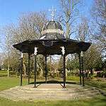
The Category B listed fountain in the park, made by the Saracen Foundry, was once on Rutherglen Main Street: it had been erected in 1897 to mark Queen Victoria's Diamond Jubilee but was moved to the park in 1911 as it had become an obstacle to the increasingly popular motor car.[56][315] The ornate bandstand (1914, also Category B listed)[316] was sited at the west side of the park[56] until it was removed in the late 1980s for the dual purpose of being used at the 1988 Glasgow Garden Festival, and to create space for the transformation of the nearby road (Mill Street) into a dual carriageway, which also involved the acquisition of a strip of land from the park and the repositioning of its ornamental iron and stone north-west gates and was completed in around 1994. By then, the bandstand had been re-sited on a grass area in the centre of the park; it has since fallen into some disrepair due to a lack of use and maintenance.[317]
 Bandstand
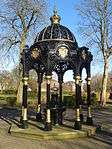 Queen Victoria fountain
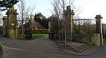 Park gates at Mill Street / Overtoun Drive
.jpg) Path and rockeries at north-west part of park
Path and rockeries at north-west part of park
The park's children's play area was extensively refurbished and extended in the 2010s,[318][319] although some original recreational features are no longer present: its red blaes football pitches disappeared entirely in the late 1980s with a care home built upon them, while the basketball hoop and red 'play train' became dilapidated and were removed, as were the tennis courts (although proposals were made by the Burnside-based Rutherglen Tennis Club in 2020 to have these restored and roofed to attract players during the winter),[320] whereas the adjacent BMX tracks have been maintained.[321][322]
The environmental charity Grow73 have their base between the bowling greens (operated as a separate club) and the BMX tracks, and they have been involved in several projects to improve its appearance and horticultural aspects,[319] including a community garden within the park;[323] there is also a Friends of Overtoun Park volunteer group with similar aims in respect of its facilities and play features.[324]
Burnside, High Crosshill and High Burnside
.jpg)
Burnside is a village within the Rutherglen boundaries which expanded into a leafy commuter suburb.[44][325] It is surrounded by several mid-20th century housing estates, in some cases modernised[326] which are within Rutherglen but not considered to be parts of Burnside as they were built to provide homes for people from other areas of the town, and from Cambuslang, who needed to be re-housed. In contrast to affluent Burnside, parts of these estates are considered to be troubled by poverty and related issues, as asserted by several versions of the Scottish index of multiple deprivation.[281][327]
Centred mostly around Stonelaw Road, Burnside has its own set of shops, church,[328] railway station and primary school. It is also home to a supermarket (once the site of a cinema)[79][329][78] and hotel with a popular bar (East Kilbride Road). There is also a bowling green, and two sets of tennis courts (previously separate clubs, they are both now operated by Rutherglen LTC).[330][331] Much of the traditional residential property was built in the early 1900s from blond and red sandstone.
The local park, Stonelaw Woods,[332][333][56] lies at the northern boundary of the village and takes its name from the demolished Stonelaw Tower (a castellated converted 18th-century coal mine winding engine house)[334] that once stood to the east of Stonelaw Road near Greystone Avenue.[335][336][337][11]
High Crosshill is a quiet residential area of wide avenues built on a steep hill between Burnside and Overtoun Park,[338] which has some views on Broomieknowe Road and includes Rutherglen Cemetery (opened 1881). High Burnside is also a residential area, consisting of high ground to the south of Burnside leading to Cathkin Braes with streets of older houses built in several eras. Some of its properties, particularly some of the oldest off Burnside Road, are very large.[44]
Spittal
.jpg)
Spittal is a post-World War II community which is almost an exclave of the town, bordering the Glasgow areas of Croftfoot to the west and Castlemilk to the south with an area of open ground to the east; it is close to the King's Park Avenue / Bankhead neighbourhood within Rutherglen to the north, but disconnected from it by the Cathcart Circle Lines railway tracks. Built on a mound used as farmland (the farmhouse was located at the junction of Carrick Road and Bute Terrace), the estate was constructed in an oval pattern of streets, with its primary school built at the highest point in the centre (completed in 1955).[44] A development of prefabs on the flatter land to the west were replaced by angular apartment blocks in the early 1970s (as also occurred at other locations including Burnhill, Bankhead and at North Halfway in nearby Cambuslang).[44] A new community centre was built in the early 21st century, close to the older small wooden church. There are also local amenities such as shops – including Post Office – on Kyle Square and a pub-restaurant, 'The Croft',[339] situated exactly on the local authority boundary at Croftfoot.
Two small burns run on either side of Spittal's housing, bordered by grassed areas – one burn runs from Castlemilk Park and the other from further east via High Burnside, both originating on the north slopes of the Cathkin Braes; these waters converge north of Spittal, flowing north to Bankhead and on to Shawfield and the Clyde where it is marked as the Cityford Burn, but colloquially known as the Jenny Burn.[340]
In 2016, the area's recreation fields bordering Croftfoot, which had been bequeathed to the community 'in perpetuity' in the 1930s but had been allowed to fall into disrepair over a number of years, were subject to planning applications for new housing.[341] The Croftfield Park development was completed about three years later.[342] A replacement modern AstroTurf football field was added adjacent to the primary school in 2019, although this was several years after the original fields were abandoned and six years after the school itself was replaced (built on its original red blaes pitch),[343] as the old buildings became the temporary home for Bankhead, St Mark's and Burnside Primaries while their facilities were also renewed.[305][344] Just south of Spittal is Kirkriggs School, a Special educational needs facility which is under Glasgow City Council control.[345]
Blairbeth and Fernhill
Blairbeth
Blairbeth is a small 1950s local authority housing scheme of tenements and modest terraced houses, generally still with the same appearance as at the time of its construction.[326] It was built around a former rural estate (the house, sited at the top of Kirkriggs Avenue, is long since demolished, as was the entrance lodge house to its north).[44] The neighbourhood has some limited local amenities[346] and small parks, as well as a school, St Mark's RC Primary – its associated church of the same name is located to the south of the housing at the edge of the neighbouring Fernhill area, which has no direct link to Blairbeth for vehicles. The designated non-denominational school for the locality is Spittal Primary, although some children attend Burnside Primary which is equally close.
Also bordering High Crosshill and High Burnside, many of the hillside streets have views over Rutherglen and Glasgow. A large flat grass field to the west of the neighbourhood[44] was popular in the summer months for football, buts its size was greatly reduced by a junction re-alignment in 2016, connecting Croftfoot Road and Blairbeth Road - previously a staggered junction via Fernhill Road with single lanes causing considerable congestion at peak times - into a single crossroads with filter lanes, as part of the Cathkin Relief Road works. To the west of this road is the boundary with the city of Glasgow, denoted visually by the twin castellated stone gates of 'Buchanan Lodge', today a nursing home but historically the north-east entrance to the driveway leading to Castlemilk House;[347][348][44] the mansion no longer exists, although most of the route through its lands (most of which are occupied by the various neighbourhoods of Castlemilk housing estate) is still present as tree-lined footpaths, managed under an award-winning conservation project.[349][350][351] A section of the estate's old boundary wall is also visible near Blairbeth, although sections are crumbling and dangerous.
Fernhill
.jpg)
Fernhill is a housing estate originally built in the 1960s, which underwent a great deal of regeneration in the 2010s.[352][326] It is home to an all-girl private school, the main building for which is the historic Fernhill mansion house. The area is bordered by the Castlemilk housing estate in Glasgow to the west,[353] as well as by Blairbeth, High Burnside and Cathkin within Rutherglen. Fernhill Road bisects the estate and is where the rebuilt local amenities (convenience stores, community centre children's play area, 5-a-side football fields)[354] are found. The estate also has two churches at either end and a decorative brick entrance wall off Burnside Road.
The Cathkin Relief Road was completed in 2017 at a cost of £21 million to extend Mill Street from Spittal through the informal parkland between Fernhill and Blairbeth/High Burnside to connect with the existing Cathkin Bypass (A730) and alleviate traffic from other local routes including Fernhill Road.[355][356][357] In 2019, Fernbrae Meadows was opened to the south of Fernhill; formerly Blairbeth Golf Course, the area is a 20 hectares of semi-natural, managed greenspace.[358]
Springhall and Cathkin
Springhall

Springhall is a self-contained 1960s local authority housing estate,[359][326] mostly consisting of a compact network of maisonettes, and featuring a community centre and library dating back to the time of the scheme's construction[360] but upgraded in 2019.[361][362] Below the original library is a small set of local shops.[359] There is also a catholic church and two local schools (St Anthony's RC Primary and Loch Primary)[363] that were rebuilt in the 2000s in a mirror image of one another and share a playground,[364][365] the playing fields for which are built on the site of a former loch (Boultrie Loch) which was popular for curling and skating in winter.[56][366] A stone sign welcomes visitors into the estate from the entrance off East Kilbride Road (the A749 road) where there is also a pub, 'The Braes' (previously the Cathkin Hotel), on the opposite side. A short way further south on the Springhall side of the A749 is the unusual white castellated villa 'Elpalet', designed by the housebuilder John McDonald (whose companies constructed thousands of new homes in Glasgow in the 1930s, including hundreds in Burnside),[367][368] to be his own residence. The property is now divided into apartments.[369][370]
A 13-storey tower block (the only building of such height in the burgh, although there are 10 towers of the same design in Cambuslang)[371] looms over the centre of the neighbourhood;[372][373] it was built on the site of the Springhall mansion house that once occupied the land,[44] which came to public attention in the 1910s, first when suffragette Frances Gordon was imprisoned for attempting to set the house on fire,[374] then soon afterwards when a contingent of Belgian refugees of World War I were invited to stay there;[375] it was demolished in the 1940s. Adjacent to the tower is a sports pitch in a wire mesh pen.
Cathkin High School, the secondary school affiliated to Loch Primary, is located nearby at the western side of the neighbouring estate of Whitlawburn – administratively this is part of Cambuslang, although shares some amenities with Springhall, with the schemes connected under the main road by a pedestrian underpass).
Cathkin
Cathkin is the southernmost and highest part of Rutherglen, largely comprising a post-World War II estate which underwent a good deal of regeneration of its housing stock in the early 21st century.[376][352][377][326] The estate borders the City of Glasgow (the Cathkin Braes Country Park) and the lands of Carmunnock, the civil parish in which it was historically located along with Fernhill and Spittal)[378] and offers views over the Greater Glasgow valley. There is a small wooded area, Cathkin Woods, near the neighbourhood's eastern boundary with Whitlawburn. Limited amenities include a primary school with community facilities,[379] and a church (located a short way into Fernhill and designed to serve both communities, as was the school) while local shops off Cathkin Bypass / Cuillins Road feature a supermarket, newsagent and betting shop. Like many parts of the town, a new stone and metal entrance sign welcomes visitors entering Cathkin from the bypass road.
The grounds of the old Cathkin House mansion[45][44] (built 1799, and a children's home in the later 20th century)[380][381][382] now converted to apartments, offers views over Rutherglen and Glasgow beyond. The mansion is surrounded by small separate residential developments, primarily of large villas, which also enclose around the buildings of Mid Farm, one of the oldest surviving properties in the area. The ancient Burnside Road at that location no longer connects for vehicular traffic with Cathkin Road (the rural B759 running between the A749 East Kilbride Expressway and Carmunnock village, via Cathkin Braes Park and Cathkin Braes Golf Club).
Education
Loch Primary and Cathkin Primary are feeder schools for Cathkin High School (built in 1970, rebuilt in 2008),[383][384] which is located at Whitlawburn just outside the Rutherglen boundaries and is primarily the secondary school for Cambuslang. Conversely, two schools located in Cambuslang (James Aiton and Park View) are feeders for Stonelaw High in Rutherglen, as is Toryglen Primary in Glasgow plus Bankhead, Burgh, Burnside, Calderwood and Spittal Primaries within the burgh.
Trinity High (to which St Anthony's, St Mark's and St Columbkille's Primaries are affiliated) is the only Catholic secondary school for both towns, as is the case for Rutherglen High School, the local Additional Support Needs facility which shares a campus with Cathkin High.[385][386]
All council-run schools in the South Lanarkshire area were rebuilt between the late 1990s and 2010s.[387]
List of schools
2019-20 pupil roll in parentheses.[388]
Non-denominational
- Bankhead Primary School, Bankhead Road, Rutherglen, G73 2BQ (332)
- Burgh Primary School, 41 King Street, Rutherglen, G73 1JY (199)
- Burnside Primary School, Glenlui Avenue, Burnside, Rutherglen, G73 4JE (393)
- Calderwood Primary School, Buchanan Drive, Rutherglen G73 3PQ (435)
- Cathkin Primary School, Burnside Road, Rutherglen, G73 4AA (213)
- Loch Primary School, Lochaber Drive, Springhall, Rutherglen, G73 5HX (190)
- Spittal Primary School, Lochlea Road, Spittal, Rutherglen G73 4QJ (137)
- Stonelaw High School, 140 Calderwood Road, Rutherglen, G73 3BP (1107)
Roman Catholic
- St Anthony's Primary School, Lochaber Drive, Springhall, Rutherglen, G73 5HX (205)
- St Columbkille's Primary School, Clincarthill Road, Rutherglen, G73 2LG (293)
- St Mark's Primary School, Kirkriggs Avenue, Blairbeth, Rutherglen, G73 4LY (151)
- Trinity High School, Glenside Drive, Eastfield, Rutherglen, G73 3LW (1100)
Private schools
- Fernhill School, Fernbrae Avenue, Fernhill, Rutherglen, Glasgow, G73 4SG (230 – 5 to 18)
Sport
Football
Rutherglen Glencairn F.C. play in the West Region of the Scottish Junior Football Association. The club was formed in 1896 and has won the famous Scottish Junior Cup on four occasions (1901–02, 1918–19, 1926–27, 1938–39).[389] Glencairn moved into a brand new stadium (New Southcroft Park, currently sponsored by Celsius Cooling and renamed as The Celsius Stadium) situated in the Burnhill area of Rutherglen in 2009[291] following the demolition of the old ground (Southcroft Park), where they had played for over 100 years. The Glencairn Venue building on Glasgow Road, which is on part of the old site[291] – the rest now being under the M74 motorway – is owned by the football club, although the company operating in the building is a separate entity from the club. In 2008, Rutherglen Glencairn won the Central District League First Division with a record points total. The 2009–10 season saw Glencairn record back to back titles when they won the West Region Super League Division One at the first attempt.
Clyde Football Club used to play in the area before moving to the former new town of Cumbernauld. The immediate area could be considered the cradle of Scottish football, with Hampden Park, the national stadium and home to Scotland's oldest football club Queen's Park being close by to the west as well as Cathkin Park, the home of the defunct Third Lanark and not far to the north, Celtic Park, the home of Celtic – all of which (apart from Clyde's former ground) are located in the City of Glasgow.
In addition to men's amateur teams (such as Rutherglen AFC of the Scottish Amateur Football League), the town also has a women's football club: Rutherglen Girls FC was founded in 2012 and currently features three age group teams plus a senior Ladies team competing in the SWFL Division 2 - West/South West league.
Notable people
- Several notable persons born between 1978 and 1998 are 'from' Rutherglen as per their birth certificate, but have only a tenuous link to the town due to being delivered at Rutherglen Maternity Hospital which operated between these years;[139][138][140][141] many children born here would have grown up in Glasgow, East Kilbride or elsewhere.[390] This applies to international footballers Craig Bryson, Stuart Findlay, Declan Gallagher, Steven Hammell and Aiden McGeady, additionally footballers Chris Erskine, Fraser Kerr, Willie Howie, Dave Mackay, international rugby players Richie Gray and Jonny Gray, and golfer Marc Warren. Others with clear ties to Rutherglen are listed below.
Artists, actors and media personalities
- Dave Anderson, actor, musician and playwright
- Janet Brown, actress and comedian, known for her impressions of Margaret Thatcher[6]
- Steven Campbell, artist
- Andy Cameron, comedian[391]
- Robbie Coltrane, comedian/actor[6]
- Dougie Donnelly, sports TV presenter[392]
- Gary Erskine, comic artist
- Jack Jester (born Lee Greig), professional wrestler, former ICW heavyweight champion
- Jayd Johnson, actor[393]
- Scott Kyle, actor[394]
- George Logan, Hinge and Bracket television comedy double act
- Mamie Baird (née Baird), journalist; married TV broadcaster Magnus Magnusson, their family home was in the town and was where children Jon Magnusson (producer) and TV news presenter Sally Magnusson grew up[254]
- Alistair MacLean, television script writer, teacher at Gallowflat High School
- Tom McGrath (playwright)[6]
- Matt McGinn, folk singer, born in the Calton but lived in Rutherglen for many years, wrote songs which mention Rutherglen, like "Ru'glen Jean" and "Rosy Anna"
- Edwin Morgan, poet
- Frank Quitely, (born Vincent Deighan), comic artist
- Richard Rankin, actor and comedian (born Richard Harris), starred in popular TV shows such as Burnistoun, Taggart and Outlander[395]
- Audrey Tait, drummer of hip-hop band Hector Bizerk
- Dougie Thomson, the bass guitarist for Supertramp from 1972-1988
- Midge Ure of the band Ultravox[396]
Politicians
- Marie Cassidy, State Pathologist for Ireland
- David Fleming, politician
- Clare Haughey, SNP MSP (for Rutherglen)
- Gerard Killen, Labour MP (for Rutherglen)
- John Mason, SNP MSP
- Baron Tommy McAvoy Labour politician, House of Lords Life peer
- Eddie McAvoy, leader of South Lanarkshire Council, brother of Baron McAvoy
- John Campbell White, also known as Baron Overtoun / Lord Overtoun,[11][13] son of James White, also partner in the Whites firm. His successor William James Chrystal is mentioned in a plaque on Main Street for contributions towards the Old Parish Church.[11][397]
Sportspersons
- Steve Archibald, Scotland international footballer, clubs included Tottenham, Barcelona
- Archie Baird, footballer (Aberdeen) and World War II POW
- Alec Bennett (Celtic, Rangers and Scotland footballer)
- Bob Davidson, footballer (Dundee)
- Paul di Giacomo, footballer (Kilmarnock)
- Simon Donnelly, international footballer (Celtic)
- Stuart Dougal, football referee
- Jimmy Dunn footballer (Leeds United)
- Scott Forrest, Commonwealth Games rugby international
- Allan Forsyth, footballer (Dundee United)
- Alistair Galloway, volleyball player (Scotland and Great Britain)
- Mary Gilchrist, chess player
- Tommy Grozier, footballer (Plymouth Argyle)
- Brogan Hay, footballer[398]
- Drew Henry, snooker player
- Harry Haddock, international footballer (Clyde)
- Archie Jackson, Australian cricketer
- Colin Jackson (Rangers and Scotland defender), born in Glasgow and raised in Aberdeen but lived in Rutherglen for most of his life
- Thomas Leather, Australian cricketer
- Collette McCallum, international footballer player for Australia[399]
- Amy McDonald, international women's footballer[400]
- Jimmy McMenemy, Celtic and Scotland footballer (won 11 league titles and 7 Scottish Cups)
- Stephen McKeown, footballer (Partick Thistle)
- Brian McPhee, footballer (Airdrie)
- Bobby Murdoch, Celtic midfielder (one of the Lisbon Lions); in 2016 a plaque and display was unveiled at the Town Hall honouring his achievements[401]
- Billy Murdoch, brother of Bobby, played for Kilmarnock
- John Moir, American basketball champion
- Jack Mowat, football referee, oversaw 12 domestic cup finals and the 1960 European Cup Final
- Willie Robb, international footballer (Rangers)
- Peter Roney, footballer (Bristol Rovers)
- Steven Saunders, international footballer (Motherwell)
- Sandy Stewart, footballer (Airdrie)
- Dick Strang, footballer (Darlington)
- David Syme, football referee
- Alan Trouten, footballer
- Duncan Weir, Scotland international rugby union player, began career at Cambuslang Rugby Club
- Andy Walker, Celtic footballer and TV presenter
Others
- John Dickson (minister) Covenanting field preacher and prisoner for 6 years on the Bass Rock
- William Gemmell Cochran, statistician[6]
- Dr James Burn Russell, Chief Medical Officer for Scotland at the turn of the 20th century, lived in Rutherglen for many years[402][403]
- Jonathan Saunders, fashion designer[404]
- Bob Taggart (1900-2009), briefly Britain's Oldest Man[405][406]
- James White, lawyer and a partner in J & J White Chemicals (statue in Cathedral Square, Glasgow)
References
- "List of UK post towns". Evox Facilities. Archived from the original on 19 February 2012. Retrieved 22 February 2012.
- "New Local Government areas". Hansard. 22 October 1973. Retrieved 4 November 2018.
- Irene Maver. "Modern Times: 1950s to The Present Day > Neighbourhoods". The Glasgow Story. Retrieved 4 November 2018.
- "Scotland's Landscape: City of Glasgow". BBC. Retrieved 4 November 2018.
- Rutherglen residents not interested in Glasgow return, Daily Record, 9 April 2017
- Local and family history: Rutherglen - history in the making, South Lanarkshire Council
- The Statistical Account of Lanarkshire (page 373), Society for the Benefit of the Sons and Daughters of the Clergy, W. Blackwood, 1841, Harvard University
- Farme, Old Country Houses of the Old Glasgow Gentry (1878)
- "Rutherglen Lanarkshire". A Vision of Britain through Time. Retrieved 15 August 2018 – via University of Portsmouth.
- OS 25 inch Scotland, 1892-1905, Explore georeferenced maps (National Library of Scotland)
- An A to Z of Rutherglen Then and Now, Bill McLennan, Rutherglen Heritage Society, 2018
- Scientists propose five drilling sites in Rutherglen to prove disused mines hold key to heating homes, Daily Record, 25 April 2018
- Overtoun Park should be stripped of its name, MP says, Daily Record, 27 March 2019
- An ancient and peculiar Rutherglen custom: The Making of St. Luke's Cakes, The Anecdotage of Glasgow, Robert Alison, 1892, via Electric Scotland
- History of Drinking: The Scottish Pub since 1700, Anthony Cooke, Edinburgh University Press, 2015, ISBN 9781474407366
- Main St Rutherglen, 1895, Virtual Mitchell
- Old Photograph Horse Fair Rutherglen Scotland, Tour Scotland
- "Mid-2016 Population Estimates for Settlements and Localities in Scotland". National Records of Scotland. Retrieved 27 June 2019.
- "List of railway station names". Newsnetscotland.com. 18 August 2011. Retrieved 16 November 2012.
- An Ruadh-Ghleann, Wetherspoons
- "Ainmean-Àite na h-Alba - Gaelic Place-Names of Scotland - Database". Gaelicplacenames.org. Retrieved 16 November 2012.
- Election 2019: Rutherglen & Hamilton West BBC News, 13 December 2019
- Kerr, Aiden (9 June 2017). "Labour gain first Scottish seat from SNP in election". STV Group. Retrieved 11 July 2017.
- Spooner, Murray (9 June 2017). "Labour takes Rutherglen and Hamilton West". Daily Record / Rutherglen Reformer. Trinity Mirror. Retrieved 11 July 2017.
- "Election 2015: Rutherglen & Hamilton West". BBC News. 8 May 2015. Retrieved 11 July 2017.
- Dickie, Douglas (8 May 2015). "Rutherglen and Hamilton West election results: SNP's Margaret Ferrier takes Labour hotspot with 52 per cent of the vote". Daily Record / Rutherglen Reformer. Trinity Mirror. Retrieved 11 July 2017.
- "Scottish Parliament election 2016 constituency result: Rutherglen". The Scotsman. 6 May 2016. Retrieved 11 July 2017.
- Boundary changes create new Rutherglen seat, but area remains in Glasgow region, Daily Record, 2 June 2010
- "Map ward 12 - Rutherglen Central and North" (PDF). South Lanarkshire Council. 4 May 2017. Retrieved 23 July 2018.
- "Rutherglen Central and North". Police Scotland. Retrieved 23 July 2018.
- "South Lanarkshire". City Population. 30 June 2016. Retrieved 23 July 2018.
- "Map ward 11 - Rutherglen South" (PDF). South Lanarkshire Council. 4 May 2017. Retrieved 13 March 2020.
- "Ward map 13 - Cambuslang West" (PDF). South Lanarkshire Council. 4 May 2017. Retrieved 13 March 2020.
- "Map ward 14 - Cambuslang East" (PDF). South Lanarkshire Council. 4 May 2017. Retrieved 13 March 2020.
- Shock stats show Rutherglen has more unemployment, highest rate of alcohol and drug admissions and more social work referrals than anywhere else in South Lanarkshire, Daily Record, 19 December 2018
- "Frequency Guide" (PDF). First Glasgow. 1 January 2018. Retrieved 10 March 2020.
- "Glasgow Network Map" (PDF). First Glasgow. 1 January 2018. Retrieved 10 March 2020.
- Rutherglen made an Air Quality Management Area after pollution levels exceed national guidelines, Daily Record, 14 December 2015
- Rutherglen named as pollution hotspot, Daily Record, 7 February 2018
- Rutherglen town centre listed as one of South Lanarkshire's worst areas for air pollution, Daily Record, 28 January 2020
- Military Maps of Scotland (18th century): Roy Lowlands, 1752-55, Explore georeferenced maps (National Library of Scotland)
- Northern Part of Lanarkshire. Southern Part. Top section, John Thomson's Atlas of Scotland, 1832 (National Library of Scotland)
- Rutherglen Conservation Area: Character Appraisal, South Lanarkshire Council, 2008
- OS National Grid Maps, 1944-1967, Explore georeferenced maps (National Library of Scotland)
- OS Six-inch 1st edition, 1843-1882, Explore georeferenced maps (National Library of Scotland)
- Rutherglen main street is webcam wonder, BBC News, 14 December 2009
- Campaign for return of popular Rutherglen webcam, Daily Record, 19 December 2017
- Rutherglen Town Hall, Dictionary of Scottish Architects
- Portfolio: Rutherglen Town Hall, Honeyman Jack & Robertson Chartered Architects
- How Rutherglen Town Hall was brought back to its best, Daily Record, 4 March 2015
- Rutherglen Town Hall: 10 Reasons To Choose This Scottish Wedding Venue, White Rose Wedding Venues
- "Rutherglen Town Hall". South Lanarkshire Leisure and Culture.
- Licensing and Registration Office - Rutherglen, South Lanarkshire Council
- Grave concern over historical Rutherglen site, Daily Record, 24 April 2013
- "The Historical Background to the Site of Rutherglen Old Parish Church". Rutherglen Old Parish Church.
- Old Rutherglen, Rhona Wilson (Stenlake Publishing, 1996) ISBN 9781872074726
- Glasgow, Rutherglen, Main Street, Rutherglen Old Parish Church, Rutherglen Tower And Fragments Of Old Church, Canmore
- Dr Gorman Statue Undergoing Restoration, Daily Record, 13 March 2013
- 20-24 Queen Street and 115 King Street, Masonic Hall, British Listed Buildings
- Lodge Rutherglen Royal Arch 116, Glesca Pals
- 159, 161, 163 Main Street, Rutherglen, Post Office and Library, Historic Envirnment Scotland
- Carnegie Libraries: Scottish Style, Scotcities
- No parking at Rutherglen town hall, Daily Record, 11 February 2009
- Rutherglen post office finally open again, Daily Record, 3 December 2018
- Historic Library Tour: Sat 8th August 2015 2-3pm, Rutherglen Heritage
- Rutherglen Lore, Tennent Family Website
- New Display : William R Shearer & Rutherglen Lore, Rutherglen Heritage Society, 27 October 2015
- Rutherglen Library officially opened, Daily Record, 24 March 2010
- Glasgow, Rutherglen, Town Hall, Canmore
- Rutherglen Salvation Army Major reckons organisation is just as relevant now as when it was started, Daily Record, 12 July 2015
- Glasgow, Rutherglen Castle, Canmore
- Museums: Browse the Collection (King Street), South Lanarkshire Leisure and Culture
- Burgh of Rutherglen Fire Brigade, The History of Scottish Fire Brigades
- Glasgow, Rutherglen, Main Street, St Columbkille's Roman Catholic Church, Canmore
- "Parish History". St Columbkille's Church Rutherglen.
- SCIAF to mark 50th anniversary at St Columbkilles, Daily Record, 25 January 2015
- St Columbkilles Church Hall, Rutherglen, CRGP Limited
- Rutherglen's movie hall past, Daily Record, 2 September 2009
- The Picture Houses of Rutherglen, Rutherglen Heritage Society, 2020
- Rutherglen cinemas, Scottish Cinemas and Theatres Project
- East Church, Rutherglen, Reformed Presbyterian Church, GENUKI
- Glasgow, Rutherglen, 18 Farmeloan Road, Rutherglen East Church, Canmore
- Rutherglen East Church remembered after pictures belonging to old minister give snapshot to the past, Daily Record, 8 March 2015
- Talks could lead to permanent base for Rutherglen community trust, Daily Record, 8 May 2014
- Number 18, What's On Lanarkshire
- Rutherglen church marks 114th anniversary of founding, Daily Record, 31 May 2015
- Brief History, Rutherglen Congregational Church
- History, Rutherglen Repertory Theatre
- Police plan to take over former Rutherglen courthouse, Daily Record, 19 January 2018
- Rutherglen’s Planning, Building Standards and Roads Office move to East Kilbride, Daily Record, 23 March 2011
- Royal Burgh House - 380 King Street, Showcase Property
- Rutherglen Evangelistic Institute, The Scottish Military Research Group - Commemorations Project, 22 December 2010
- Right Hon. Baron Overtoun, 100 Glasgow Men (1909)
- History, Smith and Rodger Ltd
- Rutherglen Evangelistic Institute, Scotland's War
- WWI letter sent to Rutherglen troops in 1916 is unearthed ahead of Armistice Day, Daily Record, 2 November 2018
- Rutherglen, Scotland - December 29 2017: The back view of the Old Burgh Primary School and the Rutherglen Evangelistic Institute., Alamy
- King Street, Burgh Primary School with Boundary Walls, Railings and Gatepiers, British Listed Buildings
- Site of former Burgh Primary School will soon be open for business, Premier Construction News, 23 December 2011
- Burgh Business Centre, Urban Realm, 2012
- Rutherglen nursery overwhelmed by response of community, Daily Record, 6 March 2014
- Burgh Primary holds official opening, Daily Record, 7 April 2010
- Memories of the Academy, Rutherglen Reformer, 21 March 2018,via PressReader
- Glasgow, 255 King Street, Rutherglen United Presbyterian Church, Canmore
- Rutherglen UP Church (Glasgow University Library, Theology, 1875), The Glasgow Story
- Cool welcome in Rutherglen arcade, Daily Record, 14 March 2018
- Our Stores, Rutherglen Exchange Shopping Centre
- New Rutherglen business centre is officially opened, Daily Record, 17 July 2011
- Refurbishment completes on Rutherglen's Greenhill Court, Urban Realm, 16 June 2013
- Case Study: Greenhill Court, Rutherglen, Lovell Partnerships
- Rutherglen flats not a "troubled block" despite reported violence, drug abuse and bullets, Daily Record, 21 June 2017
- Adding heritage ingredient to the taste of success, Glasgow Herald, 3 February 1990
- Our World, Paterson Arran
- The beautiful game is always in vogue here, Daily Record 5 September 2012
- Linn O Dee, Old Glasgow Pubs
- Licensing board member pledges “vigilance” at prospective Rutherglen Wetherspoons, Daily Record, 29 January 2012
- Main Street, Rutherglen, Old Glasgow Pubs
- Pubs in Rutherglen, Pubs Galore
- Up and down the main street, I might have a glass of beer, 16 December 2012
- Long-serving Rutherglen and Cambuslang Housing Association chairwoman stands down after 30 years Long-serving Rutherglen and Cambuslang Housing Association chairwoman stands down after 30 years, 15 December 2015
- How the Great Storm of 1968 impacted on Rutherglen and Cambuslang, Daily Record, 12 January 2018
- About Us…, Rutherglen and Cambuslang Housing Association
- Rutherglen woman who helped start housing association honoured by Queen, Daily Record, 2 January 2018
- Rutherglen and Cambuslang high-rise residents told cladding is not the same as Grenfell, Daily Record, 7 July 2017
- Rutherglen and Cambuslang facing huge housing crisis, Daily Record, 21 February 2017
- Rutherglen, RailScot
- Rutherglen (1st), RailScot
- Rutherglen (2nd), RailScot
- Rutherglen (3rd), RailScot
- Rutherglen (4th), RailScot
- Artistic mural on Rutherglen's rich history is unveiled at train station, Daily Record, 21 November 2018
- Home, The Busy Bees
- Rutherglen mosque promises to sort out parking problems outside their building, Daily Record, 6 November 2015
- Throwback Thursday: New St Columbkille's Primary opened its doors..., Daily Record, 26 March 2016
- Children were abused for decades in Catholic homes, Scottish inquiry finds, The Guardian, 11 October 2018
- Gran breaks 65 year silence on horrifying abuse by nuns in Rutherglen kids' home, Daily Record, 31 October 2018
- For Glasgow’s Greater Good, NHS Scotland, December 2003
- GPs plan takeover of hospital which is facing early closure, The Herald, 21 October 1997
- Hospital may be sacrificed | Rutherglen Maternity could close early to save debt-ridden Victoria Infirmary, The Herald, 18 June 1997
- Rutherglen Maternity remembered through Facebook page, Daily Record, 11 May 2011
- Olde Glasgow Hospitals, Glasgow Punter, 15 December 2017
- Record and images for Dalmarnock Bridge, Canmore
- Record and images for Dalmarnock Railway Bridge (1897), Canmore
- Farme Castle (Glasgow University Library, Special Collections, Dougan Collection, 1870), The Glasgow Story
- Museum appeals for info on Rutherglen Farme Colliery, Daily Record, 14 July 2010
- Newcomen engine (Museum of Transport, c. 1905), The Glasgow Story
- 1910 Housing Conditions of Miners: Farme Coal Co, Ltd, Rutherglen, Scottish Mining Website
- Welcome, Rutherglen Links Business Park
- Farme Cross, Rutherglen Heritage Society, 2018
- Rutherglen's Royalty Boundary Stones, Rutherglen Heritage Society, 2018
- Public Sculpture, JosephIngleby.com
- Rutherglen: Farme Cross - May 2012, Album at Flickr, May 2012
- Glasgow, Dalmarnock Road, Dalmarnock Power Station, Canmore
- Dalmarnock Road Power Station, Glesga Pals
- Dalmarnock Power Station (1955), The Glasgow Story
- Homes planned for Dalmarnock Power Station site, BBC News, 28 April 2015
- Industrial East End, Parkhead History
- Shopping centre's industrial past remembered, Evening Times, 28 October 2013
- Caledonian Pottery Co Ltd, Rutherglen, Scotland's Brick Manufacturing Industry
- Hartley's history in Rutherglen, Daily Record, 27 July 2011
- Caledonian Pottery Ltd, Rutherglen Heritage Society, 2020
- Rutherglen pottery on show at museum, Daily Record, 28 November 2012
- Marking 100 years of success, Evening Times, 13 February 2016
- 88. James Stirling, Memoirs and portraits of one hundred Glasgow men (1886)
- Hugh Alexander, Index of Glasgow Men (1909)
- Unicone Co, Grace's Guide
- James Menzies and Co, Grace's Guide
- Glasgow, Dalmarnock Road, Phoenix Tube Works, Canmore
- Glasgow, Rutherglen, 119 Cambuslang Road, Eastfield Ropery, Canmore
- Glasgow, 1 Lloyd Street, Clyde Patent Wire Rope Works, Canmore
- Museums : Browse the Collection : image of Farme Cross looking along Dalmarnock Road, with the Clyde Patent Rope Wire Works (Allan Whyte & Co. Ltd.) on the left - 24 March 1925, South Lanarkshire Leisure and Culture
- Clyde Paper Co, Grace's Guide
- Glasgow, Clyde Paper Mill, Canmore
- Scotland's Lost Industries, Michael Meighan, Amberley Publishing Limited, 2012, ISBN 9781445624013
- Rutherglen Brickworks, Farme Cross, Rutherglen, South Lanarkshire, Scotland's Brick Manufacturing Industry
- Monogram site proposal could bring over 200 jobs to Rutherglen, Daily Record, 8 August 2012
- Ekco CR32 Car Radio, Allan's Virtual Radio Museum
- Unemployment, Rutherglen, Hansard, 19 December 1967
- Disastrous Inundation at Rutherglen, Ashburton Guardian, 15 April 1903, via Papers Past (National Library of New Zealand
- Rutherglen (Potentially Vulnerable Area 11/14), Clyde and Loch Lomond Local Plan District, Scottish Environmental Protection Agency, 2014
- Glasgow, 5-9 Dalmarnock Road, Sanmex Chemical Works, Canmore
- Rutherglen dealt major jobs blow as Sanmex announce plans to leave the Burgh, Daily Record, 13 July 2016
- Speyside wins funds for Asian expansion, The Speyside distillery
- Huge housing development planned for former distillery site in Rutherglen, Daily Record, 29 May 2018
- Land for sale in 5-21, Dalmarnock Road, Rutherglen, Glasgow, Scotland G73, PrimeLocation
- McDonald's plan Rutherglen opening in latter part of 2015, Daily Record, 14 January 2015
- Commercial property for sale in Clyde Gateway Trade Park, Rutherglen, Glasgow G73, PrimeLocation
- Rutherglen Links, Clyde Gateway
- Regeneration plans for business sites near Rutherglen, BBC News, 4 December 2012
- £15m business district gets the green light, Evening Times, 6 December 2012
- Ford Retail brings Scottish hub to Rutherglen business park, The Scotsman, 28 February 2019
- Rutherglen Links Business Park enters final stages, Scottish Construction Now, 26 June 2019
- Clyde Gateway showcase One Rutherglen Links, Urban Realm, 16 February 2015
- One Rutherglen Links is open for business as Clyde Gateway look to attract new companies to the area, Daily Record, 16 February 2015
- Rutherglen Links business park expands with twin pavilions, Urban Realm, 30 May 2019
- "Two 74". Ashfield Land. Retrieved 11 July 2018.
- "Green light for £15m mixed use development in South Lanarkshire". Scottish Construction Now. 17 February 2016. Retrieved 11 July 2018.
- "Rutherglen's Two74 project faces delay". Daily Record / Rutherglen Reformer. 15 September 2016. Retrieved 11 July 2018.
- Construction work underway on new golf complex for Rutherglen and Cambuslang, Daily Record, 3 March 2020
- Glasgow, Rutherglen, Farme Cross, Millar Terrace, Canmore
- Glasgow, Rutherglen, Farme Cross, Carlyle Terrace, Canmore
- How the colonies became an Edinburgh institution, Edinburgh Evening News, 25 July 2017
- Rutherglen, Miller Terrace General view from NE, Canmore
- Rutherglen, Parkhead History
- Tennent's, Old Glasgow Pubs
- New community pub on Rutherglen block to take centre stage on local entertainment, 23 March 2019
- Rutherglen’s new Kingdom Hall taking shape, Daily Record, 12 October 2011
- Local Bowling Clubs, Cambuslang Bowing Club
- "Cuningar Loop - Forestry and Land Scotland". forestryandland.gov.scot.
- Shawfield, Old Country Houses of the Old Glasgow Gentry (1878)
- "Toxic fears over M74 extension (The Herald, 2003)".
- "£24m identified for second phase of chromium cleanup at Shawfield (Clyde Gateway news, 2016)".
- £2million plan to clean up Shawfield, Daily Record, 8 February 2019
- "Harmful chemicals in green Glasgow burn to be flushed". BBC News. 19 February 2019. Retrieved 4 March 2020.
- "Polmadie Burn: 'Erin Brockovich' River Clyde toxic disaster 'poses no risk to public'". Evening Times. 8 March 2019. Retrieved 4 March 2020.
- "Clyde Gateway – National Business District Shawfield".
- Shawfield masterplan wins £6m European funding, Urban Realm, 3 December 2012
- New £9 million Rutherglen office building brings 170 jobs to local area, Glasgow Live, 8 July 2019
- "Grace's Guide – Thomas B. Seath".
- Seath's Shipyard, Rutherglen Heritage Society, 2018
- Clyde Smartbridge readied for weeknd opening, Urban Realm, 17 July 2014
- Holistic landscape design will be essential to successful regeneration, LUC Consultancy
- Is this Scotland's steepest street?, BBC News, 28 August 2019
- Rutherglen church set to celebrate 175th anniversary, Daily Record, 19 January 2011
- New minister of Rutherglen West and Wardlawhill Church calls for focus on love and acceptance - and to bring the church into modern times, Daily Record, 25 June 2017
- Rutherglen church to be transformed into Hindu Temple, Daily Record, 7 April 2010
- Rutherglen Wardlawhill Parish Church, The Scottish Military Research Group - Commemorations Project
- "I hated school so much I pulled it down". Sunday Mail. 1 April 2001. Retrieved 5 March 2020 – via The Free Library.
- Dickie, Douglas (25 October 2017). "Former pupil who redeveloped old Rutherglen Academy building arranges school reunion". Daily Record / Rutherglen Reformer. Retrieved 5 March 2020.
- Dickie, Douglas (11 April 2012). "Stonelaw head looks back on 32 terrific years in Rutherglen". Daily Record / Rutherglen Reformer. Retrieved 4 March 2020.
- "Stonelaw High School: About Us". Stonelaw High School. Retrieved 4 March 2020.
- History, St. John Operative 347
- History, Lodge Toryglen No 1561
- Museums: Browse the Collection (Hamilton Road), South Lanarkshire Leisure and Culture
- Gallowflat Mound, Gazetteer for Scotland
- Rutherglen, Gallowflat, Canmore
- Gallowflat House (Glasgow University Library, Special Collections, Dougan Collection, 1870), The Glasgow Story
- Gallowflat Old Country Houses of the Old Glasgow Gentry (1878)
- "Making your fellow pupils cross". The Herald. 13 January 2016. Retrieved 4 March 2020.
- Rebuilding Gallowflat School, Rutherglen Heritage Society
- Hamilton rd, 11th March 2009,Gallowflat School, via Urban Glasgow
- Hamilton rd,10th July 2009, David Walker Gardens, via Urban Glasgow
- "David Walker Gardens". RIAS. Retrieved 4 March 2020.
- "David Walker Gardens open its doors". Daily Record / Rutherglen Reformer. 30 March 2011. Retrieved 4 March 2020.
- Williams, Stratton (5 October 2015). "Plans to turn the old Stonelaw High into flats given green light". Daily Record / Rutherglen Reformer. Retrieved 4 March 2020.
- Kenealy, Edel (20 July 2017). "Plans for Rutherglen's Gallowflat school still on the table". Daily Record / Rutherglen Reformer. Retrieved 4 March 2020.
- Rutherglen bowls champion determined to equal club legend's record of nine championship wins, Daily Record, 4 October 2017
- About Us, Rutherglen Bowling Club
- Church's project opens up the past, The Herald, 14 January 2014
- Stonelaw Church opens time capsule from 1912 at special service, Daily Record, 16 January 2014
- Revamp proposed for Stonelaw Church, Rutherglen Reformer, 14 March 2018, via PressReader
- Bowls: Overtoun Park celebrating 100 years, Daily Record, 25 April 2012
- Vandals leave Rutherglen bowling green like 'bomb site', Daily Record, 7 April 2016
- "Templeton Bowling Club hold summer fett [sic]". Daily Record / Rutherglen Reformer. 16 June 2010. Retrieved 7 February 2018.
- Burnside grandfather is honoured as care home named after him, Daily Record, 10 October 2018
- Templeton House, Abbeyfield
- Concern over old Langside College campus plans in Rutherglen, Daily Record, 6 February 2014
- Memories: pupils learn to use green fingers in Rutherglen in 1954, Evening Times, 26 March 2015
- "Stonelaw Community Sports Hub". Retrieved 9 February 2018.
- "Stonelaw Community Sports Centre". South Lanarkshire Leisure & Culture. Retrieved 9 February 2018.
- Pupil rolls across Rutherglen and Cambuslang continue to rise, Daily Record, 24 March 2017
- Glasgow, Burnside, Buchanan Drive, Calderwood Primary School, Canmore
- Schools and Nurseries (catchment area: Calderwood Primary School), South Lanarkshire Council
- Cambuslang Industrial History, 2013, via DocPlayer
- Eastfield House, Old Country Houses of the Old Glasgow Gentry (1878)
- Smith, Kenny (7 August 2010). "New Trinity High is officially opened". Daily Record / Rutherglen Reformer. Retrieved 5 March 2020.
- "SLC – Eastfield Lifestyle". South Lanarkshire Leisure & Culture. Retrieved 7 March 2020.
- Proposed changes to popular Rutherglen pub will "rip the heart out of the community", Daily Record, 12 September 2018
- "Inside Cambuslang's Clydebridge steelworks". Daily Record / Rutherglen Reformer. 11 May 2011. Retrieved 2 March 2020.
- A £15m Hotel Plan for its Clydebridge Site Revealed by Steel Giant Liberty, The Leaders Globe, 13 January 2020
- "Malls Mire Community Woodland". Urban Roots. Retrieved 9 March 2020.
- "Malls Mire Community Reserve". Woodland Trust. Retrieved 9 March 2020.
- Will Henshaw (1 June 2015). "Toryglen's Urban Roots celebrate as Malls Mire gains local nature reserve status". Daily Record. Retrieved 9 March 2020.
- Old Photograph Burnhill Rutherglen Scotland, Tour Scotland
- 3 Western Avenue, Rutherglen West Parish Church (Munro Church) Church of Scotland, British Listed Buildings
- Glasgow, Rutherglen, Western Avenue, Munro Free Church, Canmore
- A Brief Biography of George Henry Paulin, Air Comm. Marcus Wetherspoon
- Rutherglen, The Scottish Military Research Group - Commemorations Project
- Rutherglen community welcome off-sales KO, Daily Record, 12 June 2014
- More sickening sectarian graffiti painted in Rutherglen underpass, Daily Record, 12 October 2017
- Rutherglen and Cambuslang areas among Scotland's poorest, according to Scottish Index of Multiple Deprivation stats, Daily Record, 12 February 2020
- Cops vow to crack down on underage drinkers in Burnhill, October
- Burnhill Action Group, Locator (Voluntary Action South Lanarkshire)
- Lottery cash is a godsend, Rutherglen Reformer, 27 February 2019, via PressReader
- Thugs making life miserable for Rutherglen's Burnhill community, Daily Record, 26 April 2017
- Still Game at Rutherglen pub, Daily Record, 22 February 2018
- Fairways, Old Glasgow Pubs
- A history of Toryglen Golf Club, Rutherglen, Rutherglen Heritage Society, October 2018
- "Toryglen". Forgotten Golfing Greens of Scotland. Retrieved 22 October 2018.
- Ye Old Inn, Old Glasgow Pubs
- Rutherglen Glencairn Football Club, Glasgow Architecture, 16 October 2008
- Burnhill Sports Centre in Rutherglen facing the axe as South Lanarkshire Council look to balance budget Daily Record, 3 December 2015
- Burnhill Sports Centre demolished as council says no current plans for chromium probe, Daily Record, 9 August 2017
- Cathkin Laundry site is cleared, Daily Record, 27 February 2013
- 2640 Westfield; Rutherglen, Curling Places Vol 2
- History, Carmunnock & Rutherglen Curling Club
- Former Rutherglen nursery to become social housing, Daily Record, 4 April 2017
- Housing association given keys to its new £4.5 million development, Rutherglen Reformer, 19 June 2019, via PressReader
- Step back in time at Rutherglen Library, Daily Record, 7 March 2015
- Muirbank House, Bankhead, Rutherglen Home of Thomas Nelson & Margaret Blair Ross, Our Roots
- The Old Quarry Bar, Rutherglen, Glasgow, Pubs Galore
- Bigots target Rutherglen club on eve of march, Daily Record, 6 July 2011
- UK: Voting In Four By-Elections In Britain Seen As General Election Pointer. Opposition Share Of Poll Increases 1964, British Pathé (video footage - polling station at Farie Street School)
- "Kings Park, Glasgow - origins & history". Glasgow's South Side. Retrieved 13 February 2018.
- Newly-built £8.8million Bankhead Primary School is a real class act, Daily Record, 9 June 2015
- "State Cinema". The Glasgow Story. Retrieved 13 February 2018.
- "State / County, Glasgow". The Scottish Cinema Project. Retrieved 9 September 2018.
- Flats plan for former library, Daily Record, 4 January 2012
- Car park will ease problems in Quigley's, Daily Record, 24 April 2013
- Average speed cameras to go live in Rutherglen accident hotspot here is what you need to know, Evening Times, 15 September 2018
- Exhibition looking back at Bankhead Pond set for Rutherglen Library Daily Record, 14 March 2012
- The Late Right Hon Baron Overtoun, Who's Who in Glasgow in 1909
- History of Dalmuir Park, West Dunbartonshire Council
- Landemer Day, Rutherglen Heritage Society, 2019
- Overtoun Park Jubilee Fountain, Memorial Drinking Fountains, 28 December 2014
- Mill Street, Overtoun Park, Bandstand, British Listed Buildings
- Rutherglen residents want Overtoun Park bandstand returned to its former glory amid claims of neglect, Daily Record, 15 July 2015
- New play equipment set for Overtoun Park in Rutherglen, Daily Record, 10 October 2013
- Ruglen Ropewalk in Overtoun Park, Greenspace Scotland, 7 November 2018
- Overtoun Covered Courts, Rutherglen Lawn Tennis Club, 30 January 2020
- Overtoun Park, South Lanarkshire Council
- Overtoun Park, Discover Glasgow
- About Grow73
- About Us, Friends of Overtoun Park
- Rutherglen named as one of the top 25 suburbs in the UK for first-time buyers by national newspaper, Daily Record, 27 March 2015
- Time for action on older council houses, Robert Brown / Scottish Liberal Democrats, 7 March 2017
- Neighbourhood profiles: Ward 11 - Rutherglen South, South Lanarkshire Community Planning Partnership
- Glasgow, Church Avenue, Burnside Parish Church, Halls And Session House, Canmore
- "Rhul, Glasgow". The Scottish Cinema Project. Retrieved 9 September 2018.
- Facilities, Rutherglen Lawn Tennis Club
- "Burnside tennis courts could be saved after Rutherglen Club launch community campaign". Daily Record / Rutherglen Reformer. 28 October 2015. Retrieved 7 March 2020.
- Sewage work project in Rutherglen could see 11 months of disruption for residents, Daily Record, 2 May 2017
- Stonelaw Woods 5, Rutherglen Heritage Project
- Stonelaw Tower, Rutherglen Heritage Society
- Rutherglen news: Burnside filling station site subject to planning application, Daily Record, 9 September 2016
- Stonelaw Tower, Scottish Castles Association, 8 December 2014
- Tower House or Engine House? Inside Rais and Stonelaw Towers..., Scottish Castles Association, 10 April 2018
- General view, Burnside, Rutherglen, Lanarkshire, Scotland, 1937. Oblique aerial photograph, taken facing south, Canmore
- Home, The Croft
- Glasgow, Castlemilk House, Greater Glasgow: An Illustrated Architectural Guide, Sam Small, 2008 (quoted at Canmore)
- Plans for housing development on former Rutherglen/Croftfoot football parks move a step closer, Daily Record, 2 August 2016
- Houses are selling fast at Croftfield Park, Daily Record, 13 September 2017, via PressReader
- Plans for new Spittal Primary are given the go-ahead, Daily Record, 25 January 2012
- Old Spittal to go, Rutherglen Reformer, 23 November 2016, via PressReader
- Welcome to our school, Kirkriggs School
- Residents say they are "not at all shocked" by vicious Rutherglen attack, Daily Record, 12 April 2017
- Castlemilk, Glasgow: Origins and History, Scotcities
- Croftfoot Road, Mill Street, Gatepiers, Formerly to Castlemilk House, British Listed Buildings
- Castlemilk Woodlands, Central Scotland Green Network, 1 April 2010
- Cassiltoun Housing Association wins prize for their work at Castlemilk Woods, Scottish Federation of Housing Associations, 18 August 2016
- Castlemilk Park Project, Cassiltoun Housing Association
- Election special: Rutherglen South demands continued regeneration, Daily Record, 12 April 2017
- Clashes between rival gangs in Rutherglen and Castlemilk are declining, Daily Record, 23 February 2016
- Football is winning fight against gangs in Rutherglen, Daily Record, 29 September 2016
- "Cathkin Relief Road fully opened to the public". Evening Times. 28 February 2017. Retrieved 23 August 2017.
- Cathkin Relief Road, idverde UK
- Cathkin Relief Road compensation claims could cost South Lanarkshire Council £1million, Daily Record, 22 October 2019
- "Fernbrae Meadows". Green Infrastructure Scotland. Retrieved 16 February 2020.
- Rutherglen community fear their scheme has become "the forgotten land", Daily Record, 26 October 2016
- Councillor's bid to upgrade Rutherglen's Springhall, Daily Record, 14 November 2016
- Springhall facility on schedule, Rutherglen Reformer, 18 September 2019, via PressReader
- Revamped Community Hall taking shape, South Lanarkshire View, 16 September 2019
- About Us, Loch Primary School
- Faith barriers broken down as pupils share school playground, The Herald, 22 September 2013
- Rutherglen schools handed anti-sectarian honour, Daily Record, 11 September 2013
- 1689 Burnside, Curling Places Vol 1
- John McDonald, Mackintosh Architecture (The Hunterian, University of Glasgow)
- (Sir) John McDonald, Dictionary of Scottish Architects
- Elpalet, Dictionary of Scottish Architects
- Elpalet, including gatepiers, 250 East Kilbride Road, Rutherglen, British Listed Buildings
- The Story of Rosebank Tower, Tower Blocks UK, 16 September 2019
- "Tower Block UK: Springhall". University of Edinburgh. Retrieved 7 March 2020.
- "Buildings in Glasgow: Springhall Court". Emporis. Retrieved 7 March 2020.
- Rise Up Women!: The Remarkable Lives of the Suffragettes, Diane Atkinson, 2018, ISBN 9781408844069
- Refugee crisis: At look back in time to when Rutherglen opened its arms to Belgians fleeing World War One, Daily Record, 6 October 2015
- Residents living in fear in revamped Cathkin estate, Daily Record, 9 May 2012
- East Whitlawburn set for major regeneration, Daily Record, 11 September 2013
- Map of the Parish of Carmunnock in the Historical County of Lanark, Gazetteer for Scotland
- Cathkin Community Wing, South Lanarkshire Leisure and Culture
- Cathkin, Old Country Houses of the Old Glasgow Gentry (1878)
- The History of Cathkin House, Family History at The Mitchell (Glasgow Libraries)
- Children’s charity is still changing lives 60 years after it opened, Third Force News, 24 November 2015
- "New high school opened". Glasgow Herald. 17 November 1970. p. 8. Retrieved 5 March 2020.
- Smith, Kenny (15 October 2008). "Cathkin High closes its doors for the last time". Daily Record / Rutherglen Reformer. Retrieved 5 March 2020.
- Our primary schools, South Lanarkshire Council
- Our secondary schools, South Lanarkshire Council
- Council's £1.2 billion school modernisation programme ends in Hamilton, Daily Record, 5 January 2020
- Our primary schools, South Lanarkshire Council, retrieved 9 March 2020
- "Team Photograph". Freewebs.com. Retrieved 16 November 2012.
- Rutherglen Maternity Hospital (House of Commons Debate), Hansard, 1 March 1995
- Andy Cameron on Johnny Hubbard's historic hat-trick against Celtic, The National, 30 August 2019
- "My Team: Clyde (Dougie Donnelly interview)". official website. The Sun via Clyde FC. 17 August 2015. Retrieved 27 March 2020.
- Geddes, Jonathan (7 August 2013). "Rutherglen actress Jayd Johnson on her starring role in Field Of Blood". Rutherglen Reformer. Hamilton. Retrieved 27 March 2020.
- "Rutherglen actor Scott Kyle all set for new role in Scottish theatre". Daily Record / Rutherglen Reformer. 19 June 2017. Retrieved 27 March 2020.
- "Stonelaw's class of 1994-2000 all set to return to Rutherglen for a big school reunion". Daily Record / Rutherglen Reformer. 22 January 2016. Retrieved 27 March 2020.
- Ure tells viewers of his love for Cambuslang, Daily Record, 11 January 2017
- "Plaque on King Street (actually Queen Street)". Geograph. 12 April 2013. Retrieved 17 June 2017.
- Spooner, Murray (18 February 2016). "Two Fernhill sisters have been selected for the Scotland Women's training camps". The Daily Record. Retrieved 16 June 2017.
- "Collette McCallum plays final game as Australia draw with Scotland". Daily Record. 16 April 2015. Retrieved 19 October 2016.
- "Scotland call-up for Amy McDonald". Daily Record / Rutherglen Reformer. 4 March 2009. Retrieved 16 June 2017.
- "Celtic legend Bobby Murdoch honoured at Rutherglen Town Hall". Daily Record. 17 October 2016. Retrieved 16 December 2016.
- "Family of eminent doctor appeal for information (Daily Record, 2016)".
- "James B Russell". theglasgowstory.com. Retrieved 29 May 2016.
- Style | Glasgow Gurus, Evening Times, 15 February 2008
- Scot named oldest man in UK dies, BBC News, 14 August 2009
- Bob Taggart passes away as UK’s oldest man, Daily Record, 19 Aug 2009
Bibliography
- Rutherglen Lore: Story of an Eight Hundred Year-old Royal Burgh, 1126-1926 by William Ross Shearer, printed in 1922
External links
| Wikivoyage has a travel guide for Rutherglen. |

- Art of the States: the soadie waste musical work inspired by Rutherglen dance hall
- Rutherglen at Undiscovered Scotland
- Rutherglen at Gazetteer for Scotland
- Rutherglen: A historical perspective (1885) from the Ordnance Gazetteer of Scotland edited by Francis H. Groome
- Rutherglen Academy historic pictures
- Rutherglen Online, community resource

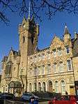

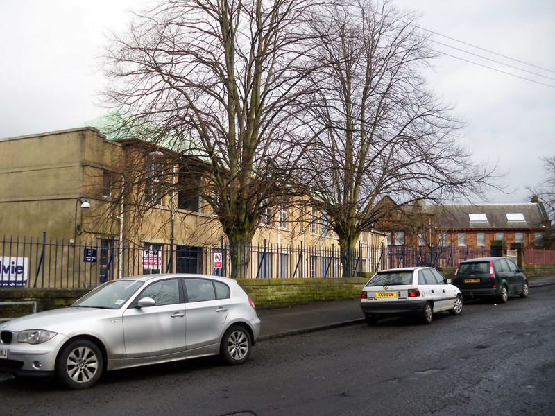
| Authority control |
|
|---|