Poospatuck Reservation
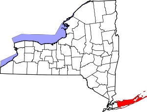
The Poospatuck Reservation is an Indian reservation of the Unkechaugi band in the community of Mastic, Suffolk County, New York, United States. It is one of two Native American reservations in Suffolk County, the other being the Shinnecock Reservation. The population was 271 at the 2000 census.
Poospatuck Reservation, New York | |
|---|---|
Reservation | |
 | |
 Poospatuck Reservation, New York | |
| Coordinates: 40°47′23″N 72°49′58″W | |
| Country | United States |
| State | New York |
| County | Suffolk |
| Area | |
| • Land | 0.1130 sq mi (0.2927 km2) |
| • Water | 0.0562 sq mi (0.1456 km2) |
| Elevation | 17 ft (5 m) |
| Population (2000) | |
| • Total | 271 |
| • Density | 3,040.9/sq mi (1,162.6/km2) |
| Time zone | UTC-5 (Eastern (EST)) |
| • Summer (DST) | UTC-4 (EDT) |
| ZIP code | 11950 |
| Area code(s) | 631 |
| GNIS feature ID | 979384 |
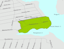
The Unkechaugi are descendants of the Pequot people, who occupied much of southern New England and eastern Long Island at the time of European encounter in the colonial era. Historically they spoke an Algonquian language. They have retained a community; the reservation is the smallest in New York State. It is located in Mastic on the north side of Poospatuck Creek, on the east side of Poospatuck Lane, and south of Eleanor Avenue. Poospatuck is situated in the southeast corner of Suffolk County's present-day Town of Brookhaven; and is the township's sole Indian reservation. It is about 70 miles or 1½ hours east of New York City.
The reservation and its people are recognized as Native American by the state of New York but it has not received federal recognition from the US Bureau of Indian Affairs. This means that it does not control sovereign territory and may not conduct Indian gaming on its land.
Geography
According to the United States Census Bureau, the Indian reservation has a land area of 72.3 acres (0.293 km2), and a water area of 36 acres (0.15 km2). The reservation reports the size of the reservation is actually 55 acres (0.22 km2).[1]
Demographics
| Historical population | |||
|---|---|---|---|
| Census | Pop. | %± | |
| 1970 | 125 | — | |
| 1980 | 203 | 62.4% | |
| 1990 | 136 | −33.0% | |
| 2000 | 271 | 99.3% | |
| 2010 | 324 | 19.6% | |
| Est. 2014 | 326 | [2] | 0.6% |
| U.S. Decennial Census[3] | |||
As of the census of 2000, there were 271 people, 93 households, and 67 families residing in the Indian reservation. The population density was 3,040.9/mi2 (1,162.6/km2). There were 100 housing units at an average density of 1,122.1 inhabitants/mi2 (429.0 inhabitants/km2). The racial makeup of the Indian reservation was 1.48% White, 12.92% African American, 79.34% Native American (mostly Unkechaug people), no Asians, no Pacific Islanders, 0.74% from other races, and 5.54% from two or more races. 4.80% of the population were Hispanic or Latino of any race.
There were 93 households out of which 47.3% had children under the age of 18 living with them, 29.0% were married couples living together, 32.3% had a woman whose husband does not live with her, and 26.9% were non-families. 24.7% of all households were made up of individuals and 2.2% had someone living alone who was 65 years of age or older. The average household size was 2.91 and the average family size was 3.51.
In the Indian reservation the population was spread out with 36.5% under the age of 18, 10.0% from 18 to 24, 30.3% from 25 to 44, 17.3% from 45 to 64, and 5.9% who were 65 years of age or older. The median age was 27 years. For every 100 females, there were 78.3 males. For every 100 females age 18 and over, there were 79.2 males.
The median income for a household in the Indian reservation was $13,125, and the median income for a family was $17,500. Males had a median income of $47,500 versus $20,250 for females. The per capita income for the Indian reservation was $8,127. 36.6% of the population and 36.8% of families were below the poverty line. Out of the total people living in poverty, 46.6% were under the age of 18 and 25.0% were 65 or older.
References
- Newsday.com
- "Annual Estimates of the Resident Population for Incorporated Places: April 1, 2010 to July 1, 2014". Archived from the original on May 23, 2015. Retrieved June 4, 2015.
- "Census of Population and Housing". Census.gov. Retrieved June 4, 2015.
- Poospatuck (state) Reservation, New York United States Census Bureau