Brightwaters, New York
Brightwaters is an upscale village in the southwest part of the Town of Islip in Suffolk County, New York, United States. The population was 3,103 at the time of the 2010 census.[3]
Brightwaters, New York | |
|---|---|
Village | |
| Village of Brightwaters | |
 | |
 Brightwaters, New York Location within the state of New York | |
| Coordinates: 40°43′17″N 73°15′57″W | |
| Country | United States |
| State | New York |
| County | Suffolk |
| Incorporated | November 30, 1916[1] |
| Area | |
| • Total | 1.0 sq mi (2.6 km2) |
| • Land | 1.0 sq mi (2.5 km2) |
| • Water | 0.04 sq mi (0.1 km2) |
| Elevation | 23 ft (7 m) |
| Population (2010) | |
| • Total | 3,103 |
| • Estimate (2018)[2] | 3,054 |
| • Density | 3,100/sq mi (1,200/km2) |
| Time zone | UTC-5 (Eastern (EST)) |
| • Summer (DST) | UTC-4 (EDT) |
| ZIP code | 11718 |
| Area code(s) | 631 |
| FIPS code | 36-08323 |
| GNIS feature ID | 0975774 |
| Website | www |
Geography
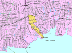
Brightwaters is located at 40°43′17″N 73°15′57″W (40.721442, -73.265869).[4] It contains Wohseepee Park in northern Brightwaters, the Brightwaters Canal directly south of Montauk Highway, and four lakes directly north of Montauk Highway: Cascades Lake, Mirror Lake, Lagoon Lake and Nosrekca Lake. The village businesses are located at the intersection of Windsor Avenue and Orinoco Drive (referred to as Brightwaters Village). These geographic features make up the three districts of the village; the Canal District (southern Brightwaters, everything south of Montauk Highway), the Lakes District (central Brightwaters, everything north of the highway to Union Boulevard) and the Wohseepee Park District (northern Brightwaters, everything north of Union Boulevard to Seneca Drive).
According to the United States Census Bureau, the village has a total area of 1.0 square mile (2.6 km2), of which 0.97 square miles (2.5 km2) is land and 0.04 square miles (0.1 km2), or 2.26%, is water.[3]
Brightwaters residents are served by the Bay Shore School District, and have a ZIP code (11718) that is distinct from the Bay Shore Postal District (11706).
Demographics
| Historical population | |||
|---|---|---|---|
| Census | Pop. | %± | |
| 1920 | 250 | — | |
| 1930 | 1,061 | 324.4% | |
| 1940 | 1,562 | 47.2% | |
| 1950 | 2,336 | 49.6% | |
| 1960 | 3,193 | 36.7% | |
| 1970 | 3,808 | 19.3% | |
| 1980 | 3,286 | −13.7% | |
| 1990 | 3,265 | −0.6% | |
| 2000 | 3,248 | −0.5% | |
| 2010 | 3,103 | −4.5% | |
| Est. 2018 | 3,054 | [2] | −1.6% |
| U.S. Decennial Census[5] | |||
At the 2000 census there were 3,248 people, 1,127 households, and 912 families in the village. The population density was 3,299.2 people per square mile (1,279.7/km²). There were 1,144 housing units at an average density of 1,162.0 per square mile (450.7/km²). The racial makeup of the village was 95.23% White, 1.57% African American, 0.06% Native American, 1.29% Asian, 0.06% Pacific Islander, 0.65% from other races, and 1.14% from two or more races. Hispanic or Latino of any race were 4.06%.[6]
Of the 1,127 households 38.9% had children under the age of 18 living with them, 71.8% were married couples living together, 6.8% had a female householder with no husband present, and 19.0% were non-families. 14.6% of households were one person and 5.9% were one person aged 65 or older. The average household size was 2.87 and the average family hi size was 3.20.
The age distribution was 27.3% under the age of 18, 5.0% from 18 to 24, 28.8% from 25 to 44, 27.2% from 45 to 64, and 11.7% 65 or older. The median age was 38 years. For every 100 females, there were 93.7 males. For every 100 females age 18 and over, there were 94.7 males.
The median household income was $146,892 and the median family income was $121,569 About 0.8% of families and 1.8% of the population were below the poverty line, including 0.7% of those under age 18 and none of those age 65 or over.
Notable people
- Rick Lazio, congressman, 2000 Senatorial candidate, and former gubernatorial candidate (R)
References
- http://www.villageofbrightwaters.com/about-brightwaters
- "Population and Housing Unit Estimates". Retrieved November 21, 2019.
- "Geographic Identifiers: 2010 Demographic Profile Data (G001): Brightwaters village, New York". U.S. Census Bureau, American Factfinder. Archived from the original on February 12, 2020. Retrieved December 20, 2012.
- "US Gazetteer files: 2010, 2000, and 1990". United States Census Bureau. 2011-02-12. Retrieved 2011-04-23.
- "Census of Population and Housing". Census.gov. Retrieved June 4, 2015.
- "U.S. Census website". United States Census Bureau. Retrieved 2008-01-31.
External links
| Authority control |
|
|---|