Nissequogue, New York
Nissequogue (/ˈnɪsəkwɒɡ/)[3] is a village in Suffolk County, New York, United States, on the North Shore of Long Island. As of the 2010 census, the village population was 1,749.[4]
Nissequogue, New York | |
|---|---|
Village | |
| Village of Nissequogue | |
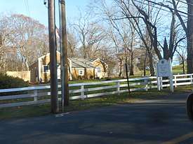 Village Hall and Police Station as seen in November 2019. | |
 U.S. Census Map | |
 Location within the state of New York | |
| Coordinates: 40°53′55″N 73°11′41″W | |
| Country | United States |
| State | New York |
| County | Suffolk |
| Incorporated | 1926 |
| Area | |
| • Total | 4.0 sq mi (10.3 km2) |
| • Land | 3.8 sq mi (9.8 km2) |
| • Water | 0.2 sq mi (0.5 km2) |
| Elevation | 85 ft (26 m) |
| Population | |
| • Total | 1,749 |
| • Estimate (2018)[2] | 1,733 |
| • Density | 440/sq mi (170/km2) |
| Time zone | UTC-5 (Eastern (EST)) |
| • Summer (DST) | UTC-4 (EDT) |
| ZIP code | 11780 |
| Area code(s) | 631 |
| FIPS code | 36-51286 |
| GNIS feature ID | 0958622 |
| Website | nissequogueny |
The village of Nissequogue is located in the town of Smithtown. It is within the postal boundaries of the St. James, New York, but it is not part of St. James. It became an incorporated village in 1926.[5]
The current mayor of the village is a descendant and a namesake of the first English settler of the village, Richard Smith (Smythe).
Geography
According to the United States Census Bureau, the village has a total area of 4.0 square miles (10 km2), of which 3.8 square miles (9.8 km2) is land and 0.2 square miles (0.52 km2), or 5.04%, is water.
To the west of the village is its namesake, the Nissequogue River. To the north is Long Island Sound, while to the east is Stony Brook Harbor. Moriches Road runs through the center of the village.
Main Attractions
Nissequogue is known for its preservation of the natural Long Island landscape. Its unique scenery is facilitated by a 2 acre minimum on property divisions and a ban on industry real estate throughout the village's boundaries.[6][7]
The Saint James General Store is a famous historical building, part of the Saint James District. Nissequogue's most popular parks are Long Beach Town Park, Short Beach, and The David Weld Sanctuary.

Demographics
| Historical population | |||
|---|---|---|---|
| Census | Pop. | %± | |
| 1930 | 174 | — | |
| 1940 | 188 | 8.0% | |
| 1950 | 219 | 16.5% | |
| 1960 | 332 | 51.6% | |
| 1970 | 1,120 | 237.3% | |
| 1980 | 1,462 | 30.5% | |
| 1990 | 1,620 | 10.8% | |
| 2000 | 1,543 | −4.8% | |
| 2010 | 1,749 | 13.4% | |
| Est. 2018 | 1,733 | [2] | −0.9% |
| U.S. Decennial Census[8] | |||
As of the census of 2000, there were 1,543 people, 533 households, and 455 families residing in the village. The population density was 408.9 people per square mile (158.0/km²). There were 570 housing units at an average density of 151.1 per square mile (58.4/km²). The racial makeup of the village was 97.34% White, 0.13% African American, 0.97% Asian, and 1.56% from two or more races. Hispanic or Latino of any race were 2.92% of the population.[1]
There were 533 households out of which 36.0% had children under the age of 18 living with them, 79.2% were married couples living together, 4.5% had a female householder with no husband present, and 14.6% were non-families. 12.2% of all households were made up of individuals and 4.3% had someone living alone who was 65 years of age or older. The average household size was 2.89 and the average family size was 3.15.[1]
In the village, the population was spread out with 25.6% under the age of 18, 4.4% from 18 to 24, 25.3% from 25 to 44, 32.9% from 45 to 64, and 11.9% who were 65 years of age or older. The median age was 42 years. For every 100 females, there were 106.0 males. For every 100 females age 18 and over, there were 100.7 males.[1]
The median income for a household in the village was $140,786, and the median income for a family was $157,973. Males had a median income of $100,000 versus $69,167 for females. The per capita income for the village was $63,148. About 1.1% of families and 2.4% of the population were below the poverty line, including none of those under age 18 and 2.7% of those age 65 or over.[1]
References
- "U.S. Census website". United States Census Bureau. Retrieved 2008-01-31.
- "Population and Housing Unit Estimates". Retrieved January 3, 2020.
- http://www.forvo.com/search/Nissequogue/
- "Population in the U.S. -Google Public Data Explorer". U.S. Census Bureau. Retrieved May 29, 2019.
- "Village of Nissequogue". Suffolk County Village Officials Association. Retrieved August 23, 2010.
- "Village of Nissequogue, NY: Size and area requirements". Village of Nissequogue, NY Code. Retrieved 2019-05-29.
- "Village of Nissequogue, NY: Limitations". Village of Nissequogue, NY Code. Retrieved 2019-05-29.
- "Census of Population and Housing". Census.gov. Retrieved June 4, 2015.
External links
![]()
| Authority control |
|
|---|