Onondaga Reservation
Onondaga Reservation is an Indian reservation in Onondaga County, New York, United States. It is the territory of the Onondaga Nation. It lies just south of the city of Syracuse. The population was 468 at the 2010 census.
Onondaga Reservation | |
|---|---|
 Onondaga Reservation Location within the state of New York | |
| Coordinates: 42°56′31″N 76°9′21″W | |
| Country | United States |
| State | New York |
| Counties | Onondaga |
| Area | |
| • Total | 9.3 sq mi (24.1 km2) |
| • Land | 9.3 sq mi (24.0 km2) |
| • Water | 0.04 sq mi (0.1 km2) |
| Population (2010) | |
| • Total | 2,244 |
| • Density | 240/sq mi (93/km2) |
| Time zone | UTC-5 (Eastern (EST)) |
| • Summer (DST) | UTC-4 (EDT) |
| Area code(s) | 315 |
| Website | http://www.onondaganation.org/ |
The Onondaga Reservation is a politically independent entity, as the nation is federally recognized by the United States government. The Onondaga Nation has reached some accommodations with New York State on jurisdictional issues.
Geography
According to the United States Census Bureau, the Indian reservation has a total area of 9.3 mi² (24.1 km²). 9.2 mi² (24.0 km²) of it is land and 0.1 square miles (0.26 km2) of it (0.54%) is water.[1]
New York State Route 11A is a north–south highway in the reservation. The reservation is bordered by the Town of Onondaga and the Town of LaFayette.
Demographics
| Historical population | |||
|---|---|---|---|
| Census | Pop. | %± | |
| 1900 | 530 | — | |
| 1910 | 565 | 6.6% | |
| 1920 | 475 | −15.9% | |
| 1930 | 611 | 28.6% | |
| 1940 | 762 | 24.7% | |
| 1950 | 894 | 17.3% | |
| 1960 | 941 | 5.3% | |
| 1970 | 785 | −16.6% | |
| 1980 | 596 | −24.1% | |
| 1990 | 771 | 29.4% | |
| 2000 | 1,473 | 91.1% | |
| 2010 | 468 | −68.2% | |
| Est. 2014 | 473 | [2] | 1.1% |
| U.S. Decennial Census[3] | |||
At the 2000 census there were 1,473 people, 304 households, and 292 families residing in the Indian reservation. The population density was 159.2/mi² (61.5/km²). There were 311 housing units at an average density of 33.6/mi² (13.0/km²). The racial makeup of the Indian reservation was 51.80% Native American, 42.84% White, 1.70% Black or African American, 0.20% Pacific Islander, and 3.46% from two or more races. Hispanic or Latino of any race were 0.34%.[4]
Of the 304 households 85.2% had children under the age of 18 living with them, 57.9% were married couples living together, 15.8% had a female householder with no husband present, and 3.9% were non-families. 1.6% of households were one person and 0.3% were one person aged 65 or older. The average household size was 4.85 and the average family size was 4.67.
In the Indian reservation the population was spread out with 50.2% under the age of 18, 6.6% from 18 to 24, 28.0% from 25 to 44, 11.7% from 45 to 64, and 3.5% 65 or older. The median age was 18 years. For every 100 females, there were 108.6 males. For every 100 females age 18 and over, there were 118.5 males.
The median household income was $65,655 and the median family income was $57,250. Males had a median income of $44,688 versus $28,750 for females. The per capita income for the Indian reservation was $15,425. About 8.6% of families and 7.6% of the population were below the poverty line, including 8.6% of those under age 18 and 4.4% of those age 65 or over.[5]
External links
References
- "US Gazetteer files: 2010, 2000, and 1990". United States Census Bureau. 2011-02-12. Retrieved 2011-04-23.
- "Annual Estimates of the Resident Population for Incorporated Places: April 1, 2010 to July 1, 2014". Archived from the original on May 23, 2015. Retrieved June 4, 2015.
- "Census of Population and Housing". Census.gov. Retrieved June 4, 2015.
- "U.S. Census website". United States Census Bureau. Retrieved 2008-01-31.
- The U.S. Census Bureau conducts census data collection as part of a unique government to government trust relationship and will consult with the tribal government before making any policy or planning decisions. "American Indian and Alaska Native Policy of the U.S. Census Bureau" (PDF). U.S. Census Bureau.
Municipalities and communities of Onondaga County, New York, United States | ||
|---|---|---|
| City | 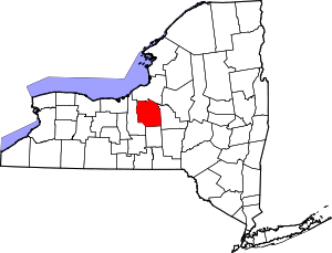 | |
| Towns | ||
| Villages | ||
| CDPs | ||
| Other hamlets |
| |
| Indian reservation | ||
| Footnotes | ‡This populated place also has portions in an adjacent county or counties | |
| Authority control |
|
|---|