Plumpton, East Sussex
Plumpton is a village and civil parish in the Lewes District of East Sussex, England. The village is located five miles (8 km) north-west of Lewes. The parish measures 6.5 miles in length on its north–south axis and 1 mile at its widest on the B2116 Underhill Road. The southern half of the parish lies within the South Downs National Park and at the highest point, 214m (702 feet), the South Downs Way traverses the crest of Plumpton Plain. The parish includes the small village of Plumpton adjacent to the Downs and to the north the larger village of Plumpton Green where most of the community and services are based. Plumpton is probably best known for its race course, and also Plumpton College, which farms over 2500 acres of land and has become one of the leading centres for land-based education in the UK.
| Plumpton | |
|---|---|
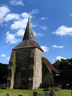 Church of St Michael, Plumpton | |
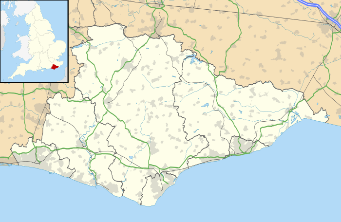 Plumpton Location within East Sussex | |
| Area | 9.7 km2 (3.7 sq mi) [1] |
| Population | 1,644 (Parish-2011)[2] |
| • Density | 450/sq mi (170/km2) |
| OS grid reference | TQ359132 |
| • London | 41 miles (66 km) N |
| District |
|
| Shire county | |
| Region | |
| Country | England |
| Sovereign state | United Kingdom |
| Post town | LEWES |
| Postcode district | BN7 |
| Dialling code | 01273 |
| Police | Sussex |
| Fire | East Sussex |
| Ambulance | South East Coast |
| UK Parliament | |
| Website | Plumpton Council |
Plumpton is mentioned in the Domesday Book of 1086 as having a church and two mills, and is shown as Pluntune, meaning 'town or settlement where plum-trees grew'.[3]
Village layout
Plumpton Green is essentially a ribbon development immediately to the north of the railway station and is home to the school, the village shop, a church and two pubs. The main thoroughfare, Station Road, runs the length of the village, with several cul-de-sacs branching from it. The majority of the road is paved on one side only.
Chapel Road is a cul-de-sac with 24 houses. These are mostly semi-detached, with a small terrace of cottages built in 1900. Woodgate Meadow is a fairly recent development of large, detached houses on the site of a former brickyard. Westgate was built on farmland some years later (1995) incorporating mainly detached houses and also the new village hall and green.
Plumpton Lane, connecting Plumpton and Plumpton Green has, in recent years, received several small housing developments. The houses are of an attractive design, incorporating traditional red Sussex tile-hung walls.
Plumpton railway station is on the East Coastway Line and the railway crossing had the last manually operated gates in Sussex, until finally replaced by automatic gates in 2016. As of December 2010 it has had an hourly service in each direction, between Eastbourne, Hastings and Ore and London Victoria. Plumpton Racecourse is located between the two villages, immediately to the south of the railway. Meetings draw large crowds and on race days the population of Plumpton doubles and the rail service is supplemented with extra trains. Races are sometimes televised, bringing Plumpton to a much wider audience.
In the early 1970s, Led Zeppelin guitarist Jimmy Page purchased Plumpton Place, an Elizabethan manor, with 20th-century alterations by Sir Edwin Lutyens, surrounded by a moat and extensive gardens. With its relative proximity to Plumpton Racecourse the grounds also include stables for horses. Page outfitted the manor with a recording studio and the credits for the Led Zeppelin album In Through the Out Door indicates that album mixing was carried out there. The manor can be seen briefly near the beginning of the Led Zeppelin concert film, The Song Remains the Same where the camera walks up to Page, playing a hurdy-gurdy, to inform him of the North American tour dates. Page sold the property in 1985.
Village groups
There are many groups and societies in comparison to the size of the village; one of the most notable being Plumpton Players, a drama group. The society performs up to two plays a year. In 2007, the society was chosen to perform the worldwide premiere of A Wet and Windy Night by Declan Cleary. In May 2008, the Players performed Dave Freeman's classic comedy/farce A Bedful of Foreigners. In May 2009, the players performed another first. Don't Look Now by Daphne du Maurier, adapted for the stage by Nell Leyshon, was a real departure for the group and proved that they were as good at disturbing serious productions as well as comedies and farces. The Players presented another "first" in May 2010 when they become the first amateur group to tackle Richard Bean's Political Sex Farce, In the Club. In May 2013 two one-act plays by David Tristram, Last Tango in Plumpton and Brenton versus Brenton kept the audience entertained. Their production, Drowning on Dry Land by Alan Ayckbourn maintained the very high standards that we have come to expect of this group. In May, to celebrate their 20th year, Plumpton Players presented Habeas Corpus by Alan Bennett. The village also has a Pantomime Society; every year they put on a different show.
There are also sporting groups, which attract visitors from across Sussex, including cricket, tennis, rugby and football clubs. The rugby club plays in Sussex Division 1. The cricket club is one of the most successful village teams in the area consistently winning both the Mid Sussex League and the Wisdom Cup. The club was the first in the area to wear "Coloured Clothing" in their cup matches. The kit consisted of maroon and yellow trousers with matching shirts. In 2008 the team moved to the East Sussex League winning the league by nearly 100 points. The season was a double success as the 2nd eleven also won their division by nearly 80 points. In 2009, the first eleven completed their second successive league win and promotion by winning division 3 by over 80 points, recording 14 wins and being the only team in all 12 divisions to stay unbeaten throughout the season. In 2013 the 1st xl had their best ever finish 4th in div1 and the 2nds were promoted to div 6.
Governance
Plumpton is part of the electoral ward called Plumpton, Streat, East Chiltington and St John (Without). The population of this ward at the 2011 census was 2,276.[4]
Education
Plumpton Primary School.[5] is located in Plumpton Green and was built in 1974 for children living in Plumpton and surrounding villages, especially Wivelsfield, Hamsey, and Chailey. The school has an assembly hall, a student library, a playing field and a (now defunct) swimming pool.
Schooling began in 1837,[6] where two teachers taught in a small building (measuring 22×16' – 6.7×4.9m ) in the south of the parish in Plumpton village. This was the main centre of the parish population, which was then around 275, with some 20 children attending school. With the completion of the railway in 1846 and the opening of the station in 1863, two miles to the north, the centre of the parish gradually moved towards it. By the 1870s there were three drinking establishments, the village shop and a few other small businesses to the north of the station, spaced along Station Road. There were also a number of brickmaking sites in the open fields to either side of the road. The 1870 Education Act introduced compulsory education and during 1875 the newly formed Plumpton School Board approached a total of six local landowners to sell a half-acre plot for the building of the school. All refused. The threat of compulsory purchase finally procured, for £250, a corner of a meadow bordered by a stream 200m north of the railway and in 1877 building commenced on a large single schoolroom, surmounted by a prominent bell-tower, with adjoining three-bedroomed house for the schoolmaster. The parish population was about 400 at this time; the school was designed for 64 pupils, and opened in 1878. During the first few years absenteeism was very high as it was common for children to work from an early age.
Apart from brick-making and farming there were other rural activities such as bird-scaring, hare-coursing, acorn-picking, horse-driving, steeplechasing; even collecting flowers for the May Day celebrations. The school functioned for almost a century, and was extended at least twice to accommodate the ever-increasing population. It was eventually superseded by the present school, which was built in 1974 at the end of Southdowns cul-de-sac, and provides education facilities for 150 pupils, ranging from the ages of 4 to 11 in seven educational years. The redundant old school building had a number of community uses and then became a private residence until, in the late 1980s, with the addition of three new cottages it was converted into a total of seven dwellings. The school bell, still intact in the tower, was presented to the new school, where it is prominently displayed in the courtyard. The adjoining schoolhouse was unaffected by this development, and remained unchanged.
Landmarks
The Clayton to Offham Escarpment is a Site of Special Scientific Interest along the ridge and slopes of the South Downs. Stretching some 10 km from Hassocks in the west to Lewes in the east, it passes through several parishes including Plumpton. The site is of biological importance due to its rare chalk grassland habitat along with its woodland and scrub.[7]
On the Downs in the south of the parish, there is evidence of ancient settlements, with enclosures and tumuli. There are also signs of the conflict in which Simon de Montfort fought and defeated Henry III at the Battle of Lewes in 1264. He gained complete surprise and a strategic advantage by using a night march to position his numerically inferior army on downland high above the town early in the morning. To avoid detection they ascended the Downs four miles to the north-west of Lewes up Warningore Bostal, a deeply-worn track that exists to this day. Before marching on the town de Montfort is reputed to have rallied his forces, wearing large white crosses on their tunics for identification, on Plumpton Plain. At the highest point of this wide expanse the nearby north scarp of the Downs has a 100-foot cross carved into the chalk, possibly by monks from St Pancras' Priory in Lewes. The cross is no longer white as the chalk has long been overgrown, but to the knowledgeable eye it is still visible due to its lighter-coloured grass. It can also be seen from a distance of several miles when the sun is low and the depression is in shadow.[8] Although now no longer in place, within living memory a sandstone block at the centre of the cross bore the inscription 'Battle of Lewes 1264'.
The most visible boundary of the South Downs National Park aligns with the southernmost access road to Plumpton Racecourse, which itself runs alongside the Sussex Greensand Way, the Roman Road that crossed the parish in an east–west direction.
Notable people
- Edward James Boys (1916-2002), historian of the Crimean War was born here
In popular culture
Plumpton Green is rumoured to have been the inspiration for the popular 1960s British children's television series Trumpton by Gordon Murray, with nearby Chailey being Chigley and Wivelsfield Green being Camberwick Green.[9]
References
- "East Sussex in Figures". East Sussex County Council. Retrieved 26 April 2008.
- "Civil parish population 2011". Retrieved 12 October 2015.
- Eilert Ekwall, The Concise Oxford Dictionary of English Place-names, p.369.
- "Plumpton, Streat, East Chiltington and St John (Without) ward 2011". Retrieved 12 October 2015.
- "Website Main Page". Plumpton Primary School. Retrieved 3 January 2009.
- "Plumpton School History". Plumpton Primary School. Archived from the original on 7 February 2006. Retrieved 3 January 2009.
- "Natural England – SSSI (Clayton to Offham Escarpment)". English Nature. Retrieved 5 October 2008.
- Hows, Mark. "Ditchling Cross". Hill Figures Website. Retrieved 19 April 2009.
- "In Search of the Real Trumptonshire". Trumptonshire Web. Retrieved 19 April 2009.