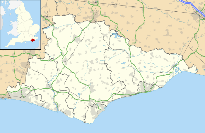
Southease
Southease is a small village and civil parish in East Sussex, in South East England between the A26 road and the C7 road from Lewes to Newhaven. The village is to the west of the River Ouse, Sussex and has a church dedicated to Saint Peter. Southease railway station lies roughly a kilometre east over the river and may be reached via a swing bridge.
| Southease | |
|---|---|
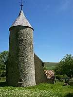
 Southease church | |
 Southease Location within East Sussex | |
| Area | 11.26 km2 (4.35 sq mi) -Rodmell & Southease[1] |
| Population | 502 (2007)[1] |
| • Density | 115.5/sq mi (44.6/km2) |
| OS grid reference | TQ421053 |
| • London | 47 miles (76 km) N |
| District | |
| Shire county | |
| Region | |
| Country | England |
| Sovereign state | United Kingdom |
| Post town | LEWES |
| Postcode district | BN7 |
| Dialling code | 01273 |
| Police | Sussex |
| Fire | East Sussex |
| Ambulance | South East Coast |
| UK Parliament | |
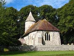
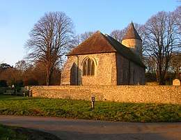
The church has one of only three round towers in Sussex, all of which are located in the Ouse Valley and all three built in the first half of the 12th century.
It is downstream of Lewes, the county town of East Sussex and upstream of Piddinghoe and Newhaven. Paths along both the banks of the river allow hiking in either direction along the river. The remains of a slipway on the west bank of the Ouse just north of the bridge faces Mount Caburn. The nearest village is Rodmell, about a kilometre to the northwest.
The South Downs Way winds its way through the village towards the nearby River Ouse and the railway station. A new bridge has been built over the A26.[2]
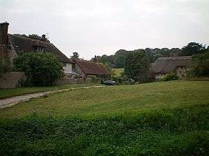
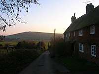
Most cottages in the village date from the 17th century.[3]
The population of the village is about forty.
History
Name
The name seems to be of Anglo-Saxon origin, meaning "South land overgrown with brushwood".[4]
Historical record
The village first appears in the historical record when King Edgar granted the manor of Southease (including Southease parish, 38 hides, a church and part of South Heighton) to Hyde Abbey.[4] It was granted to the abbey again by King Æthelred in 996.[3] The church dates from the year 966.[5]
At the time of the Domesday Book a thriving community was in place and the village appears to have been the biggest herring fishery in the district, having been assessed for 38,500 herring while Brighton had a mere 4,000.[4]
Village history is closely linked with the Ouse and Lewes Levels.[4] In the 11th to 13th centuries drainage of the river allowed more crops to be grown, but subsequent flooding led to more relying on fishing.[4]
After the Dissolution of the Monasteries, the manor probably remained in possession of the King and in 1546 one John Kerne was appointed bailiff and collector of the manors of Southease, Telscombe and Heighton.[3] There was never a manor house in Southease as it was always owned by absentee landlords.[5]
The manor passed to the Sackville family – it was held by Thomas Sackville, his widow Cicely and their grandson Robert.[3]
The Lower Ouse Improvement Act of 1791 required the ferry to be replaced with a bridge substantial enough to allow cattle, people and vehicles to pass over while allowing ships to pass.[4] The original bridge was a wooden cantilever bridge slightly to the north of the current one.[4] The wooden bridge was demolished in 1879 when it was replaced by the current one.[4]
The population of the parish declined through the 19th century.[6] The census recorded a population of 120 in 1841 with the population falling with each census to 66 in 1891.[6]
The village was part of the Holmstrow hundred until the abolition of hundreds in the 19th century.[7]
During World War II four Type 24 pillboxes were built, roughly at the corners of the village, with a Type 28 pillbox just to the north.[4] The former were for rifles and light machine guns and the latter was for a 2-pounder anti-tank gun or a 6-pounder Hotchkiss gun.[4] There was also a Prisoner-of-war camp containing 16 Nissen huts near the northern farm, the concrete bases of which are still visible.[4] There was also an anti-aircraft gun.[4]
The body of the writer Virginia Woolf was found on 18 April 1941, at Asham Wharf on the east bank of the Ouse, to the north of the bridge, after her suicide by drowning on March 28.[8]
The church bells were rehung in 2000.[5]
Itford Farm, between the railway and A26, became a Youth Hostel in 2013.[9][10]
Listed buildings
Parish Church[11]
.jpg)
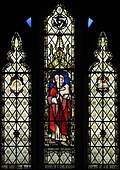
This is one of three churches in the Ouse valley to have a round 12th century tower - the others are in Lewes and Piddinghoe.[4] The chancel and nave date from the 11th century and form the nave of the original building, the chancel and transepts having being demolished in the 14th century.[4] There are remains of mural paintings from 1280 on the north and west walls.[4] It is a Grade I listed building.[4] The churchyard is surrounded by mature lime trees and bounded by a flint boundary wall.[4]
Southease Place[12]
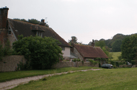
This is a 17th-century two-storey house with a tiled hipped roof.[4] The lower floor has been refaced with flints, the upper with stucco.[4] It is a Grade II listed building.[4]
Rock Cottage and Barn Cottage[13]
A former farmhouse that was divided into two cottages, this is probably 18th century, though Rock Cottage may be a later addition or have been refronted.[4] It is a Grade II listed building.[4]
Thatched Cottage[14]
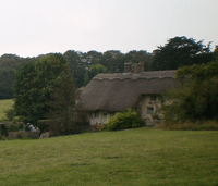
These are two separate cottages that were combined into a larger one.[4] It dates from the 18th century and has a thatched hipped roof.[4] It is a Grade II listed building.[4]
The Rectory[15]
This is an L-shaped building with a 16th-century frame that has been stuccoed and a 19th-century addition that has also been stuccoed.[4] A western gable bears the date 1604 and the monogram of John Rivers.[4] It is a Grade II listed building.[4]
Black Lamb House[16]
This is an 18th-century two storey house formerly known as "The Rest".[4] It is a Grade II listed building.[4]
Southease swing bridge[17]
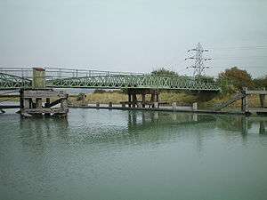
The bridge was built in the 1880s, is the second bridge on the site and though the swing mechanism remains, it has not been opened since 1967.[18] In September 2009 the bridge was granted Grade II listed building status.[19] The bridge was closed from 8 June to 26 November 2010 and a scaffold bridge was put in place for walkers and cyclists while the original bridge structure was lifted into the adjacent Environment Agency yard, restored and then replaced.[20][21] Other traffic had to take a detour for 10 kilometres (6.2 mi).[22] The wrought iron parts of the bridge were strengthened as it had suffered corrosion and twisting of the supports.[22] The turntable, deck and supporting timbers were replaced.[22]
Before bridges spanned the Ouse, the Stock Ferry, several hundred yards down stream of the current bridge, was the usual way of crossing.[3]
Transport
Southease railway station is on the Seaford branch line. Compass Travel runs the 123 bus which stops on the C7 road.[23][24]
Governance
On a local level, Southease parish is governed as a Parish Meeting with twice yearly meetings of the parish electorate.
The next level of government is the district council. The parish of Southease lies within the Kingston ward of Lewes District Council, which returns a single seat to the council. The election on 12 May 2015 elected a Liberal Democrat[25]
East Sussex County Council is the next tier of government, for which Southease is within the Newhaven and Ouse Valley West division, with responsibility for Education, Libraries, Social Services, Civil Registration, Trading Standards and Transport. Elections for the County Council are held every four years. The Liberal Democrat Carla Butler was elected in the 2013 election.[26]
The UK Parliament constituency for Southease is Lewes. The Liberal Democrat Norman Baker served as the constituency MP from 1997 until 2015, when Conservative Maria Caulfield was elected.
At European level, Southease is represented by the South-East region, which holds ten seats in the European Parliament. The June 2014 election returned 3 Conservatives, 1 Liberal Democrats, 4 UK Independence, 1 Labour and 1 Green, none of whom live in East Sussex.[27]
References
- "East Sussex in Figures". East Sussex County Council. Retrieved 26 April 2008.
- New Bridge over A26 near Southease
- Southease, A History of the County of Sussex: Volume 7, L. F. Salzman (editor), retrieved 15 May 2009
- "Southease Conservation Area Character Appraisal and Management Plan" (PDF). South Downs National Park Authority. July 2017. Retrieved 27 January 2020.
- Southease, Rodmell, Telscombe, Louise Schweitzer
- "Sussex Online Parish Clerks – Southease". Retrieved 25 June 2012.
- Parliamentary Papers, House of Commons and Command, Volume 11. H M Stationery Office. 1831.
- Newhaven to Lewes walk Archived 16 August 2009 at the Wayback Machine – mentions Asham Wharf
- "Historic South Downs farm converted to youth hostel". BBC News. 31 March 2013. Retrieved 7 May 2018.
- Calder, Simon (6 April 2013). "B&B and beyond: YHA South Downs, East Sussex". The Independent. Retrieved 7 May 2018.
- Historic England. "The Parish Church (Grade I) (1239384)". National Heritage List for England. Retrieved 9 February 2020.
- Historic England. "Southease Place (Grade II) (1239387)". National Heritage List for England. Retrieved 9 February 2020.
- Historic England. "Barn Cottage Rock Cottage (Grade II) (1239388)". National Heritage List for England. Retrieved 9 February 2020.
- Historic England. "Thatched Cottage (Grade II) (1239458)". National Heritage List for England. Retrieved 9 February 2020.
- Historic England. "The Rectory (Grade II) (1239461)". National Heritage List for England. Retrieved 9 February 2020.
- Historic England. "The Rest (Grade II) (1273728)". National Heritage List for England. Retrieved 9 February 2020.
- Historic England. "Swing Bridge over River Ouse (Grade II) (1393389)". National Heritage List for England. Retrieved 9 February 2020.
- Sussex Industrial Archaeology Society page with information on Southease Bridge and railway
- Historic swing bridge saved, Sussex Express, 17 September 2009, retrieved 21 September 2009
- Southease bridge to undergo refurbishment Archived 18 January 2010 at the Wayback Machine, , retrieved 22 January 2010
- Alan H.J. Green. "Southease Swing Bridge Reopens" (PDF). Sussex Industrial Archaeology Newsletter. Sussex Industrial Archaeology Society (149): 7–10.
- "Restored Southease Bridge officially opened". BBC News. 26 November 2010. Retrieved 12 June 2020.
- "Bus Services". Southease Village Website. Retrieved 7 May 2018.
- "123 - 24.07.17 123.pdf" (PDF). 24 July 2017. Retrieved 7 May 2018.
- "Election Results". Lewes District Council. 4 May 2007. Archived from the original on 18 September 2008. Retrieved 15 November 2008.
- "Councillor David Rogers OBE". Find your Councillor. East Sussex County Council. Retrieved 15 November 2008.
- "UK MEP's". UK Office of the European Parliament. Archived from the original on 17 September 2007. Retrieved 19 September 2007.
External links
| Wikimedia Commons has media related to Southease. |
- Southease village website
- Page of local attractions and a map
- Details about the church at Online Parish Clerks
- South Downs Way page section covering Southease
- Details of church architecture from Corpus of Romanesque Sculpture in Britain and Ireland
- Photos of Southease from geograph.org.uk