East Chiltington
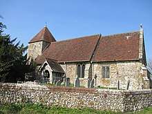
East Chiltington is a village and civil parish in the Lewes District of East Sussex, England. It is centred four miles (5.9 km) south-east of Burgess Hill and five miles (8 km) north-west of Lewes. It is a strip parish of 3.76 square miles (9.7 km2), stretching northward (south of Plumpton) from the crest of the South Downs. The village church is 13th century in origin; the vicar also has charge of two churches in Plumpton. Near the church a pub, The Jolly Sportsman stands beside a road upon the line of the Roman Sussex Greensand Way.
| East Chiltington | |
|---|---|
.jpg) Blackcap Hill | |
 East Chiltington Location within East Sussex | |
| Area | 9.75 km2 (3.76 sq mi) [1] |
| Population | 474 (Electors-2011)[2] |
| • Density | 61/sq mi (24/km2) |
| OS grid reference | TQ389148 |
| • London | 41 miles (66 km) N |
| Civil parish |
|
| District |
|
| Shire county | |
| Region | |
| Country | England |
| Sovereign state | United Kingdom |
| Post town | LEWES |
| Postcode district | BN7 |
| Dialling code | 01273 |
| Police | Sussex |
| Fire | East Sussex |
| Ambulance | South East Coast |
| UK Parliament | |
| Website | http://www.eastchiltington.net/ |
Governance
East Chiltington is governed at the local level by East Chiltington Parish Council which consists of seven councillors meeting every two months. The parish council represents the parish on matters governed at District and County level. The May 2015 election was contested by eight candidates.[3]
The next level of government is Lewes District Council. The District council supplies services such as refuse collection, planning consent, leisure amenities and council tax collection. East Chiltington is covered by the Plumpton, Streat, East Chiltington and St John (Without) ward which returns a single seat. In the May 2015 election, Sarah Osbourne, a councillor from the local Liberal Democrat party was elected.[4]
East Chiltington lies within the Chailey ward for the next tier of government, East Sussex County Council. The ward also includes Chailey, Ditchling, St John Without, Newick, Plumpton, Streat, Westmeston and Wivelsfield. The County Council provides services such as roads and transport, social services, libraries and trading standards. The county councilor is the Conservative Jim Sheppard.[5]
The UK Parliament constituency for East Chiltington is Lewes. The Conservative Maria Caulfield, a local nurse, has been serving as the constituency MP since 2015 when she defeated the incumbent Liberal Democrat Norman Baker
At European level, East Chiltington is represented by the South-East region, which holds ten seats in the European Parliament. The June 2004 election returned four Conservatives, two Liberal Democrats, two UK Independence, one Labour and one Green, none of whom live in East Sussex.[6]
Landmarks
Clayton to Offham Escarpment is a Site of Special Scientific Interest, which stretches from Hassocks in the west and passes through many parishes including East Chiltington, to Lewes in the east. The site is of biological importance due to its rare chalk grassland habitat along with its woodland and scrub.[7]
Blackcap is a 206 metres (676 ft) high hill that is part of the Clayton to Offham Escarpment, and lies within the parish. It forms part of the National Trust Blackcap nature reserve.[8]
References
| Wikimedia Commons has media related to East Chiltington. |
- "East Sussex in Figures". East Sussex County Council. Retrieved 26 April 2008.
- "Civil Parish Population 2011". Retrieved 12 October 2015.
- "Candidates - Town and Parish Council Elections" (PDF). Lewes District Council. 3 May 2007. Archived from the original (PDF) on 25 February 2009. Retrieved 7 June 2009.
- "Election Results: 4 May 2007". Lewes District Council. Archived from the original on 21 May 2009. Retrieved 7 June 2009.
- "Find your councillor". Lewes District Council. Retrieved 7 June 2009.
- "UK MEP's". UK Office of the European Parliament. Archived from the original on 24 January 2007. Retrieved 25 January 2007.
- "Natural England - SSSI (Clayton to Offham Escarpment)". English Nature. Archived from the original on 15 July 2009. Retrieved 5 October 2008.
- "Blackcap". Countryside Sites. Brighton & Hove City Council. Archived from the original on 31 July 2009. Retrieved 7 June 2009.