Ribbon development
Ribbon development is building houses along the routes of communications radiating from a human settlement. The resulting ribbons of development are clearly visible on land use maps and aerial photographs, giving cities and the countryside a particular character.[1] Such development generated great concern in the United Kingdom during the 1920s[2] and the 1930s as well as in numerous other countries.
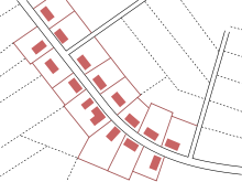
Normally the very first ribbons are focused on roads. Following the Industrial Revolution, ribbon development became prevalent along railway lines: predominantly in Russia, the United Kingdom, and the United States. However the cost of building stations, their attraction and need for accompanying roads usually led to new small urban centres and broader settlements. Ribbon development created great attractiveness on isolated roads as increasing motor car ownership meant that houses could be sold easily even if they were remote from workplaces and urban centres. It was attractive to developers because they did not have to waste money or plot space constructing roads. It also enabled spaces at the interstice between several urban areas appealing to potential buyers needing to access either or many of these.
The extent of the practice around roads led to its problems becoming intense and recognition as an inefficient use of resources, requiring bypass roads to be built, and often a precursor to untrammelled urban sprawl, so a key aim for the United Kingdom's post-war planning system was to implement a presumption and convention that proposed new ribbon development is inappropriate. Urban sprawl/suburbanisation of large areas led to the introduction of green belt policies, new towns, planned suburbs and garden cities.
History
Following the Industrial Revolution, ribbon development became prevalent along railway lines: predominantly in Russia, the United Kingdom, and the United States. A good example of this was the deliberate promotion of Metro-land[3][4] along London's Metropolitan Railway. Similar evidence can be found from Long Island (where Frederick W Dunton bought much real estate to encourage New Yorkers to settle along the Long Island Rail Road lines),[5] Boston[6] and across the American Midwest.[7][8][9]
It can also occur along ridge lines, canals and coastlines, the last occurring especially as people seeking seachange lifestyles build their houses where they can get the best view.
The resulting towns and cities are often difficult to service efficiently. Often, the first problems noticed by residents is traffic congestion, as people compete to move along the narrow urban corridor while ever more people join the ribbon further along the corridor. Urban consolidation is often a solution to encourage growth towards a more compact urban form.
Ribbon development can also be compared with a linear village, a village that grew along a transportation route, not as part of a city's expansion.
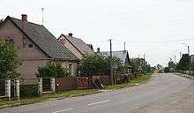
Ribbon development has long been viewed as an especial problem in the Republic of Ireland, where "one-off houses" proliferate on rural roads.[10] This causes difficulties in the efficient supply of water, sewerage, broadband, electricity, telephones and public transport.[11][12] In 1998, Frank McDonald contrasted development in the Republic with that in Northern Ireland: "Enniskillen [in Northern Ireland] is well defined with clear boundaries to the town and well-laid-out shopping streets. Letterkenny, [in the Republic] by contrast, appears as just one long street with bungalow development trailing off over all the surrounding hills."[13] The houses (ofter disparaged as "McMansions") are also criticised for spoiling countryside scenery: Monaghan County Council in 2013 declared that "The Council will resist development that would create or extend ribbon development."[14][15] Tipperary County Council and many other councils have adopted similar policies.[16]
See also
- Green belt
- Linear village
- One-off housing
References
- Caves, R. W. (2004). Encyclopedia of the City. Routledge. pp. 569. ISBN 9780415252256.
- "Trumpington Local History Group, Trumpington Timeline: 1901 - 1950". www.trumpingtonlocalhistorygroup.org.
- MetroLand Archived 2012-04-01 at the Wayback Machine. Easyweb.easynet.co.uk (1933-07-01). Retrieved on 2010-11-11.
- "Outer London and London beyond London - Drummond Robson makes the case for planning for town and country" (PDF). Archived from the original (PDF) on 2011-07-15.
- Long Island Railroad History Page - The Dunton Archive. Dunton.org. Retrieved on 2010-11-11.
- Railroads in the Midwest: Early Documents and Images (Knox College) : Home. Collections.carli.illinois.edu (1920-07-02). Retrieved on 2010-11-11.
- "The Railroads: Expansion and Economic Transformation in the Midwest - Dictionary definition of The Railroads: Expansion and Economic Transformation in the Midwest - Encyclopedia.com: FREE online dictionary". www.encyclopedia.com.
- Westward Expansion. Americanwest.com. Retrieved on 2010-11-11.
- Peillon, Michel; Corcoran, Mary P. (7 March 2018). Ireland Unbound: A Turn of the Century Chronicle. Institute of Public Administration. ISBN 9781902448695 – via Google Books.
- Day, Catharina (7 March 2018). Ireland. New Holland Publishers. ISBN 9781860113277 – via Google Books.
- "Housing limit to prevent 'ribbon development' on rural roadsides". Independent.ie. Retrieved 2019-12-04.
- O'Brien, Tim. "Ribbon development in rural housing criticised". The Irish Times. Retrieved 2019-12-04.
- Gourley, Toirleach (2015-12-03). "Ribbon Development, Exempt. Development and Other Issues" (PDF). Retrieved 2019-12-04.
- "Sustainable Rural Housing. Guidelines for Planning Authorities" (PDF). 2005-04-01. Retrieved 2019-12-04.
- "North Tipperary County Development Plan 2010-2016, CHAPTER 5 HOUSING" (PDF). Retrieved 2019-12-04.