Streat
Streat is a village in the Lewes district of East Sussex, England, 3 miles (4.8 km) south-east of Burgess Hill and 5 miles (8.0 km) west of Lewes, within the South Downs National Park.
| Streat | |
|---|---|
 Streat Place | |
 Streat Hill in the National Park | |
 Streat Location within East Sussex | |
| Area | 5.2 km2 (2.0 sq mi) [1] |
| Population | 158 (Parish-2011)[2] |
| • Density | 90/sq mi (35/km2) |
| OS grid reference | TQ351151 |
| • London | 40 miles (64 km) N |
| Civil parish |
|
| District |
|
| Shire county | |
| Region | |
| Country | England |
| Sovereign state | United Kingdom |
| Post town | HASSOCKS |
| Postcode district | BN6 |
| Police | Sussex |
| Fire | East Sussex |
| Ambulance | South East Coast |
| UK Parliament | |
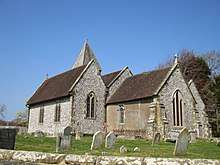
The 11th-century parish church has no dedication;[3] the ecclesiastical parish is joined with Westmeston.
Etymology
Anglo-Saxon place names containing "Street", "Streat" or "Stret" usually indicate a Roman road, and this is the case here, as Streat is built on the Sussex Greensand Way, and there is a north-south Roman or Romanised Celtic road known as the Middleton Track just over the west parish boundary border at Hayleigh Farm sweeping past Grade II listed Middleton Manor [4] which ascends the South Downs escarpment passing above the Victoria Jubilee Middleton Plantation.[5]
Landmarks
Clayton to Offham Escarpment is a Site of Special Scientific Interest, which stretches from Hassocks in the west and passes through many parishes including Streat, to Lewes in the east. The site is of biological importance due to its rare chalk grassland habitat along with its woodland and scrub.[6]
Old Rectory
There is an Old Rectory, a listed building, which may indicate the existence of chancel repair liability [7] to any lay improprietors of land which was once belonged to the church.
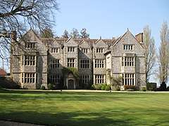
Streat Place
Streat Place is a manor house built in the early 17th century by Walter Dobell who died in 1624. The building has an E shaped plan with central porch and projecting wings.[8] Its national listing gives it as Grade II* and reveals its architectural merit as including its entire facing of knapped flints with long and short ashlar quoins to each window bay.[9]
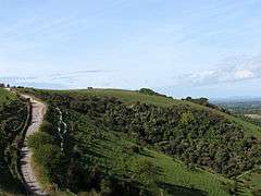
Streat Hill
The long north-south parish reaches its highest point in its southern quarter, here Streat Hill rises to 224m above sea level; here there are two earthworks or tumuli. These are two bowl barrows which are termed by archaeologists the Western Brow round barrow cemetery.[10]
Nearest Settlements | |
|---|---|
References
- "East Sussex in Figures". East Sussex County Council. Retrieved 26 April 2008.
- "Civil Parish population 2011". Retrieved 12 October 2015.
- Historic England. "Details from listed building database (1239635)". National Heritage List for England. Retrieved 16 June 2012. Architectural details
- Historic England. "Details from listed building database (1222783)". National Heritage List for England. Retrieved 16 June 2012. Middleton Manor
- Helen Livingston, In the Footsteps of Caesar: Walking Roman Roads in Britain 1995 BCA pp30-32
- "Natural England - SSSI (Clayton to Offham Escarpment)". English Nature. Retrieved 11 October 2008.
- Historic England. "Details from listed building database (1239655)". National Heritage List for England. Retrieved 16 June 2012. The Old Rectory
- http://www.british-history.ac.uk/report.aspx?compid=56931 Victoria County History A History of the County of Sussex: Volume 7
- Historic England. "Details from listed building database (1239638)". National Heritage List for England. Retrieved 16 June 2012. Streat Place
- Historic England. "Details from listed building database (1014625)". National Heritage List for England. Retrieved 16 June 2012. bowl barrow Historic England. "Details from listed building database (1014641)". National Heritage List for England. Retrieved 16 June 2012. Scheduled Ancient Monuments - bowl barrow