Phanna Nikhom District
Phanna Nikhom (Thai: พรรณานิคม, pronounced [pʰān.nāː ní(ʔ).kʰōm]) is a district (amphoe) of Sakon Nakhon Province, Thailand.
Phanna Nikhom พรรณานิคม | |
|---|---|
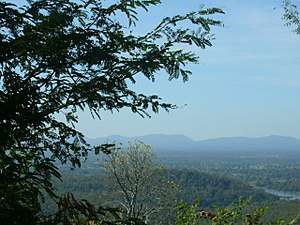 View from Wat Tham Kham | |
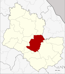 District location in Sakon Nakhon Province | |
| Coordinates: 17°21′6″N 103°50′48″E | |
| Country | Thailand |
| Province | Sakon Nakhon |
| Area | |
| • Total | 673.798 km2 (260.155 sq mi) |
| Population (2005) | |
| • Total | 79,507 |
| • Density | 118.0/km2 (306/sq mi) |
| Time zone | UTC+7 (ICT) |
| Postal code | 47130 |
| Geocode | 4704 |
Geography
Neighboring districts are (from the east clockwise) Mueang Sakon Nakhon, Kut Bak, Nikhom Nam Un, Waritchaphum, Phang Khon, Wanon Niwat and Akat Amnuai of Sakon Nakhon Province, and Na Wa of Nakhon Phanom Province.
History
The area was originally known as Ban Phang Phrao (บ้านพังพร้าว). It was renamed Phanna Nikhom and made a district in 1902.
Administration
The district is divided into 10 sub-districts (tambons), which are further subdivided into 123 villages (mubans). Phanna Nikhom is a township (thesaban tambon) which covers parts of tambon Phanna. There are a further 10 tambon administrative organizations (TAO).
| No. | Name | Thai name | Villages | Pop. | |
|---|---|---|---|---|---|
| 1. | Phanna | พรรณา | 11 | 8,636 | |
| 2. | Wang Yang | วังยาง | 10 | 8,044 | |
| 3. | Phok Noi | พอกน้อย | 11 | 8,737 | |
| 4. | Na Hua Bo | นาหัวบ่อ | 15 | 10,232 | |
| 5. | Rai | ไร่ | 15 | 9,268 | |
| 6. | Chang Ming | ช้างมิ่ง | 18 | 9,112 | |
| 7. | Na Nai | นาใน | 11 | 7,385 | |
| 8. | Sawang | สว่าง | 12 | 6,962 | |
| 9. | Ba Hi | บะฮี | 10 | 6,152 | |
| 10. | Choeng Chum | เชิงชุม | 10 | 4,979 |
References
This article is issued from Wikipedia. The text is licensed under Creative Commons - Attribution - Sharealike. Additional terms may apply for the media files.