Petaling District
The Petaling District is a district located in the heart of Selangor in Malaysia, not to be confused with the city of Petaling Jaya located in it, nor the mukims of Petaling within Petaling Jaya City Council within Petaling district.
Petaling District | |
|---|---|
| Daerah Petaling | |
| Other transcription(s) | |
| • Jawi | ڤتاليڠ |
| • Chinese | 八打灵县 |
| • Tamil | பெட்டாலிங் |
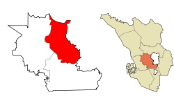
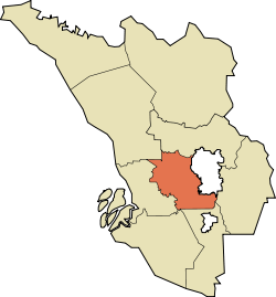 Location of Petaling District in Selangor | |
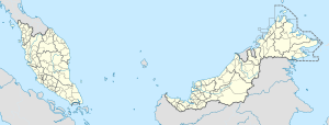 Petaling District Location of Petaling District in Malaysia | |
| Coordinates: 3°05′N 101°35′E | |
| Country | |
| State | |
| Seat | Subang |
| Largest city | Petaling Jaya |
| Local area government(s) | Petaling Jaya City Council (East) Shah Alam City Council (West) Subang Jaya Municipal Council (South) |
| Government | |
| • District officer | Misri Idris[1] |
| • Sultan's Representative | Emran Kadir[2] |
| Area | |
| • Total | 484.32 km2 (187.00 sq mi) |
| Population (2010)[4] | |
| • Total | 1,660,869 |
| • Density | 3,400/km2 (8,900/sq mi) |
| Time zone | UTC+8 (MST) |
| • Summer (DST) | UTC+8 (Not observed) |
| Postcode | 40xxx, 43xxx, 46xxx, 47xxx |
| Calling code | +6-03-5, +6-03-6, +6-03-7, +6-03-8 |
| Vehicle registration plates | B |
The district of Petaling was established on 1 February 1974, the same day Kuala Lumpur was declared a Federal Territory. This district is located in the middle of the Klang Valley adjacent the capital, and thus has experienced tremendous urbanization. During the 1991 census, it recorded 633,165 people. In the official 2010 census, it recorded 1,660,869 people. (exclude foreign)[4] It covers some 484.32 km² in area.[3] The urban centres are divided into the cities of Shah Alam and Petaling Jaya and the municipal of Subang Jaya . However, there are numerous town subdivisions, old subdistrict administrations (mukim), all of which share the same names like Damansara, Subang, and Petaling, which add much to the administrative confusion along with the rapid growth. Some five types of subdivisions exist for Petaling District, namely the re-organized municipal council majlis, the majlis subdivisions, the community names (also known as townships), electoral constituencies, and the subdivisions ("mukim").
It is host to many thriving townships such as the Damansara area, which hosts several shopping malls including a Tesco and an IKEA outlet. Sultan Abdul Aziz Shah Airport is situated in Subang.
The district office is located in Subang.
Population
The following is based on Department of Statistics Malaysia 2010 census.[4]
| Ethnic groups in Petaling , 2010 census | ||
|---|---|---|
| Ethnicity | Population | Percentage |
| Bumiputera | 873,787 | 48.20% |
| Chinese | 580,639 | 32.03% |
| Indian | 193,044 | 10.65% |
| Others | 13,399 | 0.74% |
| Total | 1,812,633 | 100% |
Administrative divisions
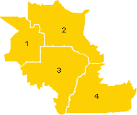
Petaling District is divided into 4 mukims. However, this definition is for historic administrative purposes only and does not reflect modern rapid growth and subsequent reorganization in 1997.
|
 |
Government

The district is highly urbanized and as such the actual administration and maintenance of the public facilities in the district have been divided and delegated to the three local governments.
Shah Alam City Council
The Shah Alam City Council (MBSA) governs the city centre of Shah Alam. It also exercises jurisdiction over some parts of the south of Klang District, Bukit Raja, Setia Alam, Subang and Sungai Buloh area.
Petaling Jaya City Council
The city council (MBPJ) administers the area of the city of Petaling Jaya which includes Damansara (Petaling Jaya Utara, PJU), Petaling Jaya centre and most part of Petaling Jaya Selatan (PJS) except PJS7/PJS9/PJS11 (commonly known as Bandar Sunway) which is partially jurisdictional and postcode allocated for location purposes, and SS12-SS19 which previously administrates under MBPJ previous incarnation Petaling Jaya Municipal Council (MPPJ), was transfer the administration power to Subang Jaya Municipal Council (MPSJ) on 1997, the same year MPSJ was upgraded from Petaling District Council.
Subang Jaya City Council
The city council governs the southern parts of the district with the main populated areas such as Subang Jaya, UEP Subang Jaya (USJ), Putra Heights, Batu Tiga, parts of Puchong and Seri Kembangan under its jurisdiction.
Federal Parliament and State Assembly Seats
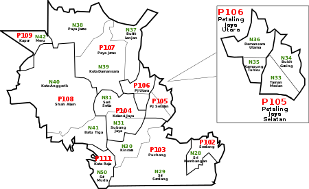
List of Petaling district representatives in the Federal Parliament (Dewan Rakyat)
| Parliament | Seat Name | Member of Parliament | Party |
|---|---|---|---|
| P103 | Puchong | Gobind Singh Deo | Pakatan Harapan (PH) |
| P104 | Subang | Wong Chen | Pakatan Harapan (PH) |
| P105 | Petaling Jaya | Maria Chin Abdullah | Pakatan Harapan (PH) |
| P106 | Damansara | Tony Pua Kiam Wee | Pakatan Harapan (PH) |
| P107 | Sungai Buloh | Sivarasa K. Rasiah | Pakatan Harapan (PH) |
| P108 | Shah Alam | Khalid Abd Samad | Pakatan Harapan (PH) |
| P109 | Kapar | Abdullah Sani Abdul Hamid | Pakatan Harapan (PH) |
| P111 | Kota Raja | Mohammad Sabu | Pakatan Harapan (PH) |
List of Petaling district representatives in the State Legislative Assembly (Dewan Undangan Negeri)
| Parliament | State | Seat Name | State Assemblyman | Party |
|---|---|---|---|---|
| P103 | N28 | Sri Kembangan | Ean Yong Hian Wah | Pakatan Harapan (PH) |
| P103 | N29 | Sri Serdang | Siti Mariah Mahmud | Pakatan Harapan (PH) |
| P104 | N30 | Kinrara | Ng Sze Han | Pakatan Harapan (PH) |
| P104 | N31 | Subang Jaya | Michelle Ng Mei Sze | Pakatan Harapan (PH) |
| P105 | N32 | Seri Setia | Halimey Abu Bakar | Pakatan Harapan (PH) |
| P105 | N33 | Taman Medan | Syamsul Firdaus Mohamed Supri | Pakatan Harapan (PH) |
| P105 | N34 | Bukit Gasing | Rajiv Rishyakaran | Pakatan Harapan (PH) |
| P106 | N35 | Kampung Tunku | Lim Yi Wei | Pakatan Harapan (PH) |
| P106 | N36 | Bandar Utama | Jamaliah Jamaluddin | Pakatan Harapan (PH) |
| P106 | N37 | Bukit Lanjan | Wong Keat Ping | Pakatan Harapan (PH) |
| P107 | N38 | Paya Jaras | Mohd Khairuddin Othman | Pakatan Harapan (PH) |
| P107 | N39 | Kota Damansara | Shatiri Mansor | Pakatan Harapan (PH) |
| P108 | N40 | Kota Anggerik | Mohd Najwan Halimi | Pakatan Harapan (PH) |
| P108 | N41 | Batu Tiga | Rodziah Ismail | Pakatan Harapan (PH) |
| P109 | N42 | Meru | Mohd Fakhrulrazi Mohd Mokhtar | Pakatan Harapan (PH) |
| P111 | N50 | Kota Kemuning | Ganabatirau Veraman | Pakatan Harapan (PH) |
Education
National education is under the purview of the Petaling District Education Office. As of 2005, there were 99 national type primary schools, 16 national type (Chinese) primary schools, 16 national type (Tamil) primary schools, 65 national type secondary schools, 35 international and private schools, one technical secondary school and one special education school.
References
- "Portal Rasmi PDT Petaling Senarai Pegawai Daerah Petaling". www2.selangor.gov.my.
- "Portal Rasmi PDT Petaling Orang Besar Daerah". www2.selangor.gov.my.
- "Portal Rasmi PDT Petaling Sejarah Daerah Petaling". www2.selangor.gov.my.
- "Population Distribution and Basic Demographic Characteristics, 2010" (PDF). Department of Statistics, Malaysia. Archived from the original (PDF) on 22 May 2014. Retrieved 19 April 2012.
