Jeli District
The Jeli District (Jawi: جلي) is a district and a parliamentary constituency in western Kelantan, Malaysia. As of 2010, the district's population is estimated to be 42,150. Jeli is administered by the Jeli District Council. Jeli is bordered by the state of Perak to the west, the Thai district of Waeng to the north, Tanah Merah district to the north east and Kuala Krai district to the south east.
Jeli District | |
|---|---|
| Jajahan Jeli | |
| Other transcription(s) | |
| • Jawi | جلي |
| • Chinese | 日里县 |
| • Tamil | ஜெலி |
 Flag | |
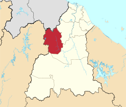 Location of Jeli District in Kelantan | |
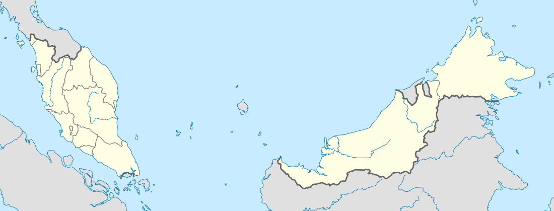 Jeli District Location of Jeli District in Malaysia | |
| Coordinates: 5°42′N 101°50′E | |
| Country | |
| State | |
| Establishment | 1986[1] |
| Seat | Jeli |
| Local area government(s) | Jeli District Council |
| Government | |
| • District officer | Nik Raisnan Daud[2] |
| Area | |
| • Total | 1,280.21 km2 (494.29 sq mi) |
| Population (2010)[4] | |
| • Total | 40,637 |
| • Density | 32/km2 (82/sq mi) |
| Time zone | UTC+8 (MST) |
| • Summer (DST) | UTC+8 (Not observed) |
| Postcode | 176xx |
| Calling code | +6-09 |
| Vehicle registration plates | D |
Most people in Jeli work as rubber tappers. The rubber plantations which belong to the local people also attract people from outside to come and work. Commonly families own a small plantation of 6 acres (24,000 m2) up to 50 acres (200,000 m2) in size. The history of Jeli began when the government encouraged the people around Kelantan to start a great area of agriculture. This process began with a period of land clearing, or logging.
History
Jeli district (jajahan) was originally an autonomous sub-district (Jajahan Kecil), formed on 1 July 1982 from parts of Tanah Merah (Jeli and Belimbing) and Kuala Krai (Kuala Balah) district. It was elevated to a full district on 1 January 1986 and made a full parliamentary constituency in the 1995 elections. Being a totally new residential area, initially Jeli had residents coming from other parts of Kelantan. Jeli became host to thousands of hopefuls from all over Kelantan during the late 70's and early 80's, hoping to get a fresh start in this district. While the first generations of Jeli residents mostly involved in rubber tapping and other forms of plantantions for a living, the current generations have managed to find their way up to a much better profession, thanks to the proper education system and dedicated teachers available to this remote area.
Population
Jeli as of 2009, it has a population of 46,700 people[3]
Ranking Population of Jeli District.
| Rank | Daerah/Mukim | Population 2000 |
|---|---|---|
| 1 | Jeli town | 17,734 |
| 2 | Kuala Balah | 10,198 |
| 3 | Belimbang | 8,056 |
Politics
The member of Parliament for Jeli is Dato' Mustapa Mohamed, from Parti Pribumi Bersatu Malaysia.
Climate
Batu 13 Jeli is the wettest place in Malaysia with more than 6,000 mm (240 in) of mean rainfall annually. In 2011 8,596 mm (338.4 in) of rainfall was recorded in Batu 13 Jeli, the highest annual rainfall recorded in Malaysia.
Education
There are a number of schools which serve the population of Jeli. The primary schools in Jeli include Sekolah Kebangsaan Batu Melintang, Sekolah Kebangsaan Pendok, Sekolah Kebangsaan Sungai Long, Sekolah Kebangsaan Jeli 1, Sekolah Kebangsaan Kalai (Kalai National School), Sekolah Kebangsaan Jeli 2 and Sekolah Kebangsaan Bukit Jering. Jeli also has a MARA junior science college, Maktab Rendah Sains MARA Jeli, which is an example of Malaysia's boarding schools. Jeli now has a new boarding school there which is SM Sains Jeli known as JeSS.
Currently, two higher learning institutions, Universiti Malaysia Kelantan and Politeknik Jeli are located here in Jeli. Politeknik Jeli is currently under construction and is scheduled to be completed in a few months. Universiti Malaysia Kelantan has been operating since 2012.
Tourism
The main attraction of this district is the Stong Waterfalls. Towering at a height of 305 m, this scenic waterfall is the tallest waterfall in the South East Asia region.Another attraction at Jeli is Jeli Hot Spring, one of the hottest hot springs in Malaysia. Jeli Hot Spring is located about 15 km from Jeli town. Jeli hot spring has a higher health value as it has a high sulphur content. Other attractions include Lata Janggut, Lata Renyok and Lata Chenang.
Transportation
Highway 4 is the main road in the constituency, going in an east-west direction. To the west it goes to Gerik, Perak and all the way to Kedah and Penang; to the east it continues to Pasir Puteh. Jeli is therefore known as the 'western gateway' into the East Coast for visitors from Penang, Kedah and Perlis.
The junction of highways 4 and Highway 66 is located near Jeli town. Highway 66 leads to Kuala Balah in the southern part of Jeli constituency, and is a shortcut to the railway town of Dabong and Kuala Krai.
References
- User, Super. "Laman Web Rasmi Pejabat Tanah Dan Jajahan Jeli - Sejarah Jajahan". www.ptjj.kelantan.gov.my. Archived from the original on 2017-11-12. Retrieved 2017-11-27.
- User, Super. "Laman Web Rasmi Pejabat Tanah Dan Jajahan Jeli - Perutusan Ketua Jajahan". www.ptjj.kelantan.gov.my. Archived from the original on 2017-11-12. Retrieved 2017-11-27.
- User, Super. "Laman Web Rasmi Pejabat Tanah Dan Jajahan Jeli - Keluasan Dan Penduduk". www.ptjj.kelantan.gov.my. Archived from the original on 2017-11-12. Retrieved 2017-11-27.
- "Population Distribution and Basic Demographic Characteristics, 2010" (PDF). Department of Statistics, Malaysia. Archived from the original (PDF) on 22 May 2014. Retrieved 19 April 2012.
Capital: Kota Bharu | |||||||
| Topics |
| ||||||
| Society |
| ||||||
| Administrative divisions |
| ||||||
| |||||||