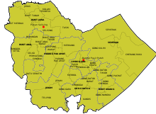
Pasir Puteh District
Pasir Puteh District is a district (jajahan) in Kelantan, Malaysia. The town of Pasir Putih is situated on the bank of Semerak River, about 30 kilometers to the south of Kota Bharu. Pasir Puteh district borders Terengganu to its south-east.
Pasir Puteh District | |
|---|---|
| Jajahan Pasir Puteh | |
| Other transcription(s) | |
| • Jawi | ڤاسير ڤوتيه |
| • Chinese | 巴西富地县 |
| • Tamil | பாசிர் பூத்தே |
 Flag | |
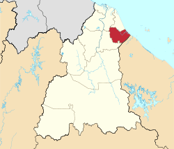 Location of Pasir Puteh District in Kelantan | |
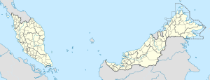 Pasir Puteh District Location of Pasir Puteh District in Malaysia | |
| Coordinates: 5°50′N 102°24′E | |
| Country | |
| State | |
| Seat | Pasir Puteh |
| Local area government(s) | Pasir Puteh District Council |
| Government | |
| • District officer | Abdul Pattah Hasbullah[1] |
| Area | |
| • Total | 433.8 km2 (167.5 sq mi) |
| Population (2010)[3] | |
| • Total | 117,383 |
| • Density | 270/km2 (700/sq mi) |
| Time zone | UTC+8 (MST) |
| • Summer (DST) | UTC+8 (Not observed) |
| Postcode | 16xxx |
| Calling code | +6-09 |
| Vehicle registration plates | D |
History
Before this place was known as Pasir Puteh, it was known as Pangkalan Limbungan. The town of Pasir Puteh derived its name after Sultan Muhammad IV visited this place. The Sultan was very impressed to see the white sand shining along the riverbanks. Hence in 1911, the Sultan declared the name of this place as Pasir Puteh, which meant white sand. This is the place where a Kelantan warrior, Tok Janggut, raised an army of Malay warriors to oppose the introduction of taxation in Kelantan.[2]
Demographics
Population in Pasir Puteh is about 117,383 (2010).[3]
Ranking Population of Jajahan Pasir Puteh.
| Rank | Daerah/Mukim | Population 2000 |
|---|---|---|
| 1 | Semerak | 21,670 |
| 2 | Bukit Jawa | 19,329 |
| 3 | Limbongan (Pasir Puteh Town) | 14,164 |
| 4 | Padang Pak Amat | 13,360 |
| 5 | Bukit Abal | 10,624 |
| 6 | Gong Datok | 8,721 |
| 7 | Jeram | 8,552 |
| 8 | Bukit Awang | 7,984 |
Education
Several types of schools can be found in Pasir Puteh.[4] Among the schools in Pasir Puteh are
- Sekolah Menengah Kebangsaan Bukit Jawa, Selising, 16810 Pasir Puteh
- Sekolah Menengah Kebangsaan Cherang Ruku, Jalan Besut, 16700 Pasir Puteh
- Sekolah Menengah Kebangsaan Gaal, Jalan Jerteh, 16800 Pasir Puteh
- Sekolah Menengah Kebangsaan Jeram, Jalan Pasir Puteh - Machang, 16800 Pasir Puteh
- Sekolah Menengah Kebangsaan Kamil, 16800 Pasir Puteh
- Sekolah Menengah Kebangsaan Dato' Ismail, Jalan Lapangan Terbang TUDM, Gong Kedak, 16800 Pasir Puteh
- Sekolah Menengah Kebangsaan Seri Aman, Jalan Taman Kobena, 16800 Pasir Puteh
- Sekolah Menengah Kebangsaan Sri Maharaja, Bukit Abal, Selising, 16810 Pasir Puteh
- Sekolah Menengah Kebangsaan Tok Janggut, Jalan Pasir Puteh - Kota Bharu, 16800 Pasir Puteh
- Sekolah Menengah Kebangsaan Padang Pak Amat, Kampung Padang Pak Amat, 16800 Pasir Puteh
- Sekolah Menengah Sains Pasir Puteh, Jalan Jeram Pasu, 16800 Pasir Puteh
References
- "Perutusan Ketua Jajahan - Laman Web Rasmi Pejabat Tanah Dan Jajahan Pasir Puteh". ptjpp.kelantan.gov.my.
- "Latar Belakang - Laman Web Rasmi Pejabat Tanah Dan Jajahan Pasir Puteh". ptjpp.kelantan.gov.my.
- "Population Distribution and Basic Demographic Characteristics, 2010" (PDF). Department of Statistics, Malaysia. Archived from the original (PDF) on 22 May 2014. Retrieved 19 April 2012.
- "Secondary Schools in Kelantan, Malaysia". 2007. Retrieved 2007-12-10.
| Wikimedia Commons has media related to Pasir Puteh District. |
Capital: Kota Bharu | |||||||
| Topics |
| ||||||
| Society |
| ||||||
| Administrative divisions |
| ||||||
| |||||||