Johor Bahru District
The Johor Bahru District is a district located in the southern part of Johor, Malaysia. The heavily suburban/suburbanizing district covers an area of 1,063.97 km2 (410.80 sq mi) and has a population of 1.33 million. The district capital is Johor Bahru City and the administrative capital is Iskandar Puteri City. The district borders Pontian District on the west, Kota Tinggi District on the east, Kulai District on the north and Straits of Johor to the south. The urban centres are divided into the cities of Johor Bahru and Iskandar Puteri and the municipal of Pasir Gudang.
Johor Bahru District | |
|---|---|
| Daerah Johor Bahru | |
| Other transcription(s) | |
| • Jawi | جوهر بهرو |
| • Chinese | 新山县 |
| • Tamil | ஜொகூர் பாரு |
 Flag | |
 Location of Johor Bahru District in Johor | |
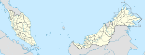 Johor Bahru District Location of Johor Bahru District in Malaysia | |
| Coordinates: 1°32′N 103°43′E | |
| Country | |
| State | |
| Seat | Johor Bahru |
| Local area government(s) | Iskandar Puteri City Council (Johor Bahru West and North) Johor Bahru City Council (Johor Bahru City Centre) Pasir Gudang Municipal Council (Johor Bahru East) |
| Government | |
| • District officer | Haji Abdul Rahman bin Salleh |
| Area | |
| • Total | 1,063.97 km2 (410.80 sq mi) |
| Population (2010)[2] | |
| • Total | 1,265,545 |
| • Density | 1,200/km2 (3,100/sq mi) |
| Time zone | UTC+8 (MST) |
| • Summer (DST) | UTC+8 (Not observed) |
| Postcode | 79xxx - 81xxx |
| Calling code | +6-07-2, +6-07-3, +6-07-5 |
| Vehicle registration plates | J |
.jpg)
It is host to many thriving townships such as the Tebrau area, which hosts several shopping malls including a ÆON Mall, Tesco, Toppen Shopping Centre and an IKEA outlet.
The district office is located in Johor Bahru.
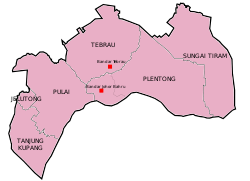
Administrative divisions
Johor Bahru District is divided into 7 mukims, which are:[3][4]。
| UPI Code | Mukim | Population (2010 Census[5]) |
Area (km2[6]) |
Densiy (km2 per person) |
|---|---|---|---|---|
 Bandar Johor Bahru
Tebrau
Plentong
Sungai Tiram
Pulai
Jelutong
Tanjung Kupang
| ||||
| 010201 | Jelutong | 14,651 | 15.281 | 958.77 |
| 010202 | Plentong | 494,152 | 264.439 | 1868.68 |
| 010203 | Pulai | 360,642 | 210.567 | 1712.72 |
| 010206 | Sungai Tiram | 13,348 | 234.913 | 56.82 |
| 010207 | Tanjung Kupang | 10,972 | 84.434 | 129.95 |
| 010208 | Tebrau | 316,327 | 218.078 | 1450.52 |
| 010240 | Bandar Johor Bahru | 124,096 | 36.260 | 3422.39 |
Cities and Towns
There are two towns (Bandar) in Johor Bahru District.[3]
| Type | UPI Code | City/Town |
|---|---|---|
| Town (Bandar) | 010240 | Johor Bahru |
| 010242 | Tebrau |
Government
The district is highly urbanized have been divided and delegated to the three local governments with Johor Bahru City as the capital of Johor Bahru District, which are:
Johor Bahru City Council
The Johor Bahru City Council (MBJB) governs the city centre of Johor Bahru. It also exercises jurisdiction includes Larkin, Tebrau, Ulu Tiram, Bandar Dato Onn, Kempas, Tampoi, Kempas, Johor Jaya, Permas Jaya and partly Taman Rinting.
Iskandar Puteri City Council
The city council (MBIP) administers the area of the city of Iskandar Puteri which includes Skudai, Gelang Patah, Taman Perling, Kangkar Pulai, Tanjung Kupang and Tanjung Pelepas.
Pasir Gudang Municipal Council
The municipal council governs the eastern parts of the district with the populated areas such as Pasir Gudang, Masai, Bandar, Seri Alam, Taman Kota Masai, Kong Kong and Sungai Tiram.
Other Towns
Federal Parliament and State Assembly Seats
| DAP (PH) | 1 / 5 |
|---|---|
| PKR (PH) | 3 / 5 |
| AMANAH (PH) | 1 / 5 |

List of Johor Bahru district representatives in the Federal Parliament (Dewan Rakyat)
| Parliament | Seat Name | Member of Parliament | Party |
|---|---|---|---|
| P158 | Tebrau | Choong Shiau Yoon | Pakatan Harapan (PKR) |
| P159 | Pasir Gudang | Hassan Bin Abdul Karim | Pakatan Harapan (PKR) |
| P160 | Johor Bahru | Akmal Nasrullah Bin Mohd Nasir | Pakatan Harapan (PKR) |
| P161 | Pulai | Salahuddin Bin Ayub | Pakatan Harapan (AMANAH) |
| P162 | Iskandar Puteri | Lim Kit Siang | Pakatan Harapan (DAP) |
List of Johor Bahru district representatives in the State Legislative Assembly (Dewan Undangan Negeri)
| Parliament | State | Seat Name | State Assemblyman | Party |
|---|---|---|---|---|
| P158 | N40 | Tiram | Gopalakrishnan A/L Subramaniam | Pakatan Harapan (PKR) |
| P158 | N41 | Puteri Wangsa | Mazlan Bin Bujang | Pakatan Harapan (PPBM) |
| P159 | N42 | Johor Jaya | Liow Cai Tung | Pakatan Harapan (DAP) |
| P159 | N43 | Permas | Che Zakaria Bin Mohd Salleh | Pakatan Harapan (PPBM) |
| P160 | N44 | Larkin | Mohd Izhar Bin Ahmad | Pakatan Harapan (PPBM) |
| P160 | N45 | Stulang | Chen Kah Eng | Pakatan Harapan (DAP) |
| P161 | N46 | Perling | Cheo Yee How | Pakatan Harapan (DAP) |
| P161 | N47 | Kempas | Osman Bin Sapian | Pakatan Harapan (PPBM) |
| P162 | N48 | Skudai | Tan Hong Pin | Pakatan Harapan (DAP) |
| P162 | N49 | Kota Iskandar | Dzulkefly Bin Ahmad | Pakatan Harapan (AMANAH) |
Economy
The main economy activities in the district are international trading, manufacturing, medical and healthcare.[7]
Education
There are a total of 41 secondary schools, one religious school, three vocational schools, one technical secondary school and one fully residential school.[8]
Transportation
Rail
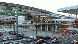
The district has two railway stations, which are Johor Bahru Sentral and Kempas Baru.
Road
The Johor Bahru Eastern Dispersal Link Expressway, Pasir Gudang Highway, Johor Bahru East Coast Highway, Iskandar Coastal Highway, Skudai–Pontian Highway, Skudai Highway, Johor Bahru–Kota Tinggi Highway and Senai–Desaru Expressway links most of the cities and towns in Johor Bahru District. The district is linked to other districts in Johor and other states in Peninsular Malaysia via the North–South Expressway.
Singapore
The district is also linked to Singapore via Johor–Singapore Causeway and Malaysia–Singapore Second Link.
Sea
Ports in the district are Johor Port, Tanjung Langsat Port and Port of Tanjung Pelepas.
References
- http://ptj.johor.gov.my/index.php/pejabat-tanah/pejabat-tanah-johor-bahru/profil-ptjb-2
- "Population Distribution and Basic Demographic Characteristics, 2010" (PDF). Department of Statistics, Malaysia. Archived from the original (PDF) on 22 May 2014. Retrieved 19 April 2012.
- "Kod dan Nama Sempadan Pentadbiran Tanah, Unique Parcel Identifier (UPI) JOHOR" (PDF). Jawatankuasa Teknikal Standard MyGDI (JTSM). 2011.
- "Profil Daerah Johor Bahru" (PDF). Jabatan Pengairan dan Saliran Daerah Johor Bahru.
- Taburan Penduduk Mengikut Kawasan Pihak Berkuasa Tempatan dan Mukim 2010 (PDF). Putrajaya: Jabatan Perangkaan Malaysia. 2011. ISBN 978-983-9044-59-1.
- "Profil Daerah Johor Bahru". Laman Rasmi Pentadbiran Tanah Johor (in Malay). Pejabat Tanah Johor Bahru. Retrieved 25 December 2018.
- "Muafakat ke Arah #Johor Berkemajuan" (PDF). Muafakat Johor (in Malay). Retrieved 17 March 2018.
- "Senarai Sekolah Daerah Johor Bahru" (in Malay). Johor Bahru District Education Office. Archived from the original on 4 August 2015. Retrieved 4 August 2015.
External links
| Wikimedia Commons has media related to Johor Bahru District. |