Rahatgarh
Rahatgarh is a town and a nagar panchayat in Sagar district in the Indian state of Madhya Pradesh.
Rahatgarh | |
|---|---|
Town | |
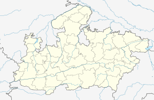 Rahatgarh Location in Madhya Pradesh, India  Rahatgarh Rahatgarh (India) | |
| Coordinates: 23.78°N 78.37°E | |
| Country | |
| State | Madhya Pradesh |
| District | Sagar |
| Elevation | 461 m (1,512 ft) |
| Population (2011)[1] | |
| • Total | 31,537 |
| Time zone | UTC+5:30 (IST) |
| PIN | 470119 |
| Telephone code | +917584 |
| ISO 3166 code | IN-MP |
| Vehicle registration | mp 15 |
History
An inscription of the Paramara king Jayavarman II, dated 28 August 1256 CE, was issued at Rahatgarh. It is possible that Jayavarman captured the area from the Chandelas. [2]
Geography
Rahatgarh is located at 23.78°N 78.37°E.[3] It has an average elevation of 461 metres (1,512 feet).
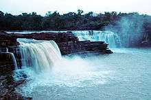
Rahatgarth Waterfall
The town is also notable for the Rahatgarh waterfall.
Demographics
As of 2001 India census,[4] Rahatgarh had a population of 25,217. Males constitute 53% of the population and females 47%. Rahatgarh has an average literacy rate of 51%, lower than the national average of 59.5%: male literacy is 61%, and female literacy is 40%. In Rahatgarh, 19% of the population is under 6 years of age.
References
- "Census of India Search details". censusindia.gov.in. Retrieved 10 May 2015.
- Harihar Vitthal Trivedi (1991). Inscriptions of the Paramāras (Part 2). Corpus Inscriptionum Indicarum Volume VII: Inscriptions of the Paramāras, Chandēllas, Kachchapaghātas, and two minor dynasties. Archaeological Survey of India. pp. 190–191. doi:10.5281/zenodo.1451755.
- Falling Rain Genomics, Inc - Rahatgarh
- "Census of India 2001: Data from the 2001 Census, including cities, villages and towns (Provisional)". Census Commission of India. Archived from the original on 16 June 2004. Retrieved 1 November 2008.
This article is issued from Wikipedia. The text is licensed under Creative Commons - Attribution - Sharealike. Additional terms may apply for the media files.