Gunma Prefecture
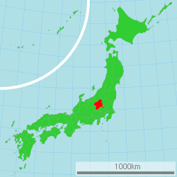
Gunma Prefecture (群馬県, Gunma-ken) is a prefecture of Japan located in the Kantō region.[1] Its capital is Maebashi.[2]
Gunma Prefecture 群馬県 | |
|---|---|
| Japanese transcription(s) | |
| • Japanese | 群馬県 |
| • Rōmaji | Gunma-ken |
 Flag  Symbol | |
 | |
| Country | Japan |
| Region | Kantō |
| Island | Honshu |
| Capital | Maebashi |
| Subdivisions | Districts: 7, Municipalities: 35 |
| Government | |
| • Governor | Ichita Yamamoto |
| Area | |
| • Total | 6,362.28 km2 (2,456.49 sq mi) |
| Area rank | 21st |
| Population (October 1, 2019) | |
| • Total | 1,937,626 |
| • Rank | 19th |
| • Density | 300/km2 (790/sq mi) |
| ISO 3166 code | JP-10 |
| Website | www |
| Symbols | |
| Bird | Copper pheasant (Phasianus soemmerringii) |
| Fish | Sweetfish (Plecoglossus altivelis) |
| Flower | Japanese azalea (Rhododendron japonicum) |
| Tree | Japanese black pine (Pinus thunbergii) |
History
The ancient province of Gunma was a center of horsebreeding and trading activities for the newly immigrated continental peoples. The arrival of horses and the remains of horse-tackle coincides with the arrival of a large migration from the mainland. From this point forward, the horse became a vital part of Japanese military maneuvers, quickly displacing the older Yayoi tradition of fighting on foot.
When Mount Haruna erupted in the late 6th century, Japan was still in the pre-historical phase (prior to the importation of the Chinese writing system during the Nara period). The Gunma Prefectural archaeology unit in 1994 was able to date the eruption through zoological anthropology at the corral sites that were buried in ash.
In the past, Gunma was joined with Tochigi Prefecture and called Kenu Province. This was later divided into Kami-tsu-ke (Upper Kenu, Gunma) and Shimo-tsu-ke (Lower Kenu, Tochigi). The area is sometimes referred to as Jomo (上毛, Jōmō). For most of Japanese history, Gunma was known as the province of Kozuke.[3]
In the early period of contact between western nations and Japan, particularly the late Tokugawa, it was referred to by foreigners as the "Joushu States", inside (fudai, or loyalist) Tokugawa retainers and the Tokugawa family symbol is widely seen on public buildings, temples and shrines.
The first modern silk factories were built with Italian and French assistance at Annaka in the 1870s.
In the early Meiji period, in what was locally called the Gunma Incident of 1884, a bloody struggle between the idealistic democratic westernizers and the conservative Prussian-model nationalists took place in Gunma and neighboring Nagano. The modern Japanese army gunned down farmers with new repeating rifles built in Japan. The farmers in Gunma were said to be the first victims of the Murata rifle.
In the twentieth century, the Japanese aviation pioneer Nakajima Chikushi of Oizumi, Gunma Prefecture, founded the Nakajima Aircraft Company. At first, he produced mostly licensed models of foreign designs, but beginning with the all-Japanese Nakajima 91 fighter plane in 1931, his company became a world leader in aeronautical design and manufacture, with its headquarters at Ota, Gunma Ken. The factory now produces Subaru motorcars and other products under the name of Fuji Heavy Industries.
In the 1930s, German architect Bruno Julius Florian Taut lived and conducted research for a while in Takasaki.
The Girard incident, which disturbed US-Japanese relations in the 1950s, occurred in Gunma in 1957, at Soumagahara Base near Shibukawa.
Four modern prime ministers are from Gunma, namely, Takeo Fukuda, Yasuhiro Nakasone, Keizo Obuchi, and Yasuo Fukuda, the son of Takeo.
Geography


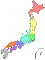
One of only eight landlocked prefectures in Japan, Gunma is the northwesternmost prefecture of the Kantō plain. Except for the central and southeast areas, where most of the population is concentrated, it is mostly mountainous. To the north are Niigata and Fukushima prefectures, while to the east lies Tochigi Prefecture. To the west lies the Nagano Prefecture, and the Saitama Prefecture is to the south.
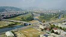
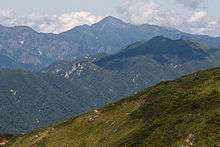
Some of the major mountains in Gunma are Mount Akagi, Mount Haruna, Mount Myōgi, Mount Nikkō-Shirane and Mount Asama, which is located on the Nagano border. Major rivers include the Tone River, the Agatsuma River, and the Karasu River.
As of 1 April 2012, 14% of the total land area of the prefecture was designated as Natural Parks, namely Jōshin'etsu-kōgen, Nikkō, and Oze National Parks and Myōgi-Arafune-Saku Kōgen Quasi-National Park.[4]
Cities
Twelve cities are located in Gunma Prefecture:
Mergers
Climate
Because Gunma is situated in inland Japan, the difference in temperature in the summer compared to the winter is large, and there is less precipitation. This is because of the kara-kaze ("empty wind"), a strong, dry wind which occurs in the winter when the snow falls on the coasts of Niigata. The wind carrying clouds with snow are obstructed by the Echigo Mountains, and it also snows there, although the high peaks do not let the wind go past them. For this reason, the wind changes into the kara-kaze.
- Climate in Maebashi
- Average yearly precipitation: 1,163 mm (approx. 45.8in)
- Average yearly temperature: 14.2 degrees Celsius (approx. 57.6 degrees Fahrenheit)
Economy
Gunma's modern industries include transport equipment and electrical equipment, concentrated around Maebashi and the eastern region nearest Tokyo. More traditional industries include sericulture and agriculture. Gunma's major agricultural products include cabbages and konjacs. Gunma produces 90% of Japan's konjacs, and two-thirds of the farms in the village of Tsumagoi are cabbage farms. Also, the city of Ōta is famous for car industry, notably the Subaru factory.
Culture
Gunma has a traditional card game called Jomo Karuta (上毛かるた).
Kiyoshi Ogawa, a Kamikaze pilot who led the attack on the USS Bunker Hill was born in Gunma.
Melody Roads
As of 2018, Gunma is home to eleven of Japan's over thirty Melody Roads. 2,559 grooves cut into a 175-meter stretch of the road surface in transmit a tactile vibration through the wheels into the car body.[5][6] [7] The roads can be found in Katashina, Minakami, Takayama, Kanna, Ueno, Kusatsu, Tsumagoi, Nakanojo, Takasaki, Midori, and Maebashi. Each is of a differing length and plays a different song. Naganohara also used to be home to a Melody Road playing “Aj, lučka lučka siroka”, though the road in question was paved over in 2013 due to noise complaints.
Songs
- Kusatsu - “Kusatsu-Bushi”
- Takayama - “When You Wish Upon a Star”
- Tsumagoi - “Oh My Darling Clementine”
- Nakanojo - “Always With Me” (Japanese title: いつも何度でも, itsumo nando demo) from Spirited Away when driven at 40km/h
- Katashina - “Memories of Summer” when driven over at 50 km/h
List of Governors of Gunma Prefecture (1947–present)
| Governor | Term start | Term end |
|---|---|---|
| Shigeo Kitano (北野重雄) | 12 April 1947 | 25 June 1948 |
| Yoshio Iyoku (伊能芳雄) | 10 August 1948 | 4 July 1952 |
| Shigeo Kitano | 2 August 1952 | 1 August 1956 |
| Toshizo Takekoshi (竹腰俊蔵) | 2 August 1956 | 1 August 1960 |
| Konroku Kanda (神田坤六) | 2 August 1960 | 1 August 1976 |
| Ichiro Shimizu (清水一郎) | 2 August 1976 | 12 June 1991 |
| Hiroyuki Kodera (小寺弘之) | 28 July 1991 | 27 July 2007 |
| Masaaki Osawa (大澤正明) | 28 July, 2007 | Present |
Education
Universities
- Isesaki
- Jobu University – Isesaki Campus
- Tokyo University of Social Welfare – Isesaki Campus
- Maebashi
- Midori
- Ota
- Takasaki
- Takasaki City University of Economics
- Takasaki University of Commerce
- Takasaki University of Health and Welfare
- Gunma Paz College
- Jobu University -Takasaki Campus
- Tamamura
Sports
The sports teams listed below are based in Gunma.
Baseball
Football (soccer)
Rugby
- Panasonic Wild Knights (Ota)
Tourism
Gunma has many hot spring resorts and the most famous is Kusatsu Onsen. Another draw to the mountainous Gunma is the ski resorts.
Other attractions include:
- Lake Nozori
- Hara Museum Arc
- Ikaho Sistina Trick Art Museum
- Mount Haruna
- Kusatsu Alpine-Plant Museum
- Kusatsu Hot-Spring Museum
- Mount Kusatsu-Shirane
- Mount Tanigawa
- Mount Akagi
- Mount Myōgi
- The Museum of Modern Art, Gunma
Transportation
Rail
- JR East
- Joetsu Shinkansen
- Hokuriku Shinkansen
- Takasaki Line
- Shinetsu Line (Takasaki-Yokokawa)
- Joetsu Line
- Agatsuma Line
- Ryomo Line
- Hachiko Line (Kuragano-Hachioji)
- Tobu Railway
- Isesaki Line
- Nikko Line (Itakura Tōyōdai-mae Station)
- Sano Line
- Kiryu Line
- Joshin Electric Railway (Takasaki-Shimonita)
- Jomo Electric Railway (Chuo Maebashi-Nishi Kiryu)
- Watarase Keikoku Railway Watarase Keikoku Line
Roads
Expressways
- Kan-Etsu Expressway
- Tōhoku Expressway
- Jōshin-etsu Expressway
- Kita-Kantō Expressway (Takasaki-Hitachinaka)
National highways
- National Route 17 (Nihonbashi of Tokyo-Saitama-Kumagaya-Takasaki-Shibukawa-Ojiya-Nagaoka)
- National Route 18 (Takasaki-Annaka-Karuizawa-Komoro-Nagano-Myoko-Joetsu)
- National Route 50 (Maebashi-Isesaki-Oyama-Yuki-Mito)
- National Route 120
- National Route 122
- National Route 144
- National Route 145
- National Route 146
- National Route 254
- National Route 291
- National Route 292
- National Route 299
- National Route 353
- National Route 354
- National Route 405
- National Route 406
- National Route 407
- National Route 462
Prefectural symbols
The prefectural symbol consists of the first kanji of the word 'Gunma' surrounded by three stylized mountains symbolizing the three important mountains of Gunma Prefecture: Mount Haruna, Mount Akagi, and Mount Myōgi.
For marketing, the Prefectural Government also uses Gunma-chan, a small super deformed drawing of a gendered horse character wearing a green cap. It is used on promotional posters, banners and other notable printed materials from the Prefectural Government. Other agencies and companies formally or informally use variations of its likeness and other horse-shaped characters when making signs or notices for work on buildings, roads, and other public notices.
Notes
- Nussbaum, Louis-Frédéric. (2005). "Gumma-ken" in Japan Encyclopedia, p. 267, p. 267, at Google Books; "Kantō" in p. 479, p. 479, at Google Books.
- Nussbaum, "Maebashi" in p. 600, p. 600, at Google Books.
- Nussbaum, "Provinces and prefectures" in p. 470, p. 470, at Google Books.
- "General overview of area figures for Natural Parks by prefecture" (PDF). Ministry of the Environment. 1 April 2012. Retrieved 3 December 2013.
- Johnson, Bobbie (13 November 2007). "Japan's melody roads play music as you drive". The Guardian. Farringdon Road, London, England: GMG. p. 19 (International section). Retrieved 20 October 2008.
- "Your car as a musical instrument – Melody Roads". Noise Addicts. 29 September 2008. Retrieved 20 October 2008.
- "Singing Roads – Take a Musical Trip in Japan". ITN. 5 December 2007. Retrieved 20 October 2008.
References
- Nussbaum, Louis-Frédéric and Käthe Roth. (2005). Japan encyclopedia. Cambridge: Harvard University Press. ISBN 978-0-674-01753-5; OCLC 58053128
- "Gunma Prefecture: Location and Topography". Gunma Prefecture HomePage. October 2006. Archived from the original on 2006-10-16. Retrieved 2006-10-19.
External links
| Wikivoyage has a travel guide for Gunma. |
| Wikimedia Commons has media related to Gunma prefecture. |
- Gunma Prefecture Official Website (in Japanese)
- Gunma Prefecture Official Website (in English)
Maebashi (capital) | ||
| Core cities |
| |
| Special cities | ||
| Cities | ||
| Districts | ||
| Authority control |
|
|---|