Norderney
Norderney (Low German: Nördernee) is one of the seven populated East Frisian Islands off the North Sea coast of Germany.
Norderney | |
|---|---|
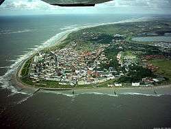 Aerial view of Norderney from the west | |
 Flag  Coat of arms | |
Location of Norderney within Aurich district  | |
 Norderney  Norderney | |
| Coordinates: 53°42′26″N 07°08′49″E | |
| Country | Germany |
| State | Lower Saxony |
| District | Aurich |
| Subdivisions | 2 Ortsteile Fischerhafen, Nordhelmsiedlung |
| Government | |
| • Mayor | Frank Ulrichs (SPD)[1] |
| Area | |
| • Total | 26.3 km2 (10.2 sq mi) |
| Elevation | 5 m (16 ft) |
| Population (2018-12-31)[2] | |
| • Total | 6,089 |
| • Density | 230/km2 (600/sq mi) |
| Time zone | CET/CEST (UTC+1/+2) |
| Postal codes | 26548 |
| Dialling codes | 04932 |
| Vehicle registration | AUR, NOR |
| Website | www.norderney.de |

.JPG)
The island is 14 by 2.5 kilometres (8.7 by 1.6 mi), having a total area of about 26.3 square kilometres (10.2 sq mi) and is therefore Germany's ninth-largest island. Norderney's population amounts to about 5,850[3] people. In 1946 Norderney gained municipal status and belongs to the Aurich "Kreis" (county). On the northern side of the island lies a 14-kilometre (8.7 mi) long sandy beach.
The neighbouring island to the east is Baltrum, which lies about 800m (half a mile) away beyond the Wichter Ee. To the west is the island of Juist, about 3 kilometres (1.9 mi) away on the other side of the Norderneyer Seegatt.
The entire eastern half of Norderney belongs to the Lower Saxon Wadden Sea National Park. Access to the park is restricted, as it is subdivided in zones of different accessibility for the protection of the wildlife. The status as a National Park also affects all kinds of traffic on the island, while especially car traffic is subject to strict regulations.
The mainland is easily reached via ferry operated by AG Reederei Norden-Frisia from the harbour, Norddeich pier near the northern German city of Norden. Norderney also possesses an airport with a 1,000-metre (3,300 ft) runway.
History
Of the seven East Frisian islands, Norderney is the youngest. The island has only existed in its present form since the middle of the 16th century, being the eastern remnant of the larger island Buise. The larger island of Buise was split into two parts during the Grote Mandrenke flood of 1362, the eastern half at first being called Ostrende. What was left of Buise shrank in size over the years and finally disappeared into the North Sea during the St. Peter's Flood of 1651. Ostrende, on the other hand, grew in size, and is noted in a 1550 census as "Norder neys Oog" (Northern New Island), and having a church and 18 houses. The inhabitants at this time worked principally as fishermen. In the second half of the 18th century the sea trade industry grew in importance. Next to fishing, tourism became important to the island economy. In 1797, Norderney became the first German resort on the North Sea.
It is believed that the first durable settlements were established during the 13th and 14th centuries. A town developed in the western part of the island, protected by high dunes. The first documented mention of the island was in 1398. By 1650 the island was about 8.3 kilometres (5.2 mi) long and the town had about 18 houses and 101 inhabitants. A severe storm flooded the island at Christmastime in 1717. In the 1830s shellfish harvesting became the most important activity of the islanders.
Crown Prince Georg of Hannover, Herzog von Cumberland, visited Norderney for the first time in 1836 and from 1851 held court each summer on the island. During this time the resort gained a strong following of the rich and famous. In 1858 a 950-metre deck with promenade was built. The island's windmill was built in 1862. In 1899 the island had 4,018 inhabitants and 26,000 resort guests. In 1901 an angelfish fishery was established. In 1925 there were 5,564 inhabitants and 38,140 guests. Deutsche Luft Hansa commenced scheduled flights to the island the same year.
Cultural references
- The island features in The Riddle of the Sands, the 1903 novel by Irish novelist Erskine Childers.
- The island features in Seven Gothic Tales the 1934 collection of short stories by Danish novelist Isak Dinesen.
Coat of arms and flag
Since 10 July 1928 the coat of arms of the city of Norderney depicts the local landmark, the "Kap," or cape building. A dune and water is shown underneath. Such high structures helped mariners identify the island and orient themselves in earlier times. There are similar buildings on Borkum and Wangerooge. The Norderney cape building was built in 1848 from wood, and was replaced in 1870 with a stone building. At night a fire was lit in the top part of the structure. Today lighthouses have taken over this function. The island painter Poppe Folkerts designed the coat of arms.
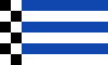
Norderney is one of the smallest German communities to fly its own flag. The small city flag has horizontal blue and white stripes and a black and white checkered area on the left side. The blue colour stands for the sea, white symbolizes the colour of the sand, and black stands for the Norderney sea sign.
Climate and recreation
Norderney has a maritime temperate climate, with generally less extreme temperatures than on the nearby mainland. Precipitation is more-or-less evenly distributed throughout the year, but autumn seems to be slightly wetter, with November being the wettest month with 87.6 millimetres (3.45 in) while February is the driest with 40.7 millimetres (1.60 in). The Island also has more sunshine hours than the mainland, with more than 1,600 hours per year. Sea temperatures are fluctuating between 3 and 7 °C (37 and 45 °F) in the winter and over 20 °C (68 °F) in the summer months. In July 2014 an record high was reached with 34.1 °C (93.4 °F) and on July 24th 2019 the record was broken again, with a new record of high of 35.4 °C (95.7 °F) – surpassing the 35 °C (95 °F) mark for the first time since measurements had started in 1947.
| Climate data for Norderney Island | |||||||||||||
|---|---|---|---|---|---|---|---|---|---|---|---|---|---|
| Month | Jan | Feb | Mar | Apr | May | Jun | Jul | Aug | Sep | Oct | Nov | Dec | Year |
| Record high °C (°F) | 11.7 (53.1) |
15.3 (59.5) |
21.8 (71.2) |
27.3 (81.1) |
30.3 (86.5) |
33.5 (92.3) |
35.4 (95.7) |
33.7 (92.7) |
30.2 (86.4) |
25.5 (77.9) |
16.6 (61.9) |
12.8 (55.0) |
35.4 (95.7) |
| Average high °C (°F) | 3.2 (37.8) |
3.6 (38.5) |
6.1 (43.0) |
9.4 (48.9) |
14.1 (57.4) |
17.0 (62.6) |
18.8 (65.8) |
19.4 (66.9) |
17.0 (62.6) |
13.0 (55.4) |
8.1 (46.6) |
4.8 (40.6) |
11.2 (52.2) |
| Daily mean °C (°F) | 1.6 (34.9) |
1.8 (35.2) |
4.0 (39.2) |
6.9 (44.4) |
11.2 (52.2) |
14.4 (57.9) |
16.3 (61.3) |
16.8 (62.2) |
14.5 (58.1) |
10.8 (51.4) |
6.3 (43.3) |
3.2 (37.8) |
9.0 (48.2) |
| Average low °C (°F) | −0.2 (31.6) |
0.0 (32.0) |
1.9 (35.4) |
4.5 (40.1) |
8.7 (47.7) |
12.1 (53.8) |
14.1 (57.4) |
14.5 (58.1) |
12.3 (54.1) |
8.7 (47.7) |
4.4 (39.9) |
1.3 (34.3) |
6.9 (44.4) |
| Record low °C (°F) | −15.5 (4.1) |
−15.3 (4.5) |
−9.6 (14.7) |
−2.8 (27.0) |
1.1 (34.0) |
5.1 (41.2) |
9.1 (48.4) |
8.9 (48.0) |
5.6 (42.1) |
−1.5 (29.3) |
−7.1 (19.2) |
−12.7 (9.1) |
−15.5 (4.1) |
| Average precipitation mm (inches) | 60.0 (2.36) |
40.7 (1.60) |
52.8 (2.08) |
41.2 (1.62) |
48.7 (1.92) |
62.7 (2.47) |
76.0 (2.99) |
72.8 (2.87) |
72.2 (2.84) |
80.2 (3.16) |
87.6 (3.45) |
74.5 (2.93) |
769.4 (30.29) |
| Mean monthly sunshine hours | 45.6 | 76.3 | 120.2 | 175.2 | 226.3 | 223.7 | 209.9 | 209.3 | 145.8 | 101.5 | 56.0 | 38.2 | 1,628 |
| Source 1: Deutscher Wetterdienst[4] | |||||||||||||
| Source 2: European Climate Assessment and Dataset[5] | |||||||||||||
There is a nudist beach just east of Norderney's popular North Beach.[6]
See also
- List of ferry boats of the East Frisian Islands
- Lager Norderney – a Nazi labour camp named after the island, on Alderney in the Channel Islands.[7]
- Norderneyer Seegatt
References
- "Bürgermeisterwahl" [Mayoral election]. Homepage of the SPD in Norderney (in German). Retrieved 23 June 2013.
- Landesamt für Statistik Niedersachsen, LSN-Online Regionaldatenbank, Tabelle 12411: Fortschreibung des Bevölkerungsstandes, Stand 31. Dezember 2018.
- "Zensusdatenbank - Ergebnisse des Zensus 2011". ergebnisse.zensus2011.de. Retrieved 2016-11-24.
- "Mittelwerte 30-jähriger Perioden" [Averages of 30-years periods] (in German). German Weather Service.
- "Millenium European Climate – Indices data". European Climate Assessment & Dataset. January 2013.
- "Nackedei auf Norderney: Das Nackt-Paradies zum Glücklichsein" [The Naked Paradise for Happiness]. BILD.de (in German). 15 August 2015. Retrieved 18 September 2016.
- Steckoll, Solomon H. (1982). The Alderney death camp. Granada. ISBN 978-0-583-13478-1.
External links
| Wikimedia Commons has media related to Norderney. |
- Official site (in German)
- Further information (in German)
- . Encyclopædia Britannica (11th ed.). 1911.

| West Frisian Islands (Netherlands) |
|  | |||||
|---|---|---|---|---|---|---|---|
| East Frisian Islands (Germany) |
| ||||||
| Heligoland Bight (Germany) | |||||||
| North Frisian Islands (Germany) |
| ||||||
| Danish Wadden Sea Islands (Denmark) |
| ||||||
Towns and municipalities in Aurich (district) | ||
|---|---|---|
Coat of arms | ||
| Authority control |
|
|---|