Simonszand
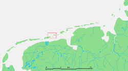
Simonszand (Dutch pronunciation: [ˈsimɔnsˌzɑnt]) is a sandbank between the West Frisian Islands of Schiermonnikoog and Rottumerplaat in the Netherlands. It is located in the municipality of Het Hogeland in the province of Groningen.
 Location of Simonszand | |
| Geography | |
|---|---|
| Coordinates | 53°31′N 6°24′E |
| Archipelago | (West) Frisian Islands |
| Adjacent bodies of water | North Sea Wadden Sea |
| Administration | |
Netherlands | |
| Province | Groningen |
| Municipality | Het Hogeland |
| Demographics | |
| Population | Uninhabited |
The sandbank was originally mapped as being an Intertidal zone in approximately 1811, but changed in later mappings to be shown as a Supratidal zone after it became larger and migrated seaward.[1]
References
- van der Velde, L. (1995). "Geologica Ultraiectina". Geologica Ultraiectina. 125-126.
External links

| West Frisian Islands (Netherlands) |
|  | |||||
|---|---|---|---|---|---|---|---|
| East Frisian Islands (Germany) |
| ||||||
| Heligoland Bight (Germany) | |||||||
| North Frisian Islands (Germany) |
| ||||||
| Danish Wadden Sea Islands (Denmark) |
| ||||||
This article is issued from Wikipedia. The text is licensed under Creative Commons - Attribution - Sharealike. Additional terms may apply for the media files.