Scharhörn
Scharhörn is an uninhabited island in the North Sea belonging to the city of Hamburg, Germany. The once most important daymark on the north sea coast, the Scharhörnbake, was maintained here by the City of Hamburg from 1440 to 1979.
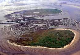 Aerial photograph of Scharhörn | |
| Geography | |
|---|---|
| Location | North Sea, Wadden Sea, Elbe mouth |
| Coordinates | 53°57′42″N 8°26′29″E |
| Area | 20 ha (49 acres) |
| Administration | |
Germany | |
| State | Hamburg |
| Borough | Hamburg-Mitte |
| Quarter | Hamburg-Neuwerk |
| Demographics | |
| Population | 0 (uninhabited) |
| Pop. density | 0/km2 (0/sq mi) |
Geography
Scharhörn lies by the mouth of the Elbe, approximately 15 km (9 mi) northwest of Cuxhaven and 6 km (4 mi) northwest of the nearby island of Neuwerk. It is a part of Zone 1 of the Hamburg Wadden Sea National Park. Aside from a nature reserve warden, the island has no permanent residents.
Together with the artificial island of Nigehörn the island lies on a large sandbank. Historically the whole area including the reef was called Scharhörn and the sandbank Scharhörnplate. After the human supported formation of the island in the 1920s and finally with the creation of Nigehörn on the same sandbank, the name Scharhörn was only used for the island. Though Scharhörn is generally flood-safe, the 6-metre-high (20 ft) banks of the island are not protected, so the island faces permanent loss of land on the western side as storm floods gradually shift the sandbank eastward.
The sandbank on which Scharhörn and Nigehörn lie is a European Union Natura 2000-designated bird sanctuary, tended to by the environmental group Verein Jordsand. The area, known as Scharhörnplate, is around 2.8 km (1.7 mi) long and 1.5 km (0.93 mi) wide with an area of approximately 500 hectares (1,200 acres). Public access to the island is forbidden, except on official tours or by prior arrangement with the warden.
History
In 1937, the island became part of the Prussian Province of Hanover as a result of the Greater Hamburg Act. The island changed hands again in 1947, when it became part of the newly-drawn state of Lower Saxony, and again in 1969, when it was returned under a treaty to the control of Hamburg for the purpose of constructing a proposed deepwater port on Scharhörn and nearby Neuwerk. The plans foresaw the construction of a 6,000 ha (15,000-acre) mound of land built from dredged sand, which was to be safe from the storm floods of the North Sea and connected to the mainland via a causeway from Scharhörn to Neuwerk to Cuxhaven.[1] The plan was never realised, plagued by protests, high costs, and low levels of public support, but nevertheless remains included in the land use plan of Hamburg.[2]
Shipwrecks
_b_549.jpg)
| Date | Vessel and description |
|---|---|
| 23 November 1815 | Lisbon was wrecked on the Scharhörn Sand. Her crew were rescued. |
| 27 September 1815 | Borsenhalle was driven ashore and later refloated. |
| 1 December 1821[3] | Carthagena, Catherine, or Catharina was driven ashore and wrecked on Scharhörn with the loss of all hands. |
| 1829 | Romulus was wrecked |
| 12 December 1829 | Lowe was driven ashore and abandoned on 28 December. |
| 24 August 1830 | Unternehmung was lost |
| 1831 | Vrow Angelina was driven ashore before 22 November. She was refloated but was subsequently wrecked on the Whitt Sand with the loss of all but one of her crew. |
| 5 April 1833 | Palm was driven ashore and damageded. Her crew were rescued. Palm was refloated on 10 April and taken in to Cuxhaven. |
| 1834 | Wharf was driven ashore |
| 21 October 1931 | Peder Most ran aground and was refloated on 24 October. |
| 29 March 1939 | Adele Ohlrogge ran aground at Scharhörn and refloated the next day. |
| 29 December 1940 | PLM-23 ran aground and was wrecked. |
| 4 January 1954 | Leros and Traunstein ran aground. Traunstein was refloated on the same day but Leros was almost lost in many damaging attempts to save the coast from a huge oil spill. She was pulled off the reef and towed into Cuxhaven on early morning Saturday January 10.[4][5] |
| 17 January 1955 | Gerda Maersk ran aground |
References
- Horst-Wolfgang Bremke: Ein Hafen im Meer. In: Die Zeit, Nr. 16/1971
- Informationen zum Flächennutzungsplan, hamburg.de
- Dates vary: 2 December 1821 or 4 December 1821
- "Welt im Bild", 81/1954, 12. January 1954 (German), Bundesarchiv
- Sieben Schicksalstage auf der „Leros“, Die Zeit, 14. Januar 1954(German)
| West Frisian Islands (Netherlands) |
|  | |||||
|---|---|---|---|---|---|---|---|
| East Frisian Islands (Germany) |
| ||||||
| Heligoland Bight (Germany) | |||||||
| North Frisian Islands (Germany) |
| ||||||
| Danish Wadden Sea Islands (Denmark) |
| ||||||
| Authority control |
|
|---|