Kachelotplate
The Kachelotplate is a sandbar in the North Sea. It lies near the German coast, west of the island of Juist. Since 2003, enough stays above high tide that it can be called an island. Grass and dunes are settling there.
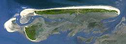 The island of Juist (in the north) with Memmert (in the south) and the Kachelotplate sandbank (in the west) | |
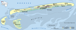 Map of the Kachelotplate west of Juist | |
| Geography | |
|---|---|
| Location | North Sea |
| Coordinates | 53°38′42″N 6°49′8″E |
| Archipelago | East Frisian Islands |
| Area | 1.72 km2 (0.66 sq mi) |
| Length | 3 km (1.9 mi) |
| Width | 1 km (0.6 mi) |
| Highest elevation | 2.5 m (8.2 ft) |
| Administration | |
Germany | |
| Demographics | |
| Population | 0 |
The new island is 2.5 kilometres long and up to 1.3 kilometres wide.
| West Frisian Islands (Netherlands) |
|  | |||||
|---|---|---|---|---|---|---|---|
| East Frisian Islands (Germany) |
| ||||||
| Heligoland Bight (Germany) | |||||||
| North Frisian Islands (Germany) |
| ||||||
| Danish Wadden Sea Islands (Denmark) |
| ||||||
This article is issued from Wikipedia. The text is licensed under Creative Commons - Attribution - Sharealike. Additional terms may apply for the media files.