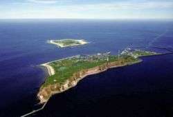
Noorderhaaks
Noorderhaaks (Dutch pronunciation: [ˌnoːrdərˈɦaːks]), also called Razende Bol (Raging Sphere in Dutch), is an uninhabited Dutch island[1] in the North Sea, a few kilometres west of the Marsdiep which separates the island of Texel from the mainland of the Netherlands. The island covers an area of around five km², although the exact area varies due to tide and the dynamic nature of the area.
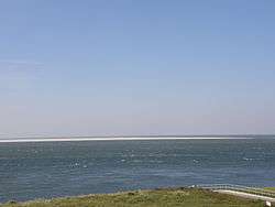 Noorderhaaks seen from the mainland | |
| Geography | |
|---|---|
| Coordinates | 52°58′30″N 4°40′50″E |
| Archipelago | (West) Frisian Islands |
| Adjacent bodies of water | North Sea |
| Administration | |
Netherlands | |
| Province | North Holland |
| Municipality | Texel |
| Demographics | |
| Population | Uninhabited |
Being relatively untouched by man, the island has become a valuable location due to its presence of several kinds of seabirds, and seals.
The island is slowly moving eastward towards the Marsdiep and the Molengat, at a pace of around 100 metres a year.[1] Noorderhaaks is probably the sixth sand bar to develop in the mouth of the Marsdiep, since it formed in the late twelfth century via a flood that occurred in 1170. The previous five have also moved towards Texel and got accreted to the island, with intervals of approximately 150 years each.[2]
The island is visited by day trippers, and is also being used as a training ground for the Royal Dutch Navy and Air Force.
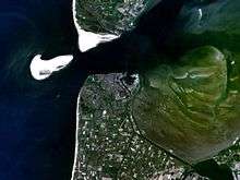 Satellite photo, taken circa 1992
.jpg) Stranded humpback whale (2012)
Stranded humpback whale (2012) Time-lapse (1984-2017)
References
- (in Dutch) "Zandplaat De Razende Bol voortaan eiland", Nederlands Dagblad, 2003.
- (in Dutch) Vos, A.D. (2012); Onderwaterarcheologie op de Rede van Texel Archived 2015-02-08 at the Wayback Machine, Nederlandse Archeologische Rapporten 041 (Rijksdienst voor het Cultureel Erfgoed, Amersfoort), p. 37-47.
External links

| West Frisian Islands (Netherlands) |
|  | |||||
|---|---|---|---|---|---|---|---|
| East Frisian Islands (Germany) |
| ||||||
| Heligoland Bight (Germany) | |||||||
| North Frisian Islands (Germany) |
| ||||||
| Danish Wadden Sea Islands (Denmark) |
| ||||||