Nong Wua So District
Nong Wua So (Thai: หนองวัวซอ, pronounced [nɔ̌ːŋ wūa̯ sɔ̄ː]) is a district (amphoe) in the western part of Udon Thani Province, northeastern Thailand.
Nong Wua So หนองวัวซอ | |
|---|---|
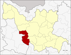 District location in Udon Thani Province | |
| Coordinates: 17°9′45″N 102°34′22″E | |
| Country | Thailand |
| Province | Udon Thani |
| Seat | Non Wai |
| Area | |
| • Total | 702.955 km2 (271.412 sq mi) |
| Population (2005) | |
| • Total | 61,658 |
| • Density | 87.7/km2 (227/sq mi) |
| Time zone | UTC+7 (ICT) |
| Postal code | 41220 |
| Geocode | 4103 |
Geography
Neighboring districts are (from the north clockwise) Kut Chap, Mueang Udon Thani, and Nong Saeng of Udon Thani Province, Khao Suan Kwang of Khon Kaen Province and Non Sang and Mueang Nongbua Lamphu of Nong Bua Lamphu Province.
History
The district was established as a minor district (king amphoe) on 16 April 1971, when it was split off from Mueang Udon Thani District.[1] It was upgraded to a full district on 1 April 1974.[2]
Administration
The district is divided into eight sub-districts (tambons), which are further subdivided into 78 villages (mubans). There are two townships (thesaban tambon). Nong Wua So covers parts of tambons Nong Wua So and Mak Ya; and Nong O Non Wai covers parts of tambons Nong O and Non Wai. There are a further seven tambon administrative organizations (TAO).
| No. | Name | Thai name | Villages | Pop. | |
|---|---|---|---|---|---|
| 1. | Mak Ya | หมากหญ้า | 12 | 8,077 | |
| 2. | Nong O | หนองอ้อ | 11 | 9,055 | |
| 3. | Up Mung | อูบมุง | 10 | 8,435 | |
| 4. | Kut Mak Fai | กุดหมากไฟ | 11 | 7,984 | |
| 5. | Nam Phon | น้ำพ่น | 8 | 6,789 | |
| 6. | Nong Bua Ban | หนองบัวบาน | 9 | 6,077 | |
| 7. | Non Wai | โนนหวาย | 9 | 7,738 | |
| 8. | Nong Wua So | หนองวัวซอ | 8 | 7,503 |
References
- ประกาศกระทรวงมหาดไทย เรื่อง แบ่งท้องที่อำเภอเมืองอุดรธานี จังหวัดอุดรธานี ตั้งเป็นกิ่งอำเภอหนองวัวซอ (PDF). Royal Gazette (in Thai). 88 (42 ง): 1330. April 20, 1971.
- พระราชกฤษฎีกาตั้งอำเภอเขาวง อำเภอเชียงม่วน อำเภอดอนตาล อำเภอชาติตระการ อำเภอภูเรือ อำเภอเคียนซา อำเภอน้ำโสม อำเภอหนองวัวซอ และอำเภอน้ำยืน พ.ศ. ๒๕๑๗ (PDF). Royal Gazette (in Thai). 91 (54 ก special issue): 30–33. March 28, 1974.