Trường Sa District
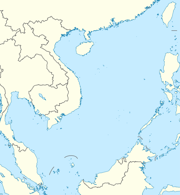
Trường Sa is an island district of Khánh Hòa Province in the South Central Coast region of Vietnam.[2] It was established on the basis of the Spratly Islands, which is also claimed wholly or in part by Brunei, China, Malaysia, the Philippines and Taiwan. According to the 2009 census, the district has a population of 195 people.[3]
Trường Sa District Huyện đảo Trường Sa | |
|---|---|
| Trường Sa Island District | |
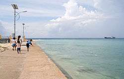 Children playing on the beach of Trường Sa | |
 Trường Sa District | |
| Coordinates: 8°38′30″N 111°55′55″E | |
| Country | |
| Region | South Central Coast |
| Province | Khánh Hòa |
| Government | |
| • Chairman of People's Committee | Nguyễn Viết Thuân[1] |
| Area | |
| • Total | 192 sq mi (496 km2) |
| Population (2009) | |
| • Total | 195 |
| • Density | 1.0/sq mi (0.39/km2) |
| Time zone | UTC+7 (Indochina Time) |
| Area code(s) | 58 |
Geography
Trường Sa District was established on the basis of small coral islands/cays, reefs and banks of the Spratly Islands which are 248 nautical miles (459 km; 285 mi) south east of Cam Ranh. As the islands contain a large number of scattered geographic entities, the district is divided into eight clusters including Song Tử, Thị Tứ, Loại Ta, Nam Yết, Sinh Tồn, Trường Sa, Thám Hiểm and Bình Nguyên by Vietnam.[4]
Administrative history in the 20th century
- By the early 1930s, France had claimed the Spratly Islands. On 21 December 1933, Cochinchina's governor Jean-Félix Krautheimer signed Decree No. 4702-CP annexing Spratly Island, Amboyna Cay, Itu Aba Island, Northeast Cay, Southwest Cay, Thitu Island, Loaita Island and subsidiary islands into Bà Rịa Province.[5]
- On 22 October 1956, Republic of Vietnam's President Ngô Đình Diệm signed Decree No. 143-NV renaming provinces of South Vietnam. According to this decree, Bà Rịa - Vũng Tàu was renamed to Phước Tuy Province under which the Spratly Islands was administered.[4]
- On 6 September 1973, the Republic of Vietnam's Ministry of the Interior signed Decree No. 420-BNV/HCĐP/26 merging Spratly Island, Amboyna Cay, Itu Aba Island, Northeast Cay, Southwest Cay, Loaita Island, Thitu Island, Namyit Island, Sin Cowe Island and the surrounding islands into Phước Hải Commune, Đất Đỏ District, Phước Tuy Province.[6]
- On 9 December 1982, the Council of Ministers of the Socialist Republic of Vietnam issued Decision No. 193/HĐBT establishing Trường Sa District as an administrative unit of Đồng Nai Province.[7] On December 28, 1982, The Seventh National Assembly decided to incorporate Trường Sa District into Phú Khánh Province.[8]
- On 1 July 1989, the National Assembly split Phú Khánh Province into Phú Yên Province and Khánh Hòa Province. Trường Sa District has been under the direct administration of Khánh Hòa since then.
Administration
According to Decree No. 65/2007/NĐ-CP of 11 April 2007 issued by the Government of the Socialist Republic of Vietnam, Trường Sa District has three administrative units including one commune-level town (Trường Sa) and two rural communes (Song Tử Tây and Sinh Tồn).
- Trường Sa Town was established on the basis of Trường Sa Island (Spratly Island) and surrounding islands, reefs and banks.
- Song Tử Tây Commune was established on the basis of Song Tử Tây island (Southwest Cay) and surrounding islands, reefs and banks.
- Sinh Tồn Commune was established on the basis of Sinh Tồn Island (Sin Cowe Island) and surrounding islands, reefs and banks.
In reality, Trường Sa District is effectively administering only 21 islets and reefs of the Spratly Islands:
| Cluster | Coral islands/cays | Reefs | Map |
|---|---|---|---|
| Song Tử | Southwest Cay (đảo Song Tử Tây) | South Reef (đá Nam) | |
| Thị Tứ | - | - | |
| Loại Ta | - | - | |
| Nam Yết | Namyit Island (đảo Nam Yết), Sand Cay (đảo Sơn Ca) | Discovery Great Reef (đá Lớn), Petley Reef (đá Núi Thị) | |
| Sinh Tồn | Sin Cowe Island (đảo Sinh Tồn), Grierson Reef (đảo Sinh Tồn Đông)[Notes 1] | Collins Reef/Johnson North Reef (đá Cô Lin), Lansdowne Reef (đá Len Đao) | |
| Trường Sa | Spratly Island (đảo Trường Sa), Pearson Reef (đảo Phan Vinh),[Notes 2] Central London Reef (đảo Trường Sa Đông)[Notes 3] | East London Reef (đá Đông), Ladd Reef (đá Lát), Cornwallis South Reef (đá Núi Le), West London Reef (đá Tây), Pigeon Reef/Tennent Reef (đá Tiên Nữ), Alison Reef (đá Tốc Tan) | |
| Thám Hiểm | Amboyna Cay (đảo An Bang) | Barque Canada Reef (đá Thuyền Chài) | |
| Bình Nguyên | - | - |
See also
Notes
References
- (in Vietnamese) Chủ tịch huyện đảo Trường Sa vào bệnh viện chăm vợ con
- (in Vietnamese) "Nghị định số 65/2007/NĐ-CP". Ministry of Justice's Portal (Vietnam). Archived from the original on June 22, 2013. Retrieved December 20, 2012.
- "The 2009 Vietnam Population and Housing census: Completed results". General Statistics Office of Vietnam. Retrieved December 20, 2012.
- (in Vietnamese) Nguyễn, Nhã (2002). Quá trình xác lập chủ quyền của Việt Nam tại quần đảo Hoàng Sa và Trường Sa [The Process of Establishing the Sovereignty of Vietnam over the Hoang Sa and Trường Sa Islands] (Thesis). University of Social Science and Humanities (Vietnam National University, Ho Chi Minh City). p. 109.
- "Truong Sa archipelago belongs to Ba Ria province (1933)". Website on Viet Nam's sovereign boundaries, The National Boundary Commission, Ministry of Foreign Affairs (Vietnam). December 21, 1933. Archived from the original on March 17, 2012. Retrieved December 20, 2012.
- "A number historical and juridical documents on Vietnam's sovereignty over the Trường Sa and Hoang Sa archipelagoes- Part 3". Authority of Foreign Information Service, Ministry of Information and Communications (Vietnam). October 21, 2011. Archived from the original on November 27, 2012. Retrieved December 20, 2012.
- (in Vietnamese) "Quyết định của Hội đồng Bộ trưởng số 193/HĐBT ngày 9 tháng 12 năm 1982 về việc thành lập huyện Trường Sa thuộc tỉnh Đồng Nai". Dong Nai Province's Electronic Portal (Vietnam). Retrieved December 20, 2012.
- (in Vietnamese) "Nghị quyết của Quốc hội Nước CHXHCN Việt Nam ngày 28 tháng 12 năm 1982 về việc sáp nhập huyện Trường Sa thuộc tỉnh Đồng Nai vào tỉnh Phú Khánh". Ministry of Justice's Portal (Vietnam). Retrieved December 20, 2012.
| Da Nang city | 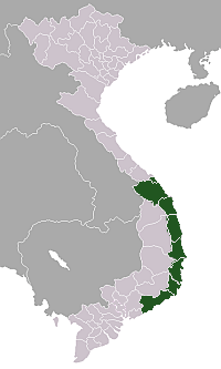 | |
|---|---|---|
| Bình Định Province | ||
| Bình Thuận Province | ||
| Khánh Hòa Province |
| |
| Ninh Thuận Province | ||
| Phú Yên Province | ||
| Quảng Nam Province | ||
| Quảng Ngãi Province | ||
※ denotes provincial seat. / § Sovereignty over Hoàng Sa & Trường Sa archipelagoes is disputed as of 25 June 2020. | ||