National Register of Historic Places listings in Nicholas County, West Virginia
This is a list of the National Register of Historic Places listings in Nicholas County, West Virginia.

This is intended to be a complete list of the properties and districts on the National Register of Historic Places in Nicholas County, West Virginia, United States. The locations of National Register properties and districts for which the latitude and longitude coordinates are included below, may be seen in a Google map.[1]
There are 13 properties and districts listed on the National Register in the county.
- This National Park Service list is complete through NPS recent listings posted June 19, 2020.[2]
Barbour - Berkeley - Boone - Braxton - Brooke - Cabell - Calhoun - Clay - Doddridge - Fayette - Gilmer - Grant - Greenbrier - Hampshire - Hancock - Hardy - Harrison - Jackson - Jefferson - Kanawha - Lewis - Lincoln - Logan - Marion - Marshall - Mason - McDowell - Mercer - Mineral - Mingo - Monongalia - Monroe - Morgan - Nicholas - Ohio - Pendleton - Pleasants - Pocahontas - Preston - Putnam - Raleigh - Randolph - Ritchie - Roane - Summers - Taylor - Tucker - Tyler - Upshur - Wayne - Webster - Wetzel - Wirt - Wood - Wyoming |
Current listings
| [3] | Name on the Register | Image | Date listed[4] | Location | City or town | Description |
|---|---|---|---|---|---|---|
| 1 | Beaver Mill | July 25, 2001 (#01000776) |
West Webster Rd. 38°19′44″N 80°39′55″W |
Craigsville | ||
| 2 | Brock Hotel | 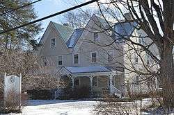 Brock Hotel |
July 9, 1993 (#93000615) |
1400 Webster Rd. 38°17′00″N 80°50′41″W |
Summersville | |
| 3 | Dr. Flavius Brown House | January 7, 2003 (#02001053) |
Old Wilderness Rd. 38°16′38″N 80°50′59″W |
Summersville | ||
| 4 | James B. Carden House | August 2, 2001 (#01000773) |
1082 Country Rd. 38°17′11″N 80°57′04″W |
Summersville | ||
| 5 | Carnifex Ferry State Park | 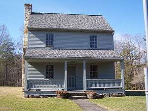 Carnifex Ferry State Park |
July 24, 1974 (#74002018) |
South of Kesslers Cross Lanes off WV 129 38°12′24″N 80°56′14″W |
Kesslers Cross Lanes | |
| 6 | Downtown Richwood Historic District |  Downtown Richwood Historic District |
July 25, 2001 (#01000778) |
Roughly including portions of Main St., Oakford Ave., and Commercial St. 38°13′28″N 80°32′03″W |
Richwood | |
| 7 | Capt. John Halstead Farm | December 15, 1998 (#98001475) |
Whitewater Rd. (County Route 9) 38°20′05″N 80°56′21″W |
Kesslers Cross Lanes | ||
| 8 | Martin Hamilton House | November 22, 1999 (#99001403) |
WV 39 38°17′14″N 80°51′37″W |
Summersville | ||
| 9 | Lockwood Historic District | December 16, 1998 (#98001468) |
Roughly along WV 39 38°15′27″N 81°01′42″W |
Lockwood | ||
| 10 | Mason-Drennen House | December 15, 1998 (#98001474) |
Junction of West Virginia Routes 39 and WV 129 38°16′02″N 80°59′32″W |
Drennen | ||
| 11 | Nicholas County Bank |  Nicholas County Bank |
November 2, 2000 (#00001314) |
800 Main St. 38°16′51″N 80°51′03″W |
Summersville | |
| 12 | Nicholas County Courthouse | 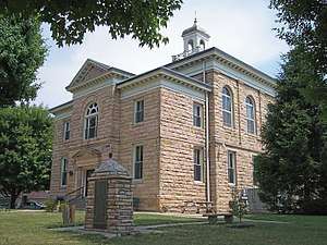 Nicholas County Courthouse |
August 16, 1991 (#91001014) |
700 Main St. 38°15′45″N 80°51′05″W |
Summersville | |
| 13 | Nicholas County High School | 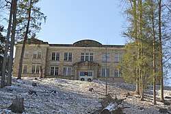 Nicholas County High School |
March 27, 1989 (#89000185) |
Main St. 38°16′51″N 80°51′28″W |
Summersville | This is the former high school building; the current property is not listed. |
See also
| Wikimedia Commons has media related to National Register of Historic Places in Nicholas County, West Virginia. |
References
- The latitude and longitude information provided in this table was derived originally from the National Register Information System, which has been found to be fairly accurate for about 99% of listings. Some locations in this table may have been corrected to current GPS standards.
- "National Register of Historic Places: Weekly List Actions". National Park Service, United States Department of the Interior. Retrieved on June 19, 2020.
- Numbers represent an ordering by significant words. Various colorings, defined here, differentiate National Historic Landmarks and historic districts from other NRHP buildings, structures, sites or objects.
- The eight-digit number below each date is the number assigned to each location in the National Register Information System database, which can be viewed by clicking the number.
| Topics | ||
|---|---|---|
| Lists by county |
| |
| Other lists | ||
| ||
Municipalities and communities of Nicholas County, West Virginia, United States | ||
|---|---|---|
| City | Map of West Virginia highlighting Nicholas County | |
| CDPs | ||
| Unincorporated communities |
| |
| Ghost towns | ||
| Footnotes | ‡This populated place also has portions in an adjacent county or counties | |