National Register of Historic Places listings in Monroe County, West Virginia
This is a list of the National Register of Historic Places listings in Monroe County, West Virginia.
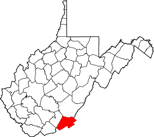
This is intended to be a complete list of the properties and districts on the National Register of Historic Places in Monroe County, West Virginia, United States. The locations of National Register properties and districts for which the latitude and longitude coordinates are included below, may be seen in a Google map.[1]
There are 24 properties and districts listed on the National Register in the county.
- This National Park Service list is complete through NPS recent listings posted June 19, 2020.[2]
Barbour - Berkeley - Boone - Braxton - Brooke - Cabell - Calhoun - Clay - Doddridge - Fayette - Gilmer - Grant - Greenbrier - Hampshire - Hancock - Hardy - Harrison - Jackson - Jefferson - Kanawha - Lewis - Lincoln - Logan - Marion - Marshall - Mason - McDowell - Mercer - Mineral - Mingo - Monongalia - Monroe - Morgan - Nicholas - Ohio - Pendleton - Pleasants - Pocahontas - Preston - Putnam - Raleigh - Randolph - Ritchie - Roane - Summers - Taylor - Tucker - Tyler - Upshur - Wayne - Webster - Wetzel - Wirt - Wood - Wyoming |
Current listings
| [3] | Name on the Register[4] | Image | Date listed[5] | Location | City or town | Description |
|---|---|---|---|---|---|---|
| 1 | Alderson Bridge | 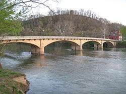 Alderson Bridge |
December 4, 1991 (#91001730) |
Monroe St. across the Greenbrier River 37°43′29″N 80°38′36″W |
Alderson | |
| 2 | Alderson Historic District | 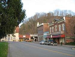 Alderson Historic District |
November 12, 1993 (#93001231) |
Roughly along Monroe St., Riverview Dr., Railroad Ave. and adjacent streets 37°43′29″N 80°38′32″W |
Alderson | |
| 3 | Byrnside-Beirne-Johnson House | 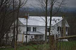 Byrnside-Beirne-Johnson House |
December 2, 1993 (#93001358) |
County Route 13 south of Union 37°34′30″N 80°32′19″W |
Union | |
| 4 | Clarence Campbell House | 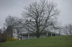 Clarence Campbell House |
July 21, 1995 (#95000872) |
West Virginia Route 3 37°35′24″N 80°31′26″W |
Union | |
| 5 | William Gaston Caperton, Jr., House | 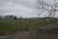 William Gaston Caperton, Jr., House |
November 21, 1991 (#91001733) |
West Virginia Route 3 east of Union 37°35′33″N 80°30′47″W |
Union | |
| 6 | Cook's Mill | February 6, 1989 (#88001857) |
County Route 2 37°32′42″N 80°41′14″W |
Greenville | ||
| 7 | Brig. Gen. John Echols House | 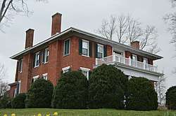 Brig. Gen. John Echols House |
June 27, 1985 (#85001415) |
Elmwood and 2nd St. N. 37°35′33″N 80°32′32″W |
Union | |
| 8 | Elmwood | 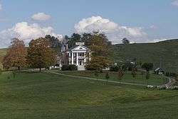 Elmwood |
May 13, 1976 (#76001942) |
North of Union off U.S. Route 219 37°35′44″N 80°32′23″W |
Union | |
| 9 | Wallace Estill, Sr., House | April 9, 1984 (#84003634) |
WV 122 37°31′34″N 80°37′43″W |
Union | ||
| 10 | Indian Creek Covered Bridge | 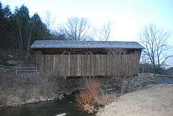 Indian Creek Covered Bridge |
April 1, 1975 (#75001895) |
1.5 mi (2.4 km) south of Salt Sulphur Springs on U.S. Route 219 37°32′50″N 80°34′22″W |
Salt Sulphur Springs | |
| 11 | Laurel Creek Covered Bridge | 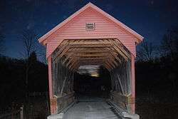 Laurel Creek Covered Bridge |
June 4, 1981 (#81000605) |
County Route 23/4 west of County Route 219/11 37°33′40″N 80°37′36″W |
Lillydale | |
| 12 | Lynnside Historic District | 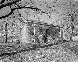 Lynnside Historic District |
April 26, 1991 (#91000452) |
Junction of WV 3 and Cove Creek Road 37°38′12″N 80°14′46″W |
Sweet Springs | |
| 13 | McNeer House |  McNeer House |
April 26, 1991 (#91000453) |
U.S. Route 219 at Gin Run 37°34′25″N 80°34′03″W |
Salt Sulphur Springs | |
| 14 | Miller-Pence Farm | September 28, 2006 (#06000899) |
8 mi (13 km) west of the junction of U.S. Route 219 and WV 122 37°31′33″N 80°38′30″W |
Greenville | ||
| 15 | Nickell Homestead and Mill | December 15, 1998 (#98001472) |
McClung Rd. 37°41′26″N 80°29′58″W |
Ronceverte | ||
| 16 | Old Sweet Springs | 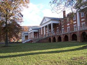 Old Sweet Springs |
January 26, 1970 (#70000659) |
WV 3 37°37′43″N 80°14′29″W |
Sweet Springs | |
| 17 | Pickaway Rural Historic District |  Pickaway Rural Historic District |
March 5, 1999 (#99000290) |
Roughly between U.S. Route 219 and WV 3 37°38′05″N 80°30′41″W |
Union | |
| 18 | Reed's Mill | April 9, 1993 (#93000226) |
County Route 219/1 37°40′02″N 80°27′23″W |
Second Creek | ||
| 19 | Rehoboth Church | 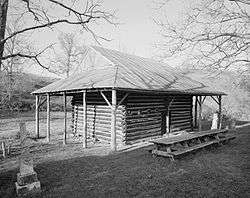 Rehoboth Church |
December 31, 1974 (#74002016) |
2 mi (3.2 km) east of Union off WV 3 37°35′24″N 80°30′24″W |
Union | |
| 20 | Salt Sulphur Springs Historic District | 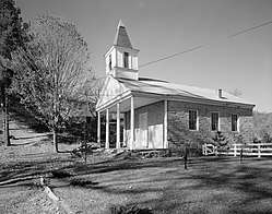 Salt Sulphur Springs Historic District |
October 31, 1985 (#85003412) |
U.S. Route 219 37°34′12″N 80°34′09″W |
Union | |
| 21 | Spring Valley Farm | December 30, 1974 (#74002017) |
Northeast of Union on U.S. Route 219 37°41′01″N 80°27′30″W |
Union | ||
| 22 | Sunset Hill | 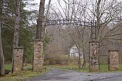 Sunset Hill |
July 14, 2000 (#00000777) |
Flat Mountain Rd. 37°43′14″N 80°38′15″W |
Alderson | |
| 23 | Union Historic District |  Union Historic District |
December 6, 1990 (#90001844) |
Roughly along Main, Dunlap, Pump, and Elmwood Sts. north from Royal Oak Field, including Paradise and Monument Fields 37°35′35″N 80°32′25″W |
Union | |
| 24 | Walnut Grove | 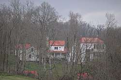 Walnut Grove |
August 22, 1977 (#77001378) |
North of Union on U.S. Route 219 37°36′09″N 80°32′29″W |
Union |
See also
| Wikimedia Commons has media related to National Register of Historic Places in Monroe County, West Virginia. |
References
- The latitude and longitude information provided in this table was derived originally from the National Register Information System, which has been found to be fairly accurate for about 99% of listings. Some locations in this table may have been corrected to current GPS standards.
- "National Register of Historic Places: Weekly List Actions". National Park Service, United States Department of the Interior. Retrieved on June 19, 2020.
- Numbers represent an ordering by significant words. Various colorings, defined here, differentiate National Historic Landmarks and historic districts from other NRHP buildings, structures, sites or objects.
- "National Register Information System". National Register of Historic Places. National Park Service. April 24, 2008.
- The eight-digit number below each date is the number assigned to each location in the National Register Information System database, which can be viewed by clicking the number.
| Topics | ||
|---|---|---|
| Lists by county |
| |
| Other lists | ||
| ||
Municipalities and communities of Monroe County, West Virginia, United States | ||
|---|---|---|
| Towns | Monroe County map | |
| Unincorporated communities |
| |
| Ghost town | ||
| Footnotes | ‡This populated place also has portions in an adjacent county or counties | |