National Register of Historic Places listings in Preston County, West Virginia
This is a list of the National Register of Historic Places listings in Preston County, West Virginia. This is intended to be a complete list of the properties and districts on the National Register of Historic Places in Preston County, West Virginia. The locations of National Register properties and districts for which the latitude and longitude coordinates are included below, may be seen in a Google map.[1]
There are 21 properties and districts listed on the National Register in the county.
- This National Park Service list is complete through NPS recent listings posted June 19, 2020.[2]
Barbour - Berkeley - Boone - Braxton - Brooke - Cabell - Calhoun - Clay - Doddridge - Fayette - Gilmer - Grant - Greenbrier - Hampshire - Hancock - Hardy - Harrison - Jackson - Jefferson - Kanawha - Lewis - Lincoln - Logan - Marion - Marshall - Mason - McDowell - Mercer - Mineral - Mingo - Monongalia - Monroe - Morgan - Nicholas - Ohio - Pendleton - Pleasants - Pocahontas - Preston - Putnam - Raleigh - Randolph - Ritchie - Roane - Summers - Taylor - Tucker - Tyler - Upshur - Wayne - Webster - Wetzel - Wirt - Wood - Wyoming |
Current listings
| [3] | Name on the Register[4] | Image | Date listed[5] | Location | City or town | Description |
|---|---|---|---|---|---|---|
| 1 | Arthurdale Historic District |  Arthurdale Historic District |
February 1, 1989 (#88001862) |
East and west of WV 92 39°29′34″N 79°49′01″W |
Arthurdale | |
| 2 | Brookside Historic District | .jpg) Brookside Historic District |
May 8, 2013 (#13000264) |
George Washington Hwy. near Cathedral State Park 39°19′33″N 79°32′06″W |
Aurora | |
| 3 | Col. Thomas Brown House | 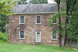 Col. Thomas Brown House |
March 17, 1994 (#94000212) |
County Route 92/4 south of Reedsville 39°28′31″N 79°48′42″W |
Reedsville | |
| 4 | Coopers Rock State Forest Superintendent's House and Garage | 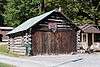 Coopers Rock State Forest Superintendent's House and Garage |
May 15, 1991 (#91000546) |
Off Interstate 68 8 mi (13 km) east of Morgantown 39°39′38″N 79°46′53″W |
Morgantown | |
| 5 | Downtown Rowlesburg Historic District | 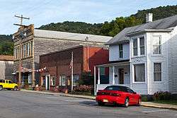 Downtown Rowlesburg Historic District |
November 30, 2005 (#05001350) |
Buffalo St., Church St., portions of Main St., Poplar St., Railroad Alley and Railroad St. 39°20′50″N 79°40′14″W |
Rowlesburg | |
| 6 | Elkins Coal and Coke Company Historic District | .jpg) Elkins Coal and Coke Company Historic District |
July 1, 1983 (#83003249) |
Off WV 7 39°32′42″N 79°48′36″W |
Bretz | |
| 7 | Fairfax Stone Site | 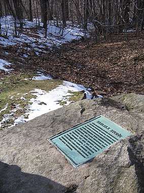 Fairfax Stone Site |
January 26, 1970 (#70000653) |
North of William at corner of Grant, Preston, and Tucker counties 39°11′42″N 79°29′16″W |
Redhouse | |
| 8 | Gaymont | .jpg) Gaymont |
April 14, 1992 (#92000351) |
U.S. Route 50 west of junction with WV 24 39°19′31″N 79°32′08″W |
Aurora | |
| 9 | A.W. Gribble Farm | 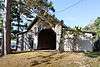 A.W. Gribble Farm |
December 30, 2009 (#09001192) |
Loop Rd. 39°37′35″N 79°46′03″W |
Pisgah | |
| 10 | Hagans Homestead | 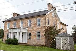 Hagans Homestead |
July 14, 1993 (#93000617) |
WV 26, 1 mile north of junction with Interstate 68 (Exit 23) 39°39′56″N 79°37′22″W |
Brandonville | |
| 11 | Indian Rocks Dining Hall | 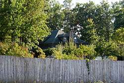 Indian Rocks Dining Hall |
January 8, 2003 (#02001688) |
WV 7, 1 mile east of Reedsville 39°30′37″N 79°45′55″W |
Reedsville | |
| 12 | Kingwood Historic District |  Kingwood Historic District |
July 15, 1994 (#94000723) |
Roughly bounded by Tunnelton, Main, Sigler, High, and Price Sts. and Brown Ave. 39°28′13″N 79°41′14″W |
Kingwood | |
| 13 | James S. Lakin House | 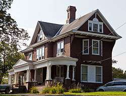 James S. Lakin House |
January 9, 1997 (#96001573) |
102 Aurora Ave. 39°26′37″N 79°32′51″W |
Terra Alta | |
| 14 | James Clark McGrew House |  James Clark McGrew House |
July 9, 1993 (#93000618) |
109 E. Main St. 39°28′20″N 79°41′11″W |
Kingwood | |
| 15 | Old Hemlock | 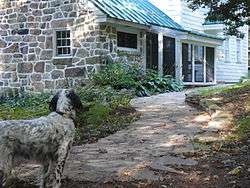 Old Hemlock |
December 16, 2014 (#14001061) |
17098 Brandonville Pike 39°38′54″N 79°37′02″W |
Bruceton Mills | |
| 16 | Ralphsnyder Decagonal Barn | 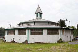 Ralphsnyder Decagonal Barn |
December 2, 1985 (#85003111) |
County Route 52/2 39°33′10″N 79°45′47″W |
Masontown | |
| 17 | Reckart Mill | 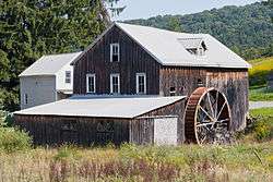 Reckart Mill |
June 3, 1980 (#80004039) |
West of Cranesville at junction of WV 28 and County Route 47/2 39°33′12″N 79°31′41″W |
Cranesville | |
| 18 | Red Horse Tavern | 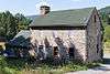 Red Horse Tavern |
July 2, 1973 (#73001923) |
1 mile east of Aurora on U.S. Route 50 39°19′35″N 79°31′54″W |
Aurora and Brookside | Boundaries increased on May 4, 1989 |
| 19 | Terra Alta Bank | 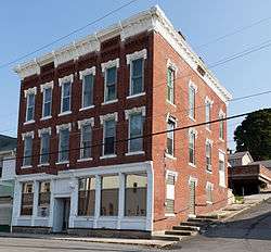 Terra Alta Bank |
July 9, 1997 (#97000786) |
109 E. Washington St. 39°26′42″N 79°32′45″W |
Terra Alta | |
| 20 | Tunnelton Railroad Depot | 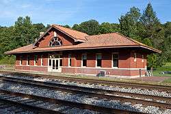 Tunnelton Railroad Depot |
May 2, 1996 (#96000437) |
Boswell St., north of the junction of Boswell and South Sts. 39°23′37″N 79°44′45″W |
Tunnelton | |
| 21 | Virginia Furnace | 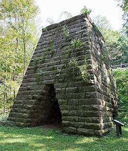 Virginia Furnace |
July 1, 1999 (#99000790) |
WV 26, along Muddy Creek 39°31′45″N 79°38′00″W |
Albright |
See also
| Wikimedia Commons has media related to National Register of Historic Places in Preston County, West Virginia. |
References
- The latitude and longitude information provided in this table was derived originally from the National Register Information System, which has been found to be fairly accurate for about 99% of listings. Some locations in this table may have been corrected to current GPS standards.
- "National Register of Historic Places: Weekly List Actions". National Park Service, United States Department of the Interior. Retrieved on June 19, 2020.
- Numbers represent an ordering by significant words. Various colorings, defined here, differentiate National Historic Landmarks and historic districts from other NRHP buildings, structures, sites or objects.
- "National Register Information System". National Register of Historic Places. National Park Service. April 24, 2008.
- The eight-digit number below each date is the number assigned to each location in the National Register Information System database, which can be viewed by clicking the number.
| Topics | ||
|---|---|---|
| Lists by county |
| |
| Other lists | ||
| ||
Municipalities and communities of Preston County, West Virginia, United States | ||
|---|---|---|
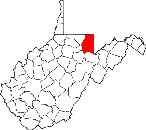
| City | Map of West Virginia highlighting Preston County | |
| Towns | ||
| CDP | ||
| Unincorporated communities |
| |
| Footnotes | ‡This populated place also has portions in an adjacent county or counties | |