National Register of Historic Places listings in Cibola County, New Mexico
This is a list of the National Register of Historic Places listings in Cibola County, New Mexico.
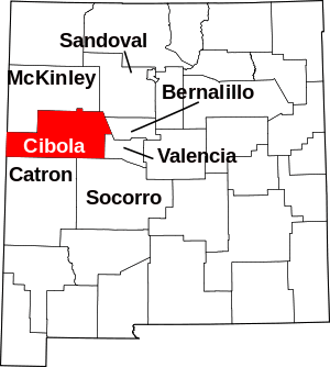
Location of Cibola County in New Mexico
This is intended to be a complete list of the properties and districts on the National Register of Historic Places in Cibola County, New Mexico, United States. Latitude and longitude coordinates are provided for many National Register properties and districts; these locations may be seen together in a map.[1]
There are 18 properties and districts listed on the National Register in the county, including 4 National Historic Landmarks. All of the places within the county listed on the National Register, with the exception of Acoma, Hawikuh, and San Estevan Del Rey Mission Church, are also recorded on the State Register of Cultural Properties.
- This National Park Service list is complete through NPS recent listings posted June 19, 2020.[2]
| Bernalillo – Catron – Chaves – Cibola – Colfax – Curry – De Baca – Doña Ana – Eddy – Grant – Guadalupe – Harding – Hidalgo – Lea – Lincoln – Los Alamos – Luna – McKinley – Mora – Otero – Quay – Rio Arriba – Roosevelt – San Juan – San Miguel – Sandoval – Santa Fe – Sierra – Socorro – Taos – Torrance – Union – Valencia |
Current listings
| [3] | Name on the Register[4] | Image | Date listed[5] | Location | City or town | Description |
|---|---|---|---|---|---|---|
| 1 | Acoma |  Acoma |
October 15, 1966 (#66000500) |
Indian Service Road 38 34°53′47″N 107°34′55″W |
Casa Blanca | |
| 2 | Acoma Curio Shop | 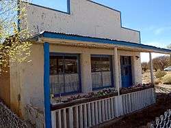 Acoma Curio Shop |
October 7, 2009 (#09000817) |
1090 State Road 124 35°04′56″N 107°35′54″W |
San Fidel | |
| 3 | Bowlin's Old Crater Trading Post | 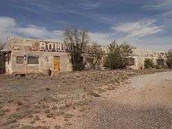 Bowlin's Old Crater Trading Post |
March 21, 2006 (#06000150) |
7650 Frontage Rd. 35°17′03″N 107°59′11″W |
Bluewater | |
| 4 | Candelaria Pueblo | 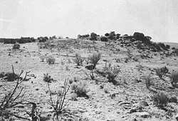 Candelaria Pueblo |
March 10, 1983 (#83001619) |
El Malpais National Monument |
Grants | |
| 5 | Charley's Automotive Service |  Charley's Automotive Service |
October 4, 2017 (#100001715) |
1310 W. Santa Fe Ave. 35°09′19″N 107°51′50″W |
Grants | |
| 6 | Dittert Site | 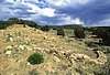 Dittert Site |
August 22, 1977 (#77000931) |
El Malpais National Conservation Area 34°39′33″N 107°58′20″W |
Grants | |
| 7 | El Morro National Monument |  El Morro National Monument |
October 15, 1966 (#66000043) |
State Road 53 35°02′18″N 108°21′12″W |
El Morro | |
| 8 | Grants-Milan Flight Service Station | 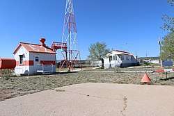 Grants-Milan Flight Service Station |
August 3, 2015 (#15000492) |
1116 N. Dale Carnutte Rd. 35°09′59″N 107°53′51″W |
Grants | |
| 9 | Hawikuh | 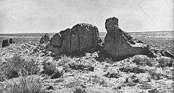 Hawikuh |
October 15, 1966 (#66000502) |
12 miles southwest of Zuni on the Zuni Indian Reservation 34°56′25″N 108°59′57″W |
Zuni Pueblo | |
| 10 | Laguna Pueblo | 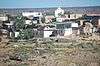 Laguna Pueblo |
June 19, 1973 (#73001154) |
E junction of I-40 and State Road 124 35°01′08″N 107°23′04″W |
Albuquerque | |
| 11 | Route 66 Rural Historic District: Laguna to McCartys | 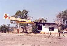 Route 66 Rural Historic District: Laguna to McCartys |
January 13, 1994 (#93001466) |
State Road 124 between interchanges on Interstate 40 35°03′43″N 107°29′53″W |
Cubero | |
| 12 | Route 66, State Maintained from McCartys to Grants |  Route 66, State Maintained from McCartys to Grants |
November 19, 1997 (#97001398) |
Former U.S. Route 66 from east of McCartys to east of Grants 35°05′29″N 107°44′15″W |
Grants | |
| 13 | Route 66, State maintained from Milan to Continental Divide | 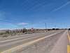 Route 66, State maintained from Milan to Continental Divide |
November 19, 1997 (#97001394) |
Along former U.S. Route 66 from west of Milan to the Continental Divide 35°22′37″N 108°06′48″W |
Continental Divide | |
| 14 | San Estevan del Rey Mission Church | 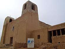 San Estevan del Rey Mission Church |
April 15, 1970 (#70000417) |
State Road 23 34°53′50″N 107°34′57″W |
Acoma | |
| 15 | San Jose de la Laguna Mission and Convento | 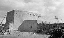 San Jose de la Laguna Mission and Convento |
January 29, 1973 (#73001155) |
Address unknown 35°02′05″N 107°23′17″W |
Laguna Pueblo | |
| 16 | San Mateo Archeological Site | May 17, 1979 (#79001563) |
Address Restricted |
San Mateo | ||
| 17 | Village of Encinal Day School | August 8, 1980 (#80002576) |
NW of Encinal 35°07′14″N 107°27′48″W |
Encinal | ||
| 18 | Zuni-Cibola Complex | December 2, 1974 (#74002267) |
Address Restricted |
Zuni Pueblo | Extends into McKinley County |
See also
| Wikimedia Commons has media related to National Register of Historic Places in Cibola County, New Mexico. |
References
- The latitude and longitude information provided in this table was derived originally from the National Register Information System, which has been found to be fairly accurate for about 99% of listings. Some locations in this table may have been corrected to current GPS standards.
- "National Register of Historic Places: Weekly List Actions". National Park Service, United States Department of the Interior. Retrieved on June 19, 2020.
- Numbers represent an ordering by significant words. Various colorings, defined here, differentiate National Historic Landmarks and historic districts from other NRHP buildings, structures, sites or objects.
- "National Register Information System". National Register of Historic Places. National Park Service. July 9, 2010.
- The eight-digit number below each date is the number assigned to each location in the National Register Information System database, which can be viewed by clicking the number.
| Topics | |
|---|---|
| Lists by state |
|
| Lists by insular areas | |
| Lists by associated state | |
| Other areas | |
| Related | |
| |
Municipalities and communities of Cibola County, New Mexico, United States | ||
|---|---|---|
| City | Map of New Mexico highlighting Cibola County | |
| Village | ||
| CDPs | ||
| Unincorporated communities | ||
| Indian reservations | ||
| Footnotes | ‡This populated place also has portions in an adjacent county or counties | |
This article is issued from Wikipedia. The text is licensed under Creative Commons - Attribution - Sharealike. Additional terms may apply for the media files.