National Register of Historic Places listings in Colfax County, New Mexico
This is a list of the National Register of Historic Places listings in Colfax County, New Mexico.
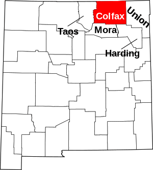
Location of Colfax County in New Mexico
This is intended to be a complete list of the properties and districts on the National Register of Historic Places in Colfax County, New Mexico, United States. Latitude and longitude coordinates are provided for many National Register properties and districts; these locations may be seen together in a map.[1]
There are 30 properties and districts listed on the National Register in the county, including 2 National Historic Landmarks. All of the places within the county on the National Register are also listed on the State Register of Cultural Properties with the exception of the Folsom Site and Raton Pass National Historic Landmarks.
- This National Park Service list is complete through NPS recent listings posted June 19, 2020.[2]
| Bernalillo – Catron – Chaves – Cibola – Colfax – Curry – De Baca – Doña Ana – Eddy – Grant – Guadalupe – Harding – Hidalgo – Lea – Lincoln – Los Alamos – Luna – McKinley – Mora – Otero – Quay – Rio Arriba – Roosevelt – San Juan – San Miguel – Sandoval – Santa Fe – Sierra – Socorro – Taos – Torrance – Union – Valencia |
Current listings
| [3] | Name on the Register[4] | Image | Date listed[5] | Location | City or town | Description |
|---|---|---|---|---|---|---|
| 1 | Casa del Gavilan | 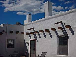 Casa del Gavilan |
January 30, 1978 (#100001882) |
570 State Road 21, S., 5.7 miles (9.2 km) south of Cimarron 36°26′19″N 104°57′25″W |
Cimarron | |
| 2 | Catskill Charcoal Ovens | January 30, 1978 (#78001813) |
35 miles (56 km) west of Raton 36°56′07″N 104°46′36″W |
Raton | ||
| 3 | Cimarron Historic District | 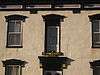 Cimarron Historic District |
April 3, 1973 (#73001140) |
Southern edge of city along State Road 21 36°30′16″N 104°55′17″W |
Cimarron | |
| 4 | Cimarron Mercantile | June 13, 2019 (#100003458) |
709 S. Collison St. 36°30′15″N 104°55′16″W |
Cimarron | ||
| 5 | Clifton House Site | 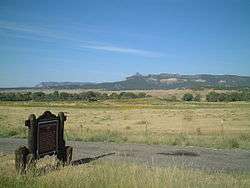 Clifton House Site |
April 7, 1995 (#94000325) |
Address Restricted |
Raton | |
| 6 | Colfax County Courthouse | 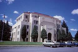 Colfax County Courthouse |
June 18, 1987 (#87000882) |
3rd and Savage 36°54′15″N 104°26′26″W |
Raton | |
| 7 | Colfax County Courthouse in Springer | 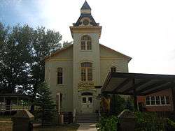 Colfax County Courthouse in Springer |
December 7, 1987 (#87000883) |
614 Maxwell Ave. 36°29′53″N 104°35′27″W |
Springer | |
| 8 | Columbian School | Columbian School |
March 15, 1996 (#96000261) |
700 N. 2nd St. 36°54′36″N 104°26′13″W |
Raton | |
| 9 | R.H. Cowan Livery Stable | 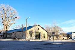 R.H. Cowan Livery Stable |
August 3, 1979 (#79001538) |
220 Maxwell Ave. 36°21′34″N 104°35′41″W |
Springer | |
| 10 | Dawson Cemetery | 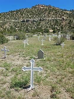 Dawson Cemetery |
April 9, 1992 (#92000249) |
Approximately 4 miles northwest of the junction of U.S. Route 64 and the Dawson Rd. 36°39′19″N 104°46′02″W |
Dawson | |
| 11 | Dorsey Mansion | September 4, 1970 (#70000399) |
About 12 miles northeast of Abbott off U.S. Route 56 36°29′12″N 104°11′28″W |
Abbott | ||
| 12 | Eagle Nest Dam | _Picture_1987.jpg) Eagle Nest Dam |
April 18, 1979 (#79001537) |
3 miles southeast of Eagle Nest off U.S. Route 64 36°31′54″N 105°13′44″W |
Eagle Nest | |
| 13 | El Raton Theater | 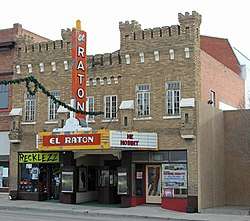 El Raton Theater |
January 17, 2007 (#06001250) |
115 N. 2nd St. 36°54′15″N 104°26′21″W |
Raton | |
| 14 | El Vado de las Piedras and the Santa Fe Trail-Colfax County Trail Segments | April 21, 1994 (#94000327) |
1.5 miles south of U.S. Route 56 at the Canadian River 36°18′10″N 104°29′21″W |
Springer | ||
| 15 | Folsom Site | 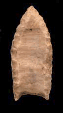 Folsom Site |
October 15, 1966 (#66000473) |
Address Restricted |
Folsom | |
| 16 | Immanuel Lutheran Church | 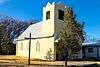 Immanuel Lutheran Church |
February 23, 2015 (#15000026) |
307 Summit Ave. 36°21′36″N 104°35′31″W |
Springer | |
| 17 | Kearny School | Kearny School |
March 15, 1996 (#96000259) |
800 S. 3rd St. 36°53′42″N 104°26′32″W |
Raton | |
| 18 | Longfellow School | .JPG) Longfellow School |
March 15, 1996 (#96000262) |
700 E. 4th St. 36°53′53″N 104°26′04″W |
Raton | |
| 19 | Maxwell-Abreu and North (Martinez) Houses | 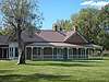 Maxwell-Abreu and North (Martinez) Houses |
June 23, 1993 (#93000253) |
Northwestern corner of the junction of State Road 121 and Rayado Creek 36°22′04″N 104°55′49″W |
Cimarron | |
| 20 | Mills House | 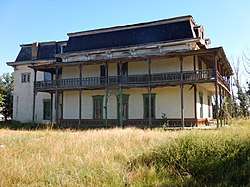 Mills House |
October 6, 1970 (#70000400) |
509 1st St. 36°21′26″N 104°35′30″W |
Springer | |
| 21 | Original Townsite Historic District | 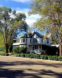 Original Townsite Historic District |
March 27, 2008 (#08000230) |
Roughly bounded by Clark and Cimmaron Aves. and S. 2nd and S. 7th Sts. 36°53′58″N 104°26′37″W |
Raton | |
| 22 | Point of Rocks Historic District | April 21, 1994 (#94000328) |
Jones Well Rd., 1.5 miles east of Point of Rocks Rd. 36°25′19″N 104°09′32″W |
Springer | ||
| 23 | Raton Armory | _-_Raton_Convention_Center(present).JPG) Raton Armory |
March 15, 1996 (#96000260) |
901 S. 3rd St. 36°53′33″N 104°26′33″W |
Raton | |
| 24 | Raton Downtown Historic District | 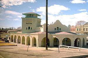 Raton Downtown Historic District |
October 21, 1977 (#77000923) |
Roughly bounded by Rio Grande, Clark, 1st and 3rd Sts.; also roughly bounded by 3rd St., Apache & Parsons Aves. 36°53′58″N 104°26′21″W |
Raton | Second set of addresses represents a boundary increase April 30, 2015. |
| 25 | Raton Junior-Senior High School | Raton Junior-Senior High School |
March 15, 1996 (#96000263) |
500 S. 3rd St. 36°53′51″N 104°26′31″W |
Raton | |
| 26 | Raton Pass |  Raton Pass |
October 15, 1966 (#66000474) |
U.S. Routes 85/87 on the Colorado/New Mexico border 36°59′19″N 104°29′11″W |
Raton | |
| 27 | Raton Pass Scenic Highway | 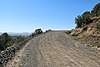 Raton Pass Scenic Highway |
September 17, 2015 (#15000605) |
Roughly from .1 mi. from jct. of Hill St. & Moulton Ave. continuing approx. 1.5 mi. on Scenic Hwy. 36°54′12″N 104°26′56″W |
Raton | |
| 28 | The Ring Place | July 19, 1988 (#88001054) |
Questa Ranger District in the Carson National Forest, Forest Rds. 1950 and 1918A 36°46′21″N 105°07′16″W |
Cimarron | ||
| 29 | St. John's Methodist Episcopal Church | 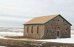 St. John's Methodist Episcopal Church |
January 18, 1978 (#78001814) |
17 miles (27 km) east of Raton on State Road 72 and Johnson Mesa 36°54′52″N 104°12′18″W |
Raton | |
| 30 | Villa Philmonte Historic District | 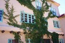 Villa Philmonte Historic District |
August 18, 1995 (#95001018) |
Philmont Scout Ranch 36°27′33″N 104°56′56″W |
Cimarron |
See also
| Wikimedia Commons has media related to National Register of Historic Places in Colfax County, New Mexico. |
References
- The latitude and longitude information provided in this table was derived originally from the National Register Information System, which has been found to be fairly accurate for about 99% of listings. Some locations in this table may have been corrected to current GPS standards.
- "National Register of Historic Places: Weekly List Actions". National Park Service, United States Department of the Interior. Retrieved on June 19, 2020.
- Numbers represent an ordering by significant words. Various colorings, defined here, differentiate National Historic Landmarks and historic districts from other NRHP buildings, structures, sites or objects.
- "National Register Information System". National Register of Historic Places. National Park Service. July 9, 2010.
- The eight-digit number below each date is the number assigned to each location in the National Register Information System database, which can be viewed by clicking the number.
| Topics | |
|---|---|
| Lists by state |
|
| Lists by insular areas | |
| Lists by associated state | |
| Other areas | |
| Related | |
| |
Municipalities and communities of Colfax County, New Mexico, United States | ||
|---|---|---|
| City | Map of New Mexico highlighting Colfax County | |
| Town | ||
| Villages | ||
| CDP | ||
| Other unincorporated communities | ||
| Ghost towns | ||
This article is issued from Wikipedia. The text is licensed under Creative Commons - Attribution - Sharealike. Additional terms may apply for the media files.