Mueang Kalasin District
Mueang Kalasin (Thai: เมืองกาฬสินธุ์, pronounced [mɯ̄a̯ŋ kāː.lā.sǐn]) is the capital district (amphoe mueang) of Kalasin Province, northeastern Thailand.
Mueang Kalasin เมืองกาฬสินธุ์ | |
|---|---|
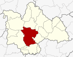 District location in Kalasin Province | |
| Coordinates: 16°25′57″N 103°30′22″E | |
| Country | Thailand |
| Province | Kalasin |
| Area | |
| • Total | 649.9 km2 (250.9 sq mi) |
| Population (2005) | |
| • Total | 145,579 |
| • Density | 224.0/km2 (580/sq mi) |
| Time zone | UTC+7 (ICT) |
| Postal code | 46000 |
| Geocode | 4601 |
Geography
Neighboring districts are (from the north clockwise) Sahatsakhan, Somdet, Na Mon, Don Chan, Kamalasai, Khong Chai, Yang Talat, and Nong Kung Si of Kalasin Province.
History
In 1913 the district was renamed from Uthai Kalasin to Mueang Kalasin.[1]
Administration
The district is divided into 17 sub-districts (tambons), which are further subdivided into 180 villages (mubans). The town (thesaban mueang) covers the whole tambon Kalasin. There are three townships (thesaban tambons): Nong So covers tambon Lam Pao and parts of Lamkhlong; Na Chan covers tambon Na Chan and parts of Phai and Phu Po; and Huai Pho covers tambon Huai Pho. There are a further 16 tambon administrative organizations (TAO).
| No. | Name | Thai name | Villages | Pop. | |
|---|---|---|---|---|---|
| 1. | Kalasin | กาฬสินธุ์ | - | 37,929 | |
| 2. | Nuea | เหนือ | 12 | 7,584 | |
| 3. | Lup | หลุบ | 15 | 10,831 | |
| 4. | Phai | ไผ่ | 9 | 5,122 | |
| 5. | Lam Pao | ลำปาว | 11 | 5,797 | |
| 6. | Lam Phan | ลำพาน | 16 | 8,973 | |
| 7. | Chiang Khruea | เชียงเครือ | 10 | 7,123 | |
| 8. | Bueng Wichai | บึงวิชัย | 9 | 6,052 | |
| 9. | Huai Pho | ห้วยโพธิ์ | 17 | 11,222 | |
| 11. | Phu Po | ภูปอ | 9 | 6,457 | |
| 13. | Phu Din | ภูดิน | 14 | 5,554 | |
| 15. | Nong Kung | หนองกุง | 8 | 4,827 | |
| 16. | Klang Muen | กลางหมื่น | 12 | 4,697 | |
| 17. | Khamin | ขมิ้น | 11 | 6,405 | |
| 19. | Phon Thong | โพนทอง | 8 | 5,658 | |
| 20. | Na Chan | นาจารย์ | 9 | 6,010 | |
| 21. | Lam Khlong | ลำคลอง | 10 | 5,338 |
Missing numbers are tambons which now form Don Chan District.
References
- แจ้งความกระทรวงมหาดไทย เรื่อง เปลี่ยนนามอำเภอ (PDF). Royal Gazette (in Thai). 30 (ง): 1619–1620. 19 Oct 1913.