Mount Kimball (Alaska)
Mount Kimball is the highest mountain in the section of the eastern Alaska Range between Isabel Pass (traversed by the Richardson Highway) and Mentasta Pass (traversed by the Glenn Highway), about 30 miles from Paxson.[4] It is one of the twenty most topographically prominent peaks in Alaska.
| Mount Kimball | |
|---|---|
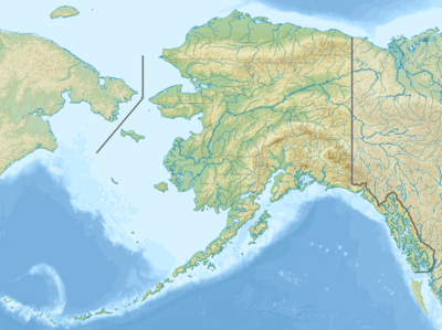 Mount Kimball Location in Alaska | |
| Highest point | |
| Elevation | 10,300+ ft (3,139+ m) |
| Prominence | 7,424 ft (2,263 m) [1] |
| Listing |
|
| Coordinates | 63°14′19″N 144°38′38″W [2] |
| Geography | |
| Location | Southeast Fairbanks Census Area, Alaska, U.S. |
| Parent range | Delta Mountains, Alaska Range |
| Topo map | USGS Mount Hayes A-2 |
| Climbing | |
| First ascent | June 13, 1969 by Tom Kensler, Mike Sallee, Dan Osborne, Grace Hoeman[3] |
| Easiest route | Southwest Ridge: glacier/snow/ice/rock climb (Alaska Grade 2+)[3] |
Mount Kimball is a relatively difficult climb for a peak with low absolute elevation, due to difficult ridge terrain, and it rebuffed eight climbing attempts by experienced Alaskan mountaineers before its first ascent in 1969.[3] Due to its remoteness, difficulty, and low stature compared to other major Alaskan summits, the peak is not often climbed.
See also
References
- This is an approximate figure, good to within 100 feet. See Alaska Ultra-prominent peaks at peaklist.org
- Mount Kimball on Topozone
- Michael Wood and Colby Coombs, Alaska: A Climbing Guide, The Mountaineers, 2001, ISBN 0-89886-724-X.
- U.S. Geological Survey Geographic Names Information System: Mount Kimball (Alaska)
External links
Juneau (capital) | ||
| Topics |  | |
| Society |
| |
| Regions | ||
| Largest cities pop. over 25,000 | ||
| Smaller cities pop. over 2,000 | ||
| Boroughs | ||
| Census Areas | ||
This article is issued from Wikipedia. The text is licensed under Creative Commons - Attribution - Sharealike. Additional terms may apply for the media files.